Central PA Hiking Guide: Mount Nittany, Rothrock & State College Trails
Penn State's backyard wilderness offers rocky ridges, old growth forests, and the iconic Mount Nittany overlook. All are within 20 minutes of State College.
Key Takeaways
- Raystown Overlook Hack: Most tourists stop at Ridenour Overlook. For a better view and total solitude, hike the short Hawn’s Overlook trail nearby; it offers a parallel perspective of the lake that remains largely undiscovered.
- The “Thousand Steps” Reality: Located on the Standing Stone Trail, this is a literal staircase up a mountain. Bring double the water you expect to need; once you leave the shade of the valley floor, the exposure to heat is intense.
- Mt. Nittany Trail Choice: Take the Blue Trail up for the iconic “Beaver Stadium” photo op, but switch to the White Trail for the descent. It’s slightly longer but significantly less punishing on your knees and ankles.
- Alan Seeger Old Growth: To see the 300-year-old hemlocks at their best, visit on an overcast morning. The deep creek valley creates a primordial, misty atmosphere that is lost in the harsh midday sun.
- Purple Lizard over GPS: Phone GPS is notorious for failing in the deep gaps of Rothrock State Forest. Pick up a Purple Lizard Rothrock Map in State College; it’s the only resource that accurately tracks the complex webbing of forest roads and singletrack.
If you went to Penn State, you know Mount Nittany. But for many people, Central PA is just a blur of farmland on the drive to the stadium. They are missing out.
Just minutes from downtown State College lies Rothrock State Forest. It is a landscape of rugged ridges and deep valleys. It offers some of the best hiking in the state.
This region is the perfect blend of accessibility and wilderness. You can grab a craft coffee in State College and hike a legendary overlook. Then you can disappear into the backcountry. You can do all this before lunch.
Why Hike Central PA?
If you grew up around State College, you know about Rocksylvania. And the stories aren’t exaggerated. Central PA hiking demands real boots and map skills. You will need a tolerance for scrambling over ancient shale ridges.
But here is the payoff. You get something rare: dramatic wilderness that is genuinely accessible. Most trailheads are 20 minutes from campus. You can knock out a serious ridge walk on a Tuesday evening.
The defining feature is the Ridge and Valley landscape. Parallel ridges run north-south, and each has its own character. Mount Nittany gives you the iconic valley views. Rothrock delivers raw wilderness and the infamous rock fields.
Black Moshannon offers high-elevation bog ecosystems you won’t find anywhere else in the state. Bald Eagle has old-growth hemlocks that feel genuinely remote.
Central PA hiking isn’t polished. The trails in Rothrock State Forest and along the Mid State Trail are notoriously rocky. Expect exposed shale, loose footing, and technical scrambles. Bring stiff boots and a map.
In return, you get sweeping vistas and genuine solitude. You’ll rarely see another hiker even on nice weekends.
The Trails: Choose Your Central PA Adventure
If You Want the Iconic View: Mount Nittany
Mount Nittany Loop:
- Distance: 4.6 miles (blue-blazed) or 3.5 miles (white-blazed)
- Elevation: 1,050 ft gain
- Time: 2.5-3.5 hours
- Difficulty: Moderate to strenuous (rocky, steep initial climb)
- Trailhead: Mount Nittany Conservancy parking area (off Route 45)
- Best Time: Fall for foliage (September 25-October 15), spring for wildflowers (April-May)
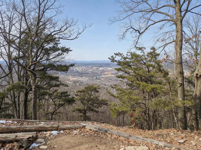
- The Draw: Mike Lynch Overlook with views of Beaver Stadium, Penn State campus, and Happy Valley
This is the must-do hike of Central PA. The trail climbs steep, rocky switchbacks to the flat summit.
From the Mike Lynch Overlook, you get the classic view of the valley. It is the one on every postcard. Beaver Stadium is visible in the foreground. The whole Happy Valley is laid out before you.
What to Expect: The first mile is the killer. It is constant switchbacks and loose rock underfoot. There are no views yet. You’re gaining elevation fast.
The second mile levels out onto the ridge proper. Suddenly you are walking through mixed forest with occasional vistas. The final push to the overlook is 0.3 miles from the summit.
The overlook gets crowded on nice weekends. If you want solitude, arrive before 9 AM.
The Conservancy lot has about 40 spaces. It often fills by 11 AM on weekends. The white-blazed shortcut cuts the distance to 3.5 miles.
But it skips some of the best ridge walking. It is worth it only if you are limited on time.
Pro Tip: Avoid football weekends (fall Saturdays). If you hike on a game day despite the crowds, start before 9 AM and plan to be off the mountain by noon. The parking situation becomes a nightmare by 1 PM when tailgaters show up.
Safety Note: The summit rocks are a popular party spot. If you’re hiking on a Saturday night in warm months, expect groups with coolers near the overlook.
If You Want Wilderness: Rothrock State Forest
Mid State Trail:
- Distance: 327 miles total (45+ miles through Rothrock)
- Elevation: Varies (constant ups and downs on ridges)
- Time: Multi-day backpacking trip
- Difficulty: Strenuous (rocky, remote, rugged)
- Access: Multiple trailheads (Shingletown Gap, Alan Seeger, Bear Meadows)
- Best Time: Fall (September-October) for foliage, spring (April-May) for cooler temps
- The Draw: The “wildest” trail in PA. Remote ridges, minimal crowds
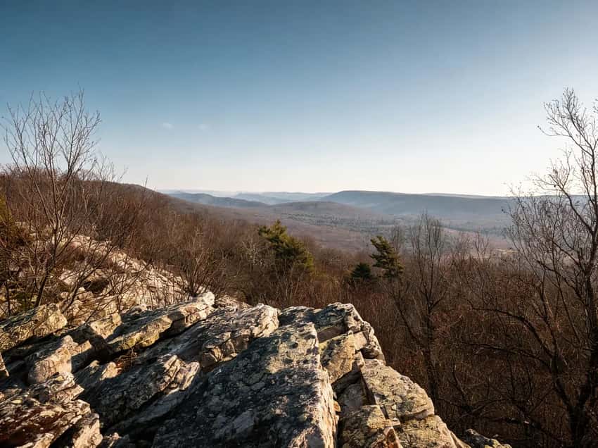
The MST is the wilder, rockier cousin of the Appalachian Trail. The section through Rothrock follows the ridge tops. It offers endless views and ankle-twisting terrain.
This is Rocksylvania at its finest. Expect loose shale and exposed rock. You will encounter trail markers you’ll miss if you’re not paying attention. It is for serious hikers who want genuine solitude.
What to Expect: Mile one is a brutal climb. The rock field opens up around mile two. The trail becomes a ridge walk with occasional descents into boulder fields.
You’ll gain and lose elevation constantly. Cell service is spotty at best. Expect to see maybe one or two other hikers all day.
Parking & Water: Shingletown Gap is the most accessible trailhead. The lot holds about 20 cars. Bear Meadows requires a permit. Alan Seeger has limited parking.
Bring all the water you need. Creeks are unreliable in dry months. The Mid State Trail has shelters at regular intervals if you’re backpacking.
Shingletown Gap:
- Distance: 2-6 miles (multiple loop options)
- Elevation: 400-800 ft gain (varies by route)
- Time: 1.5-3 hours
- Difficulty: Moderate
- Trailhead: Shingletown Gap parking area (off Shingletown Road)
- Best Time: Year-round (12 minutes from downtown State College)
- The Draw: Popular local hike with stream-side trails and ridge climbs
Just 12 minutes from downtown State College, this is a local favorite. It is where people go for a quick trail fix before a full Rothrock adventure.
The lower trails follow Roaring Run through old hemlock forests. The upper trails climb the ridge for a serious elevation gain.
What to Expect: The lower trail is easy and muddy. Expect water crossings. The upper loop gets steep fast. You’ll gain 400 plus feet in less than a mile.
The hemlock section feels genuinely remote despite being so close to campus. Fall colors are excellent here because of the hemlock and deciduous mix.
Parking & Water: The lot fills quickly on weekends (about 15 spaces). Arrive before 9 AM on nice days. Roaring Run provides water but should be filtered. The trail crosses the run multiple times, so you’re never far from a water source.
If You Want Unique Ecology: Black Moshannon State Park
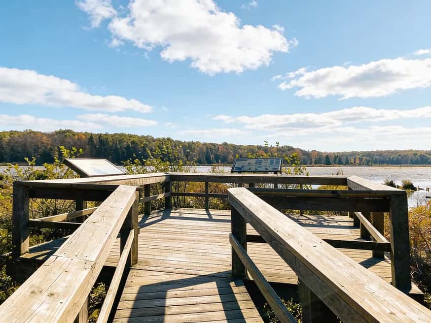
Bog Trail:
- Distance: 1 mile boardwalk loop
- Elevation: Flat (0 ft gain)
- Time: 30-45 minutes
- Difficulty: Easy (accessible, wheelchair-friendly)
- Trailhead: Black Moshannon State Park main parking area
- Best Time: Spring for wildflowers (May-June), summer for dragonflies (July-August)
- The Draw: Unique bog environment with carnivorous plants and tea-colored water
Perched atop the Allegheny Plateau, this park protects a rare mountain bog. It is one of only a handful in Pennsylvania.
The boardwalk trail takes you right over the water. You can see carnivorous pitcher plants, sundews, and sphagnum moss. The water is tea-colored from tannins. It stays cold even in the peak of summer.
What to Expect: The boardwalk is elevated above the water to keep you dry. The trail is genuinely easy and family-friendly.
Early morning between 7 and 9 AM is best for wildlife sightings. Look for dragonflies, frogs, and the occasional mink. The smell is peaty and distinctive. On misty mornings, it feels primordial.
Parking & Seasons: The main lot holds about 40 cars. Summer weekends can fill by 11 AM. June wildflower blooms are spectacular but brief.
July and August are peak for dragonfly season. Bring a camera and some patience. Winter is quiet and beautifully eerie.
Allegheny Front Trail:
- Distance: 42-mile loop
- Elevation: 1,200 ft cumulative gain
- Time: 3-4 days (backpacking)
- Difficulty: Moderate to strenuous
- Best Time: Fall (September-October) for foliage
- The Draw: Diverse terrain (bog, stream, vistas) around Black Moshannon
This is a serious multi-day backpacking loop that circles the park and surrounding ridges. Terrain varies from bog boardwalks to stream crossings to ridge climbs. Cell service is non-existent.
If You Want Old Growth: Bald Eagle State Forest
Snyder-Middleswarth Natural Area:
- Distance: 2-5 miles (multiple trails)
- Elevation: 400-600 ft gain
- Time: 1.5-3 hours
- Difficulty: Moderate
- Trailhead: Snyder-Middleswarth parking area (off Route 45)
- Best Time: Summer for cool shade (June-August), fall for foliage (September-October)
- The Draw: One of the few old growth hemlock forests in PA
This is one of the most excellent hikes in Central PA. The Tall Timbers section features hemlocks over 300 years old. Some tower 100 feet or more.
Walking through this forest feels genuinely remote. It is only 10 minutes from Route 45 but a world away.
What to Expect: The trail climbs gradually through the old growth. The forest floor is soft and the light is green and diffuse.
There is almost no undergrowth because the mature canopy blocks the sun. The air is cool and humid even on hot days. You’ll see massive downed trees slowly rotting after decades on the forest floor. The trail connects to larger loops if you want to extend your hike.
Parking & Access: The parking lot has about 25 spaces and rarely fills completely. Most tourists miss this trail but locals know it well.
Summer is the best time because the shade keeps it comfortable in the heat. Fall offers cooler temps and some color. The hemlocks stay dark green throughout the year. Winter is quiet and can be muddy.
Permit Note: Day use is free. No permit required for this area.
Mountain Laurel Season: June in Rothrock
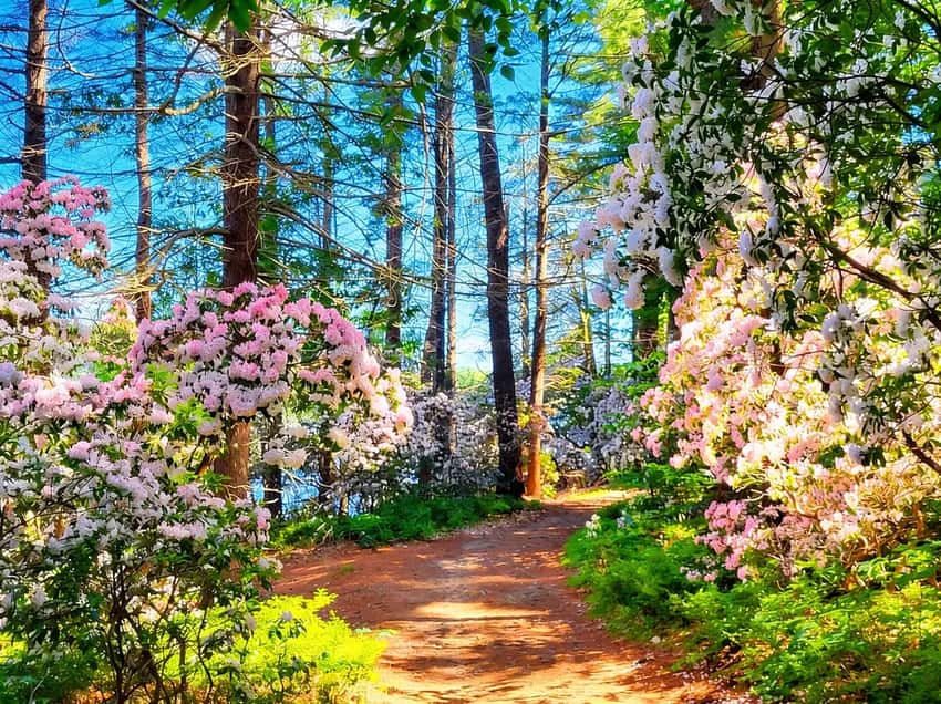
Pennsylvania’s state flower, the mountain laurel, puts on a spectacular show in this region. From early to mid-June, the ridges of Rothrock turn white and pink with blooms.
- Best Spot: The ridges around Shingletown Gap and Cooper’s Gap
- Peak Timing: June 5-20 (varies slightly by elevation and weather)
- Tip: The blooms are worth the drive. Plan a weekend trip just to see them
The Mid State Trail: Pennsylvania’s Wildest Hike
The Mid State Trail (MST) runs for 327 miles from the Maryland border to New York, passing right through the heart of Central PA. It is famously rocky and rugged.
- Why it’s wild: Unlike the AT, there are no shelters (except in a few spots) and fewer road crossings
- Difficulty: Expect slow miles. The rocks will slow you down
- Navigation: It’s blazed orange. You need a map
- Water: Limited sources. Plan carefully
Resource: The Purple Lizard Maps are the gold standard for this region. They are made by locals and show every trail, road, and water source.
Photography Tips for Central PA Hiking
The dramatic landscapes of Central PA offer excellent photography opportunities. You just need to time it right.
Best Overlook Photography: Mount Nittany Mike Lynch Overlook is the classic. Arrive at sunrise between 6:30 and 7:00 AM in the summer. You’ll get golden hour light across Happy Valley with Beaver Stadium in the foreground.
A wide-angle lens (16-35mm) captures the full panorama. The same light works in the fall when the valley shows its colors. October mornings are spectacular for this region.
Best Forest Photography: The old growth hemlocks in Bald Eagle State Forest deliver moody, intimate shots. Shoot on overcast days for even light. The massive trunks look better without harsh shadows.
A telephoto lens (70-200mm) isolates individual ancient trees. Bring a tripod and shoot at dusk for even moodier light. This is the place for serious landscape photography.
Best Seasonal Photography: Mountain laurel blooms in Rothrock are the signature moment. Peak is usually June 5 to 20. Shoot in the early morning between 6 and 8 AM. Late afternoon between 5 and 7 PM also offers soft light.
A macro lens captures the bloom details. If you are here in June, Rothrock is non-negotiable for photographers.
Best Bog Photography: Black Moshannon Bog Trail delivers ethereal, misty shots. Arrive at dawn when mist rises off the tea-colored water. Use a polarizing filter to cut glare and make the reflection more dramatic.
The carnivorous pitcher plants and sundews photograph well with macro settings. This is a unique opportunity you won’t find elsewhere.
Insider Tips: How to Hike Central PA Like a Local
Parking Hacks
Mount Nittany: The Conservancy lot is the official trailhead. Arrive before 9 AM on weekends. There is overflow parking on Route 45, but it is a longer walk. Avoid game days entirely.
Rothrock (Shingletown Gap): The main lot fills by mid-morning. Arrive before 8 AM or come on a weekday. If the lot is full, check the overflow parking just down Shingletown Road. It adds 10 minutes to the approach.
Black Moshannon: The main parking lot rarely fills. This is the least crowded trailhead of the four major areas in the region.
Bald Eagle (Snyder-Middleswarth): Parking is easy and the lot seldom fills. This is a well-kept secret that locals prefer.
Seasonal Reality for Central PA Hiking
Spring (March to May): Hiking is muddy through May. Stream crossings are aggressive during snowmelt (April). Wildflowers peak late April. Ticks emerge in April and reach dangerous levels by May.
Summer (June to August): Ridges like Mount Nittany and Rothrock get hot and exposed. Seek shade in old growth forests like Bald Eagle or take the bog trail at Black Moshannon.
Bugs are heavy. Bring DEET-based insect repellent. Water sources are generally reliable during this season.
Fall (September to October): Peak Central PA hiking season. Cool temps, crisp air, stunning foliage on ridges. Crowds are moderate but increasing.
Peak color lasts only 2 to 3 weeks. Weekend parking fills early.
Winter (November to March): Shale ridges become dangerous when icy. This is especially true after freeze-thaw cycles. Low-elevation forest trails like Bald Eagle or the Shingletown lower loop are safer.
Microspikes are essential after ice events. Bring hand warmers because the exposed ridges lose heat fast.
Safety Notes for Central PA Hiking
Ticks: All trails in the region have ticks from April through July. Use repellent. Do a full-body check after every hike including the groin and hairline. Watch for a bullseye rash after your trip.
Rattlesnakes: They are uncommon but present on rocky ridges. They aren’t aggressive and will avoid you if possible. Wear sturdy boots and watch for sheltered rocky areas. Make noise when you hike.
Exposed Rock: Rocksylvania is a real thing. Loose shale and exposed rock require your full attention. Stiff boots with ankle support are non-negotiable. Never hike these trails in worn shoes or thin trail runners.
Hunting Season: Blaze orange is mandatory in Pennsylvania from October 1 to November 15. Wear a bright orange vest on any trail. Nearby forests in Rothrock and Bald Eagle are popular with hunters. Stay visible.
Weather Changes: Mountain ridges experience rapid weather shifts. The temperature can drop 10 degrees in minutes. Bring a windproof jacket even if the sky is clear.
Camping in Central PA
Developed Campgrounds
Black Moshannon State Park:
- Sites: 80 tent/RV sites, 13 cabins
- Pricing: $19-$35/night (tent sites), $60-$90/night (cabins)
- Booking: Reserve 11 months in advance for summer weekends
- The Draw: Family-friendly, right on the lake
Poe Valley/Poe Paddy State Parks:
- Sites: 70+ rustic sites
- Pricing: $19-$25/night
- The Draw: Deep woods of Bald Eagle State Forest, famous for fishing
Dispersed Camping
You can camp for free in Rothrock and Bald Eagle State Forests, but you must get a free permit from the forest district office.
- Motorized Camping: There are designated sites you can drive to (reservation required)
- Backcountry: You can camp along the trails (like the MST) as long as you follow Leave No Trace principles
What You Need to Know Before You Go
Nearby Hubs
- State College: The hub. Hotels, breweries (Otto’s Pub, Elk Creek Cafe), gear shops (Appalachian Outdoors). Home to Penn State University.
- Bellefonte: Historic Victorian town, 15 minutes from State College. Fly fishing hub on Spring Creek.
- Boalsburg: Gateway to Rothrock, 10 minutes from State College. Pennsylvania Military Museum.
The Rocks
We can’t say it enough: Rothrock is ROCKY. Wear stiff hiking boots, not minimalist trail runners. Trekking poles are highly recommended to save your knees.
Footwear: Stiff-soled boots with ankle support
Poles: Essential for Mid State Trail sections
Pace: Expect 1-1.5 mph on rocky sections (vs. 2-3 mph on smooth trails)
Penn State Football Weekends
In the fall, the entire region transforms on home game weekends.
- Hotels: Book up to a year in advance and prices skyrocket ($200-$400/night)
- Traffic: Route 322 and Atherton Street become parking lots
- Trails: Mount Nittany will be packed. Go early (before 9 AM) or choose a different hike (like Black Moshannon)
- Football Schedule: Check Penn State Athletics for home game dates
Purple Lizard Maps
Don’t rely on Google Maps in the forest. Cell service is spotty at best. Pick up a Purple Lizard Map at Appalachian Outdoors in State College before you head out.
Why they’re essential: Official DCNR maps are outdated. Purple Lizard maps are maintained by local hikers and show every trail, water source, and camping spot.
Best Time to Visit
- Spring (April-May): Wildflowers and cool weather. Trails can be wet. Best dates: April 15-May 15 for wildflowers.
- Summer (June): Mountain Laurel season. It gets hot and humid, but the shaded valleys stay cool. Best dates: June 5-20 for peak blooms.
- Fall (September-October): Peak foliage and football energy. The woods are beautiful, but wear orange (hunting season). Best dates: September 25-October 15 for peak foliage.
- Winter (December-March): Solitude. The ridges get icy, and access roads may not be plowed.
FAQ
Is Mount Nittany hard? It is moderate to strenuous. The hike is short (under 5 miles) but the initial climb is steep and rocky. You’ll gain over 1,000 feet quickly.
Can I camp for free in Rothrock? Yes. You need a permit for dispersed camping. You can get one from the forest district office.
What is the best hike near State College? Mount Nittany offers the best views. For a quick forest walk, try Shingletown Gap. For unique ecology, go to the Bog Trail at Black Moshannon.
Is the Mid State Trail well-marked? It is blazed orange. But some sections can be overgrown. Always carry a physical map and a compass or GPS.
Explore More
Ready to explore Penn State’s backyard wilderness? Start with Mount Nittany for the iconic overlook, tackle the rocky ridges of Rothrock, and discover the unique bog ecology at Black Moshannon.
- Compare this to the Laurel Highlands for longer backpacking on the LHHT
- Check out the PA Grand Canyon for rim hiking and overlooks
- See the full PA State Parks list for more hiking ideas across the state