The 5 Buttermilk Falls of PA: Which One Do You Actually Want?
Google Maps will route you to five different counties if you search for Buttermilk Falls in Pennsylvania. Here is exactly how to tell them apart and which to visit.
Key Takeaways
- Navigation (Indiana County): For the “Mr. Rogers” falls and walk-behind ledge, use the Indiana County lot (Google Maps | Apple Maps).
- Navigation (Armstrong County): For the rail-trail and swimming hole, use the Johnson Avenue lot (Google Maps | Apple Maps).
- Location Ambiguity: There are five different Buttermilk Falls in PA. Double-check your GPS county (Indiana, Armstrong, Luzerne, Carbon, or Beaver).
- Tallest Drop: For scale, the 50-foot fall inside Lehigh Gorge State Park (Carbon County) is the most impressive and accessible via rail trail.
- History Highlight: The Indiana County location sits on the former estate of Fred Rogers’ (Mr. Rogers) grandfather and includes a well-marked historic trail.
If you type “Buttermilk Falls” into your GPS in Pennsylvania, you are rolling the dice. Depending on where you happen to be standing, the app might route you to a quiet creek near Kittanning, an intensive rail trail in the Poconos, or a roadside ditch outside Wilkes-Barre. All of them are waterfalls. None of them are connected.
No competing article actually explains this. This guide covers all five publicly accessible Buttermilk Falls in the state.
How Many Buttermilk Falls Are There in Pennsylvania?
There are at least five publicly accessible waterfalls called Buttermilk Falls in Pennsylvania. They span Indiana County (the Fred Rogers grandfather estate), Armstrong County (a rail-trail swimming hole), Luzerne County (a roadside waterfall), Carbon County inside Lehigh Gorge State Park, and Beaver County near Homewood. Each is a distinct location and entirely different experience.
Can You Swim at Buttermilk Falls PA?
It depends on which falls you visit. Swimming is strictly prohibited at the Indiana County location. However, the Buttermilk Falls in Armstrong County and Homewood Falls in Beaver County are popular, unregulated swimming holes. If you choose to wade or swim at either site, you do so entirely at your own risk.
The 5 Buttermilk Falls in Pennsylvania (An Honest Comparison)
To save you from driving two hours in the wrong direction, here is the breakdown of the five distinctly different waterfalls holding this name.
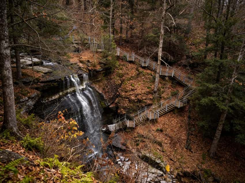
Buttermilk Falls: Indiana County (The Walk-Behind Falls)
This is the most famous location on the list. The 45-foot waterfall drops over a sandstone ledge that has severely undercut over time, allowing a steel-grate walkway to pass directly behind the curtain of water.
Buttermilk Falls Indiana County PA
Expert video guide showing the trail conditions and key viewpoints for this section.
The 48-acre property is managed by Indiana County Parks, but its real claim to fame is its history: the estate belonged to Fred McFeely, the beloved grandfather of Fred Rogers (Mister Rogers). The stone foundations of McFeely’s retreat are still visible along the short loop trail. Wading and swimming are not allowed here.
GPS: 40.7812, -79.2558 | Distance: 0.4 miles round-trip | Difficulty: Easy | Season: Year-round
Buttermilk Falls: Armstrong County (The Rail-Trail Swimming Hole)
This 46-foot cascade is completely different in vibe. Reached via the Cowanshannock Trail just north of Kittanning, you’ll walk about a mile on a crushed-stone rail trail built over an old Pennsylvania Railroad spur.
Buttermilk Falls Armstrong County PA
Expert video guide showing the trail conditions and key viewpoints for this section.
If you are using GPS, navigate to the parking area on Johnson Avenue (40.85082, -79.50725). This spot is a deeply popular, unofficial local swimming hole and fishing stretch. You will likely see rope swings strapped to the trees in the peak of July.
GPS: 40.8508, -79.5073 | Distance: 1.0-1.2 miles round-trip | Difficulty: Easy | Swimming: Permitted (unregulated)
Buttermilk Falls: Luzerne County (The Roadside Stop)
If you just want a quick hit of nature without leaving your car, this is your spot. Located on White Haven Road near Bear Creek Village, this 35-foot falls requires zero hiking. You just park in the dirt pull-off on the side of the road.
Buttermilk Falls Luzerne County PA
Expert video guide showing the trail conditions and key viewpoints for this section.
GPS: 41.0531, -75.7456 | Distance: 0 miles (roadside viewpoint) | Difficulty: Viewing only | Water Volume: Seasonal
⚠️ Warning: Spring thaw makes this waterfall roar, but by late August, it frequently shrinks to a miserable trickle. Do not make a dedicated drive for this one in the late summer.
Buttermilk Falls: Carbon County (Lehigh Gorge)
This 50-foot multi-tiered cascade is the most accessible waterfall on the list, and the most dramatic in terms of geography. It drops directly down the steep rock walls of the Lehigh Gorge into the river.
Buttermilk Falls Lehigh Gorge Carbon County
Expert video guide showing the trail conditions and key viewpoints for this section.
To reach it, park at the Rockport Access area in Weatherly, PA. From there, it is an easy 0.7-mile out-and-back walk on the D&L Trail within Lehigh Gorge State Park. Because the trail is paved and flat, it is universally accessible and highly trafficked by cyclists.
GPS: 40.8236, -75.6658 | Distance: 0.7 miles round-trip | Difficulty: Easy | Accessibility: Paved, fully accessible
Buttermilk Falls: Beaver County (Homewood Falls)
Often referred to locally as Homewood Falls, this 35-foot drop sits in a rocky, wooded pocket of Beaver County. Like the Armstrong County location, it functions as an informal, unregulated swimming spot for locals.
Buttermilk Falls Beaver County PA (Homewood Falls)
Expert video guide showing the trail conditions and key viewpoints for this section.
GPS: 40.3678, -80.5542 | Distance: 0.5-0.8 miles round-trip | Difficulty: Moderate | Swimming: Permitted (unregulated)
Pro Tip: If you plan to wade here, wear thick water shoes. The rocks are rough, and the unfortunate reality of unsupervised swimming holes is that broken glass is frequently buried in the splash pool.
Which Buttermilk Falls Should You Visit?
If you want to skip the reading, use this quick-decision matrix to pick your destination:
- Want to walk behind the waterfall + history? → Indiana County
- Want a rail trail hike + a swimming hole? → Armstrong County
- Want a quick family stop without hiking? → Luzerne County
- Want an easy, paved path + the biggest drop? → Carbon County (Lehigh Gorge)
- Want an unofficial swimming spot near Pittsburgh? → Beaver County
Planning Your Visit
All five of these waterfalls are free to access. If you are hitting the more remote, unregulated falls (like Armstrong or Luzerne counties), do not expect cell service to save you. Download your maps before leaving the nearest town.
If the Lehigh Gorge falls cracked your waterfall appetite, the Poconos region guide covers the rest of the eastern side of the state. If you lean westward, the Northwest PA region guide lists more western Pennsylvania cascades worth the drive.
Photography Tips: The Five Falls Compared
Indiana County (Walk-Behind): Shoot from beneath the undercut ledge where the walkway leads. Overcast light creates even exposure on the sandstone. The steel grate walkway is iconic:include it in your composition to show the unique access point.
Armstrong County (Rail Trail): Golden hour works well here since the falls is more open to directional light. The surrounding deciduous forest provides framing. Spring (peak water) and fall (colors) are optimal shooting seasons.
Luzerne County (Roadside): This location is challenging photographically because it’s a quick roadside stop. Use a polarizer to cut glare from wet rocks. Arrive during overcast conditions for best results.
Lehigh Gorge (D&L Trail): The paved trail context is important:include it in composition to show accessibility. The multi-tiered cascade plays well with wide-angle lenses capturing gorge walls. Cyclists are frequent, so arrive early for empty shots.
Beaver County (Homewood): Similar to Armstrong County, this unregulated site photographs best during golden hour or overcast conditions. The rocky pocket setting creates natural framing.
Last Updated: April 17, 2026