Visiting Centralia PA in 2026: What's Actually Left
Graffiti Highway is buried. Here is exactly what remains of the PA abandoned town today, how to park legally, and whether it's worth the drive.
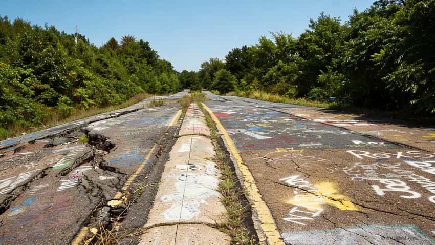
Graffiti Highway was permanently buried in 2020. Most of the abandoned houses in old videos have been demolished.
If you drive to Centralia today expecting a movie set, you will stand in a dirt field feeling confused. Here is exactly what is left of the Pennsylvania abandoned town in 2026. This guide helps you decide if it is worth the drive.
Key Takeaways
- Navigation: Use roadside shoulders on PA-61 or spaces within the public borough grid (Google Maps | Apple Maps). GPS: 40.8039, -76.3406. Avoid blocking residential driveways.
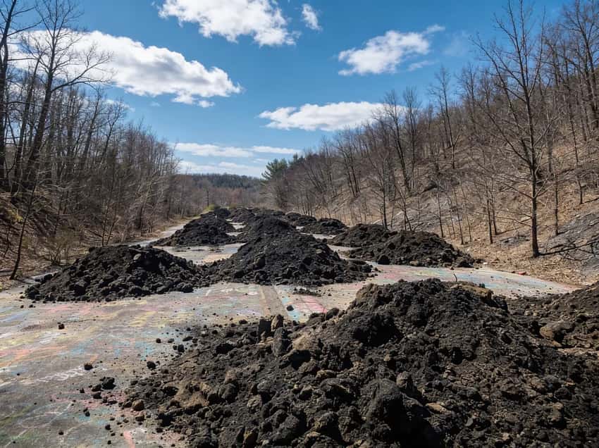
- Graffiti Highway Alert: The famous “Graffiti Highway” was permanently buried under a dirt berm in 2020. Do not visit expecting to find it.
- Terrain: Easy urban exploration on mostly paved street grids. There are approximately 1 to 3 miles of walking through the abandoned townsite.
- Safety Warning: Not recommended for dogs due to ground sinkhole risks and undetected carbon monoxide vents from the underground mine fire.
What Happened to Centralia
In 1962, a trash fire ignited an exposed coal vein beneath the Centralia borough dump. Exactly which fire caused it has been disputed for decades. The result was a fire that proved impossible to extinguish.
By the 1970s, carbon monoxide was venting into basements. In 1981, a 12-year-old boy nearly fell into a steaming sinkhole that opened beneath his feet in his grandmother’s backyard. The sinkhole was 150 feet deep.
Congress allocated $42 million for relocations. Residents left in waves through the 1980s.
The population plummeted from a peak of nearly 2,700 to five residents as of 2026. Those five remain under a lifetime agreement with the Commonwealth of Pennsylvania, they may live out their years in Centralia, but when they pass, their properties revert to the state. The borough’s ZIP code, 17927, was revoked in 2002.
Centralia is not a maintained tourist site. There are no visitor centers, no official trailheads, no rangers, and no infrastructure of any kind for visitors. Just empty streets going nowhere, maintained as public roads by the Commonwealth.
Graffiti Highway: Why It’s Gone and What You’ll Find There Now
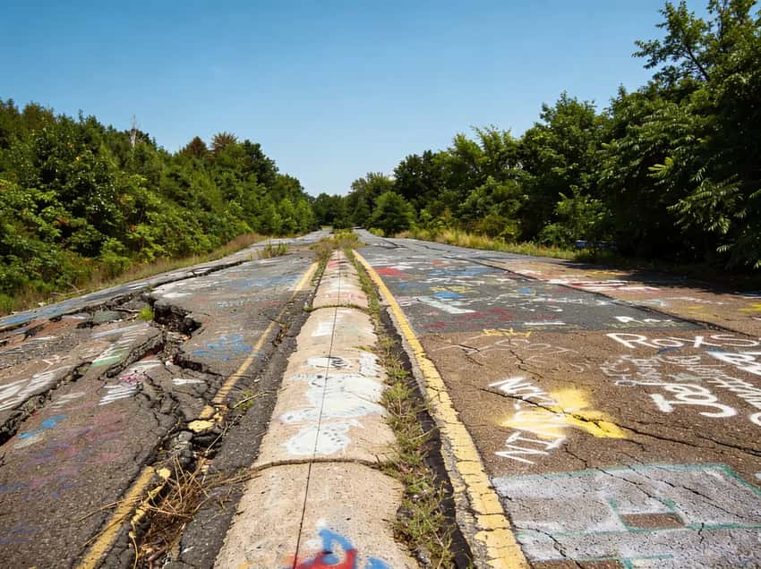
The abandoned stretch of old Route 61 was once covered edge-to-edge in spray paint. It was documented in thousands of photos. In April 2020, Pagnotti Enterprises buried it under thousands of tons of dirt.
They did this to stop visitors. The site was attracting too many people and the liability became untenable.
Today, that section of road is a flat, grass-covered berm. There is nothing to see. The photos that dominate Google search results are years old. If this is specifically what you are coming to see, save the drive.
What Is Actually Left to See
The Street Grid
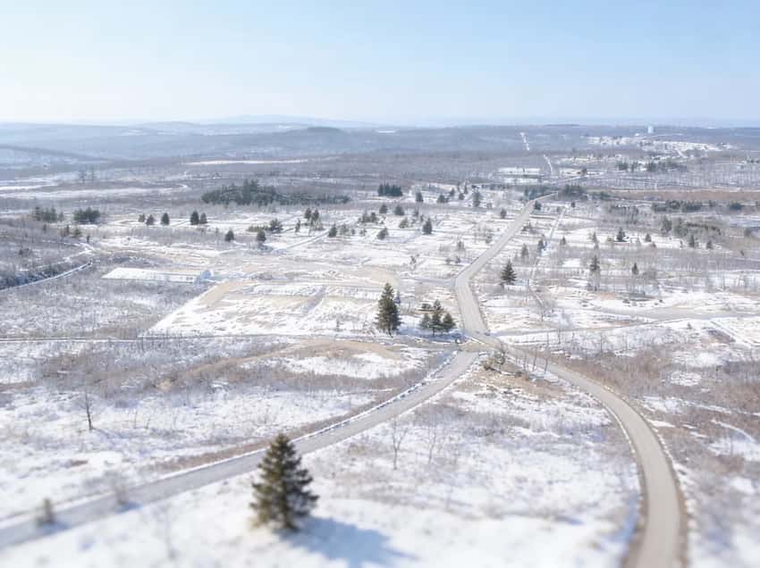
This is the main thing left. You can walk the abandoned residential blocks where entire neighborhood streets end at nothing. Sidewalks, curbs, fire hydrants, and brick steps lead to overgrown lots.
It is a strange and unsettling experience. You will find functioning civic infrastructure with no community left inside it. Streets are maintained as Commonwealth property and are open to the public.
Budget 60 to 90 minutes to cover the main grid properly. The blocks are compact but walking every remaining street adds up.
The Cemeteries
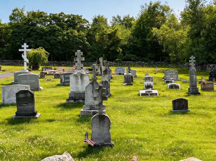
Several cemeteries remain in active use. The Odd Fellows Cemetery on the hill is the most visited. Its elevated position gives you a clear look at the scope of what is gone.
You can see the grid below and the empty ridgeline. On cold mornings, steam vents are often visible in the depression areas near the old mine workings.
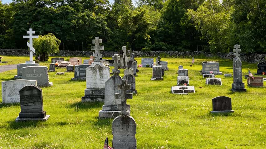
The Russian Orthodox and Lithuanian cemeteries on the southern edge of the grid are smaller but quieter. All three see regular maintenance by descendants of former residents.
The Church on the Hill
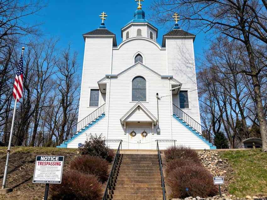
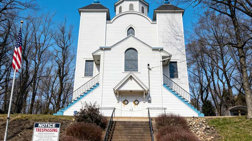
The Assumption of the Blessed Virgin Mary Ukrainian Greek-Catholic Church sits on a hilltop overlooking the former town. White exterior, blue and gold steeples, structurally intact.
It is the only survivor of the five churches that once existed in Centralia and still holds weekly services. The centraliapa.org community site has current service information. Do not visit on a Sunday morning expecting to photograph the exterior, services are active and residents deserve the same consideration any functioning congregation does.
Smoke and the Mine Fire
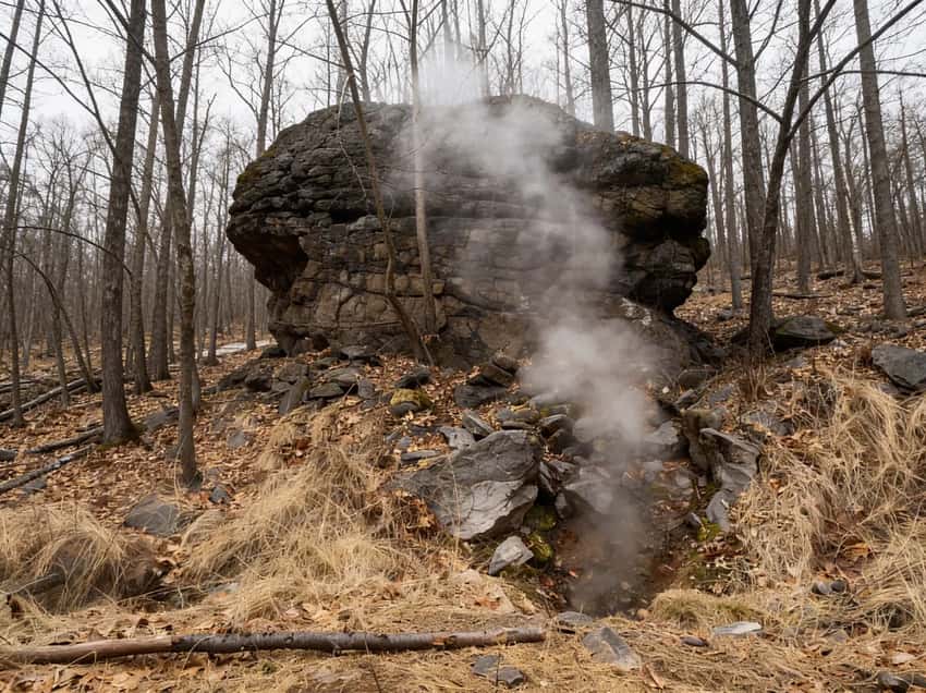
The fire burns roughly 100 feet underground across an estimated 400-acre area, according to Pennsylvania DEP monitoring reports. Geologists estimate it could continue for another 200 to 250 years depending on the remaining coal seam.
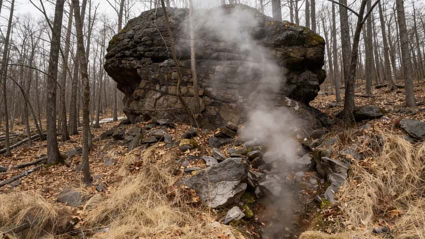
Visible steam or smoke is rare on dry and warm days. If you go on a sunny Saturday in July, you will see nothing. Your best conditions are a cold morning below 40 degrees with overcast skies.
The steam vents are most visible from the Odd Fellows Cemetery and the low sections along Locust Avenue. Do not go expecting dramatic plumes. Many visitors see nothing at all.
The Sensory Experience of Walking the Grid
Reading about Centralia and standing in it are very different things. The silence catches most people off guard first. There are no ambient sounds from a neighborhood: no lawnmowers, no kids, no music from open windows. Just wind and, occasionally, the faint hiss of a vent.
The smell is the second thing. When vents are active, you catch a faint sulfur note, not overwhelming, but unmistakable. It is the smell of something burning far below your feet, which is exactly what is happening.
The infrastructure is what makes it genuinely strange rather than just sad. You walk a curb-lined block where every detail says “neighborhood” except the houses. Fire hydrants still stand at proper intervals. Street signs still name intersections. Concrete steps climb four feet to nothing but weeds where a front door would have been.
Stand at one of those staircases and think about the math: a family once stood on that stoop, probably daily, for decades. Now you are the only person in view. That combination of intact detail and complete absence is what no photograph quite captures.
Photography Guide
Centralia rewards patience and punishes expectation. Here is how to actually get useful shots.
Best Light and Timing
Come early on a weekday in October or November. The light is low-angle by 7:30 AM and the weeds have started dying back, giving you clean sightlines down the empty blocks. Overcast skies are your friend here: harsh midday sun flattens the texture of the cracked asphalt and bleaches the cemetery headstones.
If you want any chance of capturing visible steam, you need temperatures below 40 degrees and calm air. The best window is roughly 7 to 10 AM before the ground warms. Bring a tripod if you shoot in low light.
Specific Shots Worth Planning
The Odd Fellows Cemetery gives you the clearest compositional payoff. Frame a row of headstones with the empty grid visible in the background and, on a cold morning, a wisp of steam in the low ground between. Shoot from the uphill side of the cemetery looking southwest.
The staircase shots require walking the blocks systematically. Look for concrete front steps that still have intact handrails. Some are partially buried in debris; others are perfectly preserved. These make strong foreground subjects against an empty lot background. You will find several along the intersections of the former residential blocks.
The church on the hill works best from below, looking up. Shoot from the east side in morning light to get the facade lit and the ridge behind it in shadow.
Gear Notes
A 24-70mm range covers almost everything here. A 70-200mm lets you compress the distance between a foreground detail (a fire hydrant, a street sign) and the visible ridgeline or cemetery behind it. Bring lens cloths: if vents are active, the mist can settle on glass faster than you expect. A wide-angle lens gets awkward fast in the tight grid; the blocks are too compact for dramatic wide shots to work unless you use them at ground level for the staircase angles.
How to Get There and Where to Park
Centralia is on PA-61 in Columbia County, approximately two hours from Philadelphia and two and a half from Pittsburgh. You can also approach via PA-54 from the east.
There is no designated parking lot. Park on the public shoulders of the streets within the grid, or in unpaved pull-offs along PA-61.
Pro Tip: Do not park in front of the remaining five houses or block any driveways. People still live here. Local law enforcement patrols the area regularly and responds to complaints from residents. Blocking access to active properties is the single fastest way to make Centralia less accessible for future visitors.
Hazards and Rules
Walking the public rights-of-way, roads and sidewalks on Commonwealth-owned land, is legal. Trespassing on the remaining five private properties or any posted restricted areas is not. Keep to the streets.
Ground subsidence is a real hazard. Stay on paved roads and maintained sidewalks. Do not walk on asphalt that is visibly cracked or heaving. Do not step on ground that looks sunken, especially in areas away from the street grid.
Carbon monoxide can accumulate in low depressions and near vents, especially in still air. Do not sit or lie down in sunken ground. If you smell sulfur or feel dizzy, leave the area immediately.
The danger areas are generally obvious, such as cracked and steam-venting ground. But the risk is real. This is why dogs are not recommended. A dog cannot assess the danger.
No facilities. No restrooms, no gas, no food anywhere in the borough. Closest facilities: Ashland, PA, about three miles south on Route 61.
Cell service. Generally fine on the main roads through the grid. Gets spotty on the western edge of town.
Best Time to Visit
October through April is the right window. Vegetation is low. The remaining structures and the street grid are fully visible.
Underground steam vents are more photogenic in cold air. Tourist traffic is lowest.
Late October is the single best combination: the remaining trees are in color, the weeds are dying back, the light is low-angle and warm, and you will likely walk the entire grid without seeing another visitor on a weekday.
Avoid summer. The grid is overgrown by June. Tick activity is high from May through September. The steam vents are effectively invisible in warm air.
Is It Worth the Drive?
Visiting Centralia is a quiet, slow experience. You walk streets laid out for a town that no longer exists, past steps that lead nowhere and fire hydrants protecting nothing. If industrial history or slow-burn American decline is something you find worth understanding in person, yes, it is worth the drive.
If you have watched the 2017 YouTube videos and expect the Graffiti Highway to be there, you will leave frustrated.
For the broader Central PA picture, visit the region guide. It covers the Susquehanna ridgelines, coal history, and the Appalachian Trail corridor.
What to Combine with Centralia
Centralia takes 90 minutes to two hours on the ground. If you are driving from Philadelphia or Pittsburgh, the round trip is most efficient as part of a longer day. Here are sites that pair well without heavy backtracking.
Ashland, PA - Pioneer Tunnel Coal Mine
Ashland is three miles south on Route 61. The Pioneer Tunnel Coal Mine offers underground tours of an actual anthracite mine, which provides a direct counterpoint to what you just saw above Centralia. Open seasonally from April through October (adult tickets approx. $18–$20), the open-car mine train travels 1,800 feet deep into Mahanoy Mountain under the guidance of retired miners. Check their official schedule at pioneertunnel.com before planning your day. The combination of seeing the mine tour first and Centralia second puts both in sharper context: you understand the scale of the seams underground, then walk the surface of what happens when those seams catch fire.
Concrete City, Nanticoke PA
Concrete City in Nanticoke is about 45 minutes northeast on Route 61 and then PA-11. It is an abandoned company housing complex from the early 1900s, concrete duplex blocks left standing in the woods. The appeal is different from Centralia: the structures are intact rather than absent, and the setting is forested rather than open. If you are making a day of Pennsylvania industrial ruins, these two pair cleanly as a morning-afternoon combination, both featured in our roundup of the best abandoned places in Pennsylvania.
Ricketts Glen State Park
About 40 minutes (35 miles) north of Centralia via PA-42 and PA-487 on the edge of the Poconos region, Ricketts Glen State Park is home to the premier waterfall hike in Pennsylvania. The Falls Trail loop features 21 named waterfalls over rugged stone steps (requiring sturdy hiking boots, never flip-flops), and the main PA-487 parking lot fills to capacity early on weekends (often by 9:30 AM). If you want to balance the flat, quiet weight of Centralia with something active and scenic, Ricketts Glen is the move. Do Centralia in the morning while the steam vents are active, then drive north for the falls in the afternoon.
The Abandoned Turnpike
The Pennsylvania Abandoned Turnpike tunnel sections are roughly two hours south of Centralia near Breezewood. This does not pair well as a same-day trip unless you are coming from the south, but it belongs on the same itinerary for anyone building a dedicated Pennsylvania ruins road trip.
FAQ
Is Centralia open to the public? Yes. The public road rights-of-way and Commonwealth-owned streets are open to visitors. You cannot trespass on the five remaining private properties or any posted restricted areas. Walking the street grid, visiting the cemeteries, and viewing the church exterior from public property are all legal.
Can I bring my dog? The official recommendation is no. Ground subsidence hazards and carbon monoxide vents are the two main concerns. A dog cannot recognize those risks or communicate distress clearly enough to give you advance warning. Leave them home for this one.
Where is Graffiti Highway now? Buried. In April 2020, Pagnotti Enterprises covered the former Route 61 stretch with thousands of tons of dirt. The location is a flat, grassy berm now. If you search Google Images for Centralia, the photos showing colorful spray-painted asphalt were taken before 2020 and no longer reflect current conditions.
How many people still live in Centralia? Five residents as of 2026, living under a lifetime agreement with the Commonwealth of Pennsylvania. When they pass, their properties revert to the state. They are actual residents, not caretakers, and deserve the same consideration you would give any neighbor. Do not approach, photograph, or enter private properties.
When is the mine fire likely to burn out? Geologists estimate another 200 to 250 years, depending on the remaining coal seam depth and extent. The fire has been burning since 1962. There is no active suppression effort; the cost and difficulty of extinguishing a fire at that depth made it unfeasible decades ago.
Is it safe? Walking the public streets is reasonably safe if you use common sense. Stay on paved roads and maintained sidewalks. Do not walk on visibly cracked or heaving asphalt. Do not step into depressions or sunken ground, especially away from the street grid. If you smell sulfur strongly or feel dizzy, leave the immediate area. Carbon monoxide has no smell, so the sulfur note is your only sensory warning. Groups with children should keep close supervision on the kids at all times.