Ferncliff Peninsula Trail: How to Find the Fossils in Ohiopyle
The sandstone ledges at the river's edge are covered in 300-million-year-old plant fossils. Here is exactly where to find them and how to hike the full loop.
Most people visiting Ohiopyle State Park spend their time at the main falls overlook. It is crowded, loud, and worth about five minutes.
Walk across the bridge to Ferncliff Peninsula and you are in a different world: a 2-mile loop through a National Natural Landmark where the sandstone bedrock at the river’s edge is covered in 300-million-year-old plant fossils. They are not behind glass. You can put your hand on them. This guide tells you exactly where they are and how to find them.
Key Takeaways
- Navigation: Use the dirt lot off PA-381 directly across from the main Ohiopyle Falls (Google Maps | Apple Maps). GPS: 39.8656, -79.4952.
- Primary Interest: Hunt for 300-million-year-old plant fossils (Lepidodendron, Calamites) imprinted on the sandstone ledges along the river’s edge.
- Difficulty: A very easy 1.9-mile loop, significantly flatter and quieter than the nearby Meadow Run or main falls area.
- Safety Caution: Strictly no swimming. The Youghiogheny River runs through dangerous Class III-IV rapids at the peninsula’s edge.
Why Ferncliff Is a National Natural Landmark
The peninsula was designated a National Natural Landmark in 1974 for two reasons. The fossils get most of the attention, but the botanical ecosystem that developed here is equally unusual and is actually what drove the NPS designation.
The Fossils
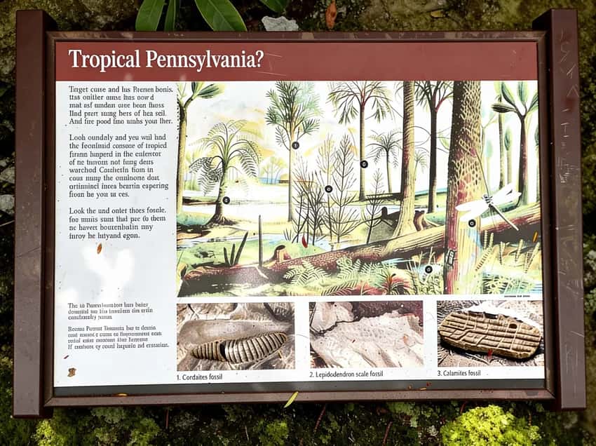
The sandstone bedrock along the river bank, particularly on the downstream eastern side of the loop, is imprinted with plant fossils from the Carboniferous period. Pennsylvania was a tropical swamp 300 million years ago, well before dinosaurs existed. The plants that lived in those swamps are pressed into the rock you walk on.
Three species appear most frequently on the exposed ledges:
- Lepidodendron: Scale trees that grew 100 feet tall. The bark pattern looks like overlapping scales or snake skin, you will recognize it immediately once you know what to look for.
- Cordaites: Early conifer ancestors with long, strap-like leaves. Less visually distinctive than Lepidodendron but present throughout the exposed ledges.
- Calamites: Giant horsetail plants that also reached 100 feet. The segmented stem impressions look like elongated bamboo sections in the rock.
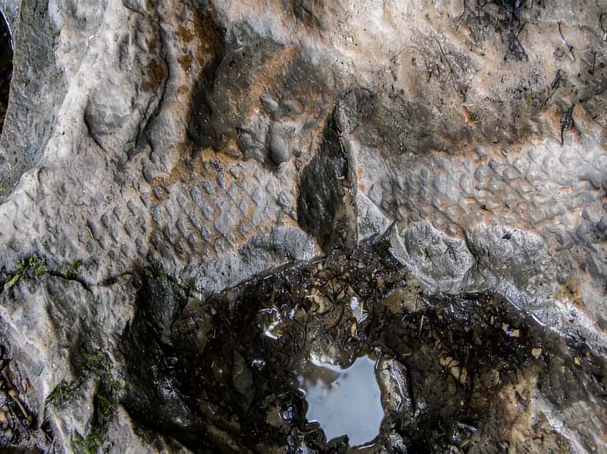
Lepidodendron impression on the Ferncliff sandstone. The scale-bark pattern is the easiest to identify.
How to find them: The best exposures are on the flat sandstone ledges closest to the water on the eastern (downstream) side of the loop, roughly halfway to two-thirds of the way around from the parking area. They are easiest to see when the rock is wet. Bring a water bottle and splash the surface, the fossil impressions darken and pop when wet.
Low-angle morning or late afternoon light also helps. Midday sun flattens the texture.
Important: This is a National Natural Landmark. Looking and photographing is encouraged. Removing fossils is a federal offense under the Archaeological Resources Protection Act and damages the site for every subsequent visitor. Leave them where they are.
The tropical swamp plants of Carboniferous Pennsylvania, preserved in river sandstone at Ohiopyle.
The Botanical Anomaly
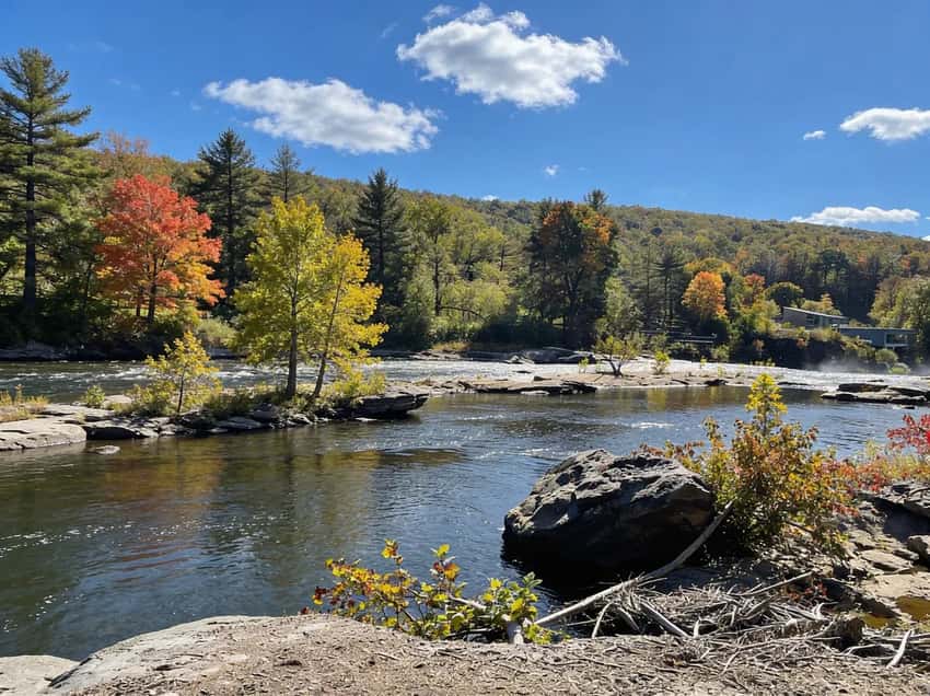
The Youghiogheny River flows north through Ohiopyle, which is unusual for a major Pennsylvania river.
The horseshoe bend around the peninsula acts as a seed trap: plant material washing downstream from the river’s headwaters in West Virginia and Maryland gets caught in the bend and deposited on the peninsula. Over centuries, that seed bank produced a botanical community that contains plant species rare or entirely absent elsewhere in Pennsylvania.
The forest on Ferncliff reflects this accumulation. Towering hemlocks, white pines, and giant oaks dominate the canopy. The understory carries species native to the mid-Appalachians that do not typically establish this far north in Pennsylvania.
DCNR botanists monitor the preserve specifically because of how unusual the plant community is.
For visitors, this translates into a forest that looks noticeably older and denser than the surrounding Laurel Highlands woodland, which is visible the moment you cross the bridge from town.
The Trail
The loop follows the perimeter of the peninsula. One continuous path, clear and well-maintained, no junctions to navigate.
Getting to the Trailhead
The Ferncliff Natural Area has a dedicated dirt parking lot off PA-381, located just across the river bridge from the main Ohiopyle falls area. It holds fewer cars than the main lot and tends to fill on summer weekends, but it is consistently less chaotic.
If the lot is full, park in Ohiopyle town and walk across the high bridge (the GAP trail bridge). That route adds roughly half a mile and gives you an aerial view of the full peninsula and the horseshoe bend before you drop down to the trail.
The trail entrance is at the far end of the Ferncliff lot. Follow the path away from the parking area along the river.
The Clockwise Route (2 Miles)
Most hikers go clockwise from the lot along the river’s edge, loop around to the inland side, and return.
First half (river side, ~1 mile): The trail follows the river bank closely on the downstream eastern side. This is the fossil section. Walk slowly here and look at the flat sandstone ledges below the trail at the water’s edge.
The fossils are on those exposed horizontal surfaces, not on vertical rock faces. Plan 30 to 45 minutes for this section if you want to properly look.
Two named viewpoints appear in this section: Washington’s Overlook and Lovers Leap. Both offer clear looks at the Yough and the surrounding gorge walls. Lovers Leap is the better of the two for photos.
Ferncliff side of Ohiopyle Falls: The trail approaches close to the lip of Ohiopyle Falls from the peninsula side before the main visitor area. This viewpoint is quieter and often gives you a better angle than the main overlook, which is standing-room-only on summer weekends. You can get within a few feet of the falls’ edge on this side.
Second half (inland side, ~1 mile): The return section runs through the interior of the peninsula on the higher wooded ground. Less dramatic than the river side, but the forest here is dense and the canopy is loud with birds in spring and early summer. Rhododendron and mountain laurel line portions of the trail. Mountain laurel blooms in late May to mid-June and covers this section in pale pink clusters.
The horseshoe bend of the Youghiogheny around Ferncliff, visible from the GAP bridge before you descend to the trail.
The trail is mostly flat with minor undulation. Rocky and rooty in spots, particularly on the river-side section near the fossil ledges, but nothing that requires scrambling or special footwear beyond basic trail shoes.
Safety
River Hazard
The Youghiogheny runs class III-IV rapids through the Loop section surrounding the peninsula. The current is powerful enough to hold a swimmer under. Do not enter the water.
Do not climb out onto the exposed midstream rocks regardless of how stable they look. The casualty record on the Yough in Ohiopyle is serious, this is a working whitewater run, not a swimming area.
Wet rocks near the bank are ice-slick even in summer. The river spray keeps the ledge surfaces permanently damp. If you are scrambling out onto the sandstone to look at fossils, use deliberate footing and stay aware of where the edge is. Keep children and dogs physically back from the bank while you examine the ledges.
Falls Lip
The section of trail closest to Ohiopyle Falls has no railing. The rock at the lip is wet from spray and angled slightly toward the water. Get your photos from a stable standing position and step back before moving.
Ticks
The peninsula’s dense understory and high wildlife activity make it tick habitat from April through October. Wear long sleeves into the interior section and run a full tick check on yourself, your kids, and your dogs when you return to the parking lot.
Poison Ivy
Present along the trail edges, particularly on the inland return section. If you step off the marked path to look at something, check before you crouch into the vegetation.
What to Bring
The trail is short and easy. The packing list is minimal.
- Water, one liter per person. No water source on trail.
- Comfortable trail shoes, waterproof if you are hiking in spring. The rocks near the river stay wet.
- A water bottle for the fossils, splash the sandstone ledges to make the impressions visible. This is worth doing.
- Tick kit, tweezers or tick hook. Check after the hike.
- Bug repellent, May through September. The dense understory holds mosquitoes.
- Camera, the fossil impressions photograph better in low-angle light. Morning or late afternoon visits produce the best shots.
No scrambling gear needed. Sandals are borderline on the rocky ledge sections, trail shoes with any grip are safer and more comfortable.
Best Times to Visit
Spring (April through May): Water is high, which makes the Yough and the falls dramatic. Wildflowers emerge on the inland section in April. Ticks become active in May. Mud possible on the inland trail after rain.
Early summer (June): Mountain laurel and rhododendron bloom in June, covering the inland return section in color. This is the best single month for an all-around visit. The falls are still running well from snowmelt.
Summer (July through August): Hot and more crowded than shoulder season. The foster ledges are dry, which actually makes the fossils harder to see without wetting the surface yourself. Go early or late to avoid the Ohiopyle midday crowd spilling across to the peninsula.
Fall (October): The foliage over the river from the Lovers Leap viewpoint is worth a separate trip. The Yough’s dark water against the orange and red canopy on the gorge walls is a strong combination. Crowds drop noticeably after Columbus Day.
Winter: The trail stays open but the river-side ledge section ices in hard freezes. The inland section stays passable. Check Ohiopyle State Park alerts before going in December or January.
FAQ
Where exactly are the fossils? On the flat, horizontal sandstone ledges along the river bank on the downstream eastern side of the loop, roughly the first mile if you go clockwise from the parking lot. Look at ledge surfaces closest to the water, not vertical rock faces. Wet the surface with water to make impressions pop.
Can I swim at Ferncliff Peninsula? No. The Youghiogheny runs class III-IV whitewater rapids around the peninsula. There is no calm access point. Swimming is prohibited and genuinely dangerous here.
Is this a good trail for young kids? Yes, with supervision. The trail is short, flat, and has a clear destination (the fossils). Keep children physically back from the river bank while looking at the ledges, the rocks are wet and the current is powerful. The inland return section is completely safe.
Is the trail paved? No. Dirt singletrack with roots and rocks, particularly on the river-side section.
Is it dog-friendly? Yes, on a leash. The rocky, wet ledge sections are harder on dogs than on humans, keep dogs on a short leash near the river bank, and check for ticks on the inland section.
How does this compare to Cucumber Falls nearby? Different in character. Cucumber Falls is a short walk to a single dramatic waterfall. Ferncliff is a full loop with geology, botany, river views, and no single dramatic moment, it rewards attention more than impact. Both are in Ohiopyle State Park and pair well on the same day.
Ferncliff is the part of Ohiopyle State Park that visitors tend to either skip entirely or remember as the highlight of their trip.
The fossils are the reason to go. The peninsula loop and the views are the reason to stay for the full two miles. If you are building a Laurel Highlands day around it, the Laurel Highlands region guide covers the rest of the trails within an hour of Ohiopyle worth adding to the itinerary.