Glen Onoko Falls: PA's Most Famous Closed Trail (And What to Do Instead)
Closed since 2019. Eight fatalities. Here's why the Falls Trail shut down, what the fines are, and what the Overlook Trail actually offers as a substitute.
Glen Onoko Falls is closed. The Falls Trail, the steep, dangerous scramble up and alongside a series of waterfalls that made this one of Pennsylvania’s most popular hikes, has been permanently closed since May 1, 2019. Eight people died on it.
Dozens more were seriously injured. The Pennsylvania Game Commission shut it down and the fines for trespassing are actively enforced.
Key Takeaways
- Navigation: Use the Glen Onoko Access lot (Google Maps | Apple Maps). GPS: 40.8833, -75.7600. Arrive before 9 AM on weekends as this is a major regional hub.
- Closure Alert: The famous Falls Trail is permanently closed since 2019 due to eight fatalities. Trespassing fines are strictly enforced.
- Legal Alternative: Hike the 3.6-mile strenuous Overlook Trail for high-authority views of the gorge without the safety risks.
- Infrastructure: The area is remote; bring all your own water and plan for no cell service once you enter the river corridor.
There is also genuine news here: Governor Shapiro proposed transferring the land from the Game Commission to DCNR in late 2024, and the transfer was approved in April 2025. A rebuilt trail with proper infrastructure is likely at some point. Just not yet, and not soon. Until then, here is what the site actually offers and what the Overlook Trail is like to hike.
Why the Falls Trail Closed
The Terrain
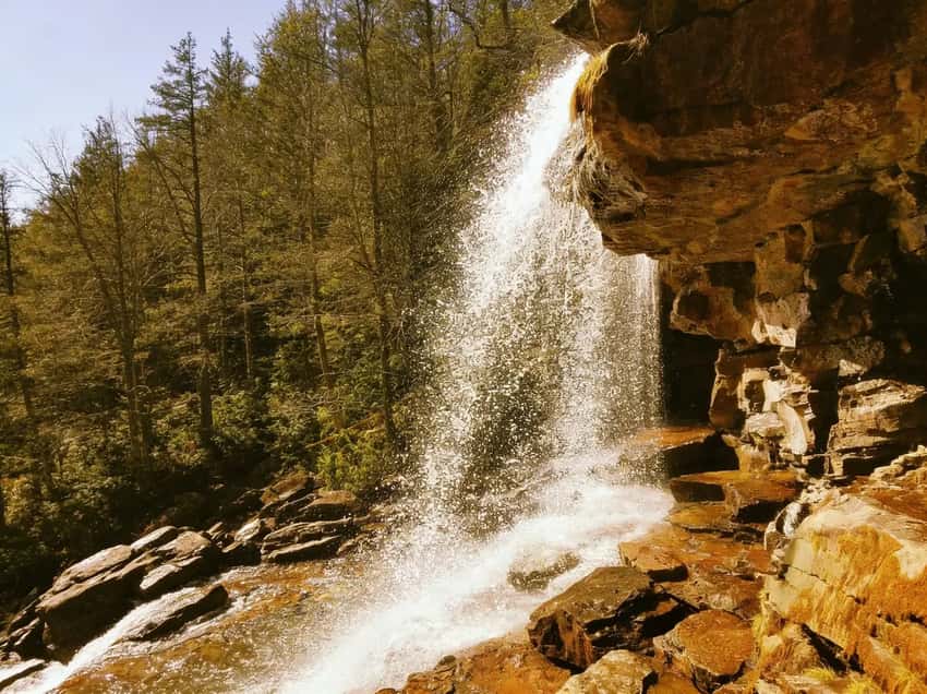
Glen Onoko Falls drops through a series of cascades in a gorge above Jim Thorpe in the Lehigh Gorge region. The old trail gained 600 feet of elevation in less than a mile by scrambling directly up alongside and sometimes across the waterfall faces.
There were no steel staircases, no railings, and no infrastructure of any kind. Wet rock, steep drops, and a scramble route that was one bad step from a serious fall.
The waterfalls themselves are what made this trail famous and what made it lethal. The same water spray that made the photos worth taking kept the rocks permanently slick. The same dramatic exposure that gave the hike its reputation meant there was no margin for a misplaced foot.
The Fatality Record
Since 1977, at least eight people died on the Glen Onoko Falls Trail. Between 2008 and 2019 alone, the Game Commission recorded 14 medical emergencies involving 18 visitors, including 7 deaths. The incidents were not limited to inexperienced hikers making obvious errors, the terrain was dangerous enough to catch experienced people too.
The Rescue Cost
Carbon County’s volunteer fire departments and emergency response teams conducted dozens of rescues over the trail’s history. The terrain made extractions extremely difficult.
Responders regularly had to rappel down cliff faces to reach injured hikers. Each rescue consumed significant volunteer resources and put the responders themselves at risk. The Game Commission ultimately determined that keeping the trail open was no longer defensible.
The Closure
The Pennsylvania Game Commission closed the Falls Trail permanently on May 1, 2019. Signs are posted at all access points and throughout the trail system. Enforcement is active.
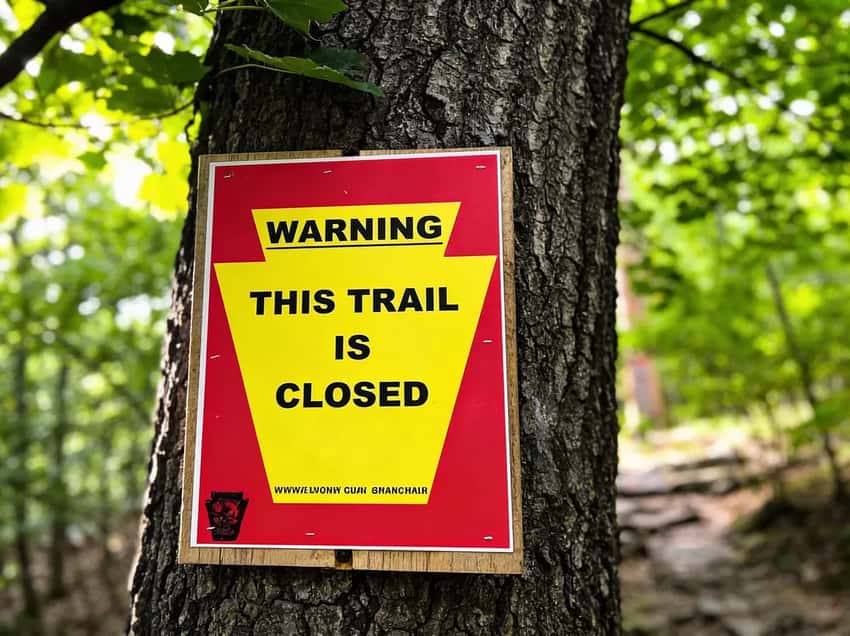
The Falls Trail has been closed since May 2019. Fines are enforced.
The Fines: What Happens If You Go Anyway
Trespassing fines run $100 to $200 and are issued by the Pennsylvania Game Commission, which actively patrols the area. The fine amount increases for criminal trespass or if a rescue operation is required because of your decision to enter.
Beyond the fines: the trail has continued to deteriorate since closure. Unsecured rock faces, no cleared path, and increasingly unstable terrain around the waterfall sections make it more dangerous now than it was when it was open. The photo opportunities that made people want to go are largely inaccessible without the technical gear and skills to navigate a deteriorated scramble route.
The people who died doing this hike were not all inexperienced. The terrain is the problem, not the skill level of the visitors. That situation has not improved.
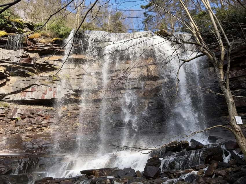
Glen Onoko Falls before the permanent closure.
The Land Transfer: What’s Coming
In late 2024, Governor Shapiro proposed transferring 391 acres including the Glen Onoko Falls area from the Pennsylvania Game Commission to DCNR for incorporation into Lehigh Gorge State Park. The Pennsylvania Board of Game Commissioners approved the transfer in April 2025.
What this means practically: DCNR has the resources, mandate, and expertise to build a proper trail infrastructure in a way the Game Commission does not. The expectation, though no plans have been officially released, is something similar to what Ricketts Glen has: steel staircases, railings, proper drainage, and maintained footing on the steep sections.
What it does not mean: an imminent reopening. Land transfers require legal completion, then planning, then environmental review, then construction. The most optimistic realistic estimate is several years. There is no announced timeline.
Check the PA Governor’s newsroom and DCNR Lehigh Gorge updates for any new developments on the transfer and trail timeline.
The Legal Alternative: Glen Onoko Overlook Trail
What It Is
A separate, open trail that ascends above the closed Falls Trail area to a rocky hilltop overlook with views over Jim Thorpe and the Lehigh River valley. It does not access the waterfall faces of the closed Falls Trail. It offers completely different scenery: ridge views and the town below rather than the close-up waterfall gorge.
This is not a consolation prize for missing the falls. It is a legitimately strenuous hike with what the Falls Trail never had, a clear ridge view at the end.
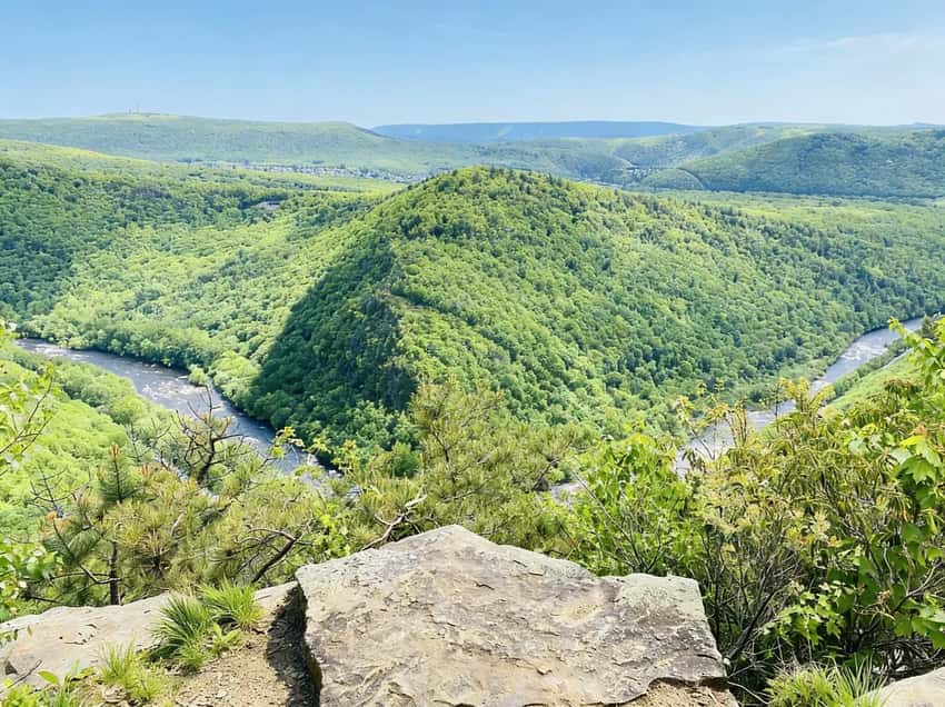
The Overlook Trail looking down on Jim Thorpe and the Lehigh River.
The Route
- Start: Glen Onoko Access parking lot, Lehigh Gorge State Park. From Jim Thorpe town, take Main Street to Lehigh Street and follow the access road to the lot.
- Navigation: Go under the bridge, follow the path along the river, then turn uphill (right) before reaching the closed Falls Trail area. The turn is marked. Do not continue straight toward the Falls Trail signs.
- Distance: 3.6 miles loop, with shorter out-and-back options.
- Elevation: Significant, you are climbing the full ridge above the gorge.
- Difficulty: Hard to strenuous. This is not a flat trail or a gentle walk.
What the Hike Is Actually Like
The Overlook Trail gains elevation quickly from the parking lot. The first section is wooded and steep, with loose rock and root-covered tread similar to many Poconos ridge climbs. There are no staircases, this is a natural trail maintained by the state, not the engineered infrastructure the Falls Trail lacked.
The terrain eases as you approach the ridge. The summit area is an open rocky outcrop with unobstructed views south and west over Jim Thorpe, the Lehigh River, and the gorge. On clear days the view extends well down the valley. The town of Jim Thorpe below, with its Victorian architecture and steep hillside layout, is more visible from here than from any vantage point in the town itself.
The descent follows the same ridge back or loops through the wooded ridge section. The loop is more satisfying than an out-and-back but adds length. Either way, expect your legs to feel the elevation on the way down.
Ticks: The wooded ridge sections have tick activity from April through October. Check thoroughly after hiking. The lower sections near the river corridor and the brushy ridge transitions are higher-risk areas.
Cell service: Drops on the ridge. Download a map before leaving the parking lot.
Who the Overlook Trail Is For
Hikers who want a genuine strenuous workout with a clear payoff view. Anyone curious about the area who wants to visit legally while the Falls Trail remains closed. Photographers who want to shoot Jim Thorpe and the gorge from elevation rather than the old close-up waterfall angles.
It is not for people who specifically want to see the waterfalls up close. That is not what this trail offers.
The Other Open Options
D&L Trail Through Lehigh Gorge
The D&L Trail runs through the gorge on crushed stone alongside the Lehigh River, 26 miles one-way from White Haven to Jim Thorpe.
It is flat, open for hiking and biking, and passes the Turn Hole Tunnel (an abandoned railroad tunnel cut through the gorge wall) just south of the Glen Onoko access area. If you park at the Glen Onoko lot, the D&L is immediately accessible and represents the easiest option in the area.
Lehigh River Access
The river at the Glen Onoko access point is open for kayaking, fishing, and river access. Whitewater rafting is available through commercial operators in Jim Thorpe.
Photography Tips: Glen Onoko Overlook Trail
Ridge View Landscape: The summit area provides expansive overlook photography. Use a wide-angle lens (16-35mm) to capture Jim Thorpe, the Lehigh River, and the gorge in context. The town’s Victorian architecture is surprisingly visible from elevation:mid-telephoto (50-85mm) lenses can compress the scene and emphasize distant features.
Morning Light Optimal: Shoot the overlook in early morning when the town below is still partially shadowed and the gorge walls catch directional light. This creates dimension and depth that midday flat light cannot.
Gorge Perspective: Position yourself to frame the closed Falls Trail area below from the Overlook Trail elevation. This creates context about why the falls became inaccessible:the dramatic exposure becomes visually apparent.
Seasonal Color: Fall foliage in the gorge (mid-October) combined with the ridge views creates compelling landscape photography. The contrasting evergreen hemlock against deciduous fall color is distinctive to the Lehigh Gorge.
Cloud Dynamics: Overcast days reduce glare and provide even exposure across the broad vista. Evening light (after 4 PM) can provide dramatic backlighting against valley clouds.
Avoid the Closed Falls Trail Angle: Do not attempt to photograph the closed Falls Trail area up close. The closure is enforced and the deteriorated trail presents genuine hazard to photographers who might venture off the Overlook Trail path to get “that shot.”
Parking and Logistics
The Glen Onoko Access parking lot (Lehigh Gorge State Park) is at the end of the access road from Jim Thorpe. From town: Main Street to Lehigh Street, follow signs for Lehigh Gorge State Park. The lot is large but fills quickly on weekends, D&L Trail cyclists and river users share it with hikers.
Pit toilets are available at the parking lot. No other facilities on site.
FAQ
Is Glen Onoko Falls open? The Falls Trail is permanently closed since May 1, 2019. The Glen Onoko Overlook Trail and D&L Trail remain open and legal.
Why was it closed? Eight fatalities and numerous serious injuries due to dangerous terrain, steep scrambling on permanently wet, moss-covered rock faces with no safety infrastructure.
What are the fines for trespassing? $100 to $200 for standard trespass, higher if a rescue operation is required. The Game Commission enforces this actively.
What does the Overlook Trail offer? A strenuous 3.6-mile hike with a ridge-top view over Jim Thorpe and the Lehigh River. Different experience from the old Falls Trail, a view hike rather than a waterfall scramble.
Will the Falls Trail reopen? Possibly, with rebuilt infrastructure. The land transfer to DCNR was approved in April 2025. No construction timeline has been announced. Realistically, several years.
Is the D&L Trail open near Glen Onoko? Yes. The flat rail-trail is open for hiking and biking and passes through the Glen Onoko access area.
Glen Onoko is the cautionary story of what happens when a genuinely dangerous trail outgrows its infrastructure. The Overlook Trail is the right place to experience the ridgeline above Jim Thorpe legally while the Falls Trail situation resolves.
For the broader Lehigh Gorge State Park picture, including the D&L Trail through the gorge, the park guide covers everything that is open and worth doing right now. The Lehigh Valley region guide covers Jim Thorpe and what else the area offers for a full-day or overnight trip.