The Pinnacle Trail: Best View in Pennsylvania (9-Mile Loop Guide)
270-degree views over the Lehigh Valley, two rocky overlooks, and 1,300 feet of classic AT terrain. Here is how to hike The Pinnacle the right way.
The Pinnacle is the best view in Pennsylvania. That is not a marketing line. It is a geological fact. The trail ends at a flat quartzite boulder field at 1,635 feet, shaped like the tip of a wedge into the valley, and from that point you have 270 degrees of unobstructed sky: the Lehigh Valley below, the Blue Mountain ridge running to the horizon in both directions, and on clear days, a long look deep into the Poconos.
Nothing in the state gives you that combination of scale, accessibility, and earned reward on a single day hike.
Key Takeaways
- Navigation: Park at the Hamburg Reservoir lot (Google Maps | Apple Maps). GPS: 40.5658, -76.0342. This is the only legal access point and is full by 8 AM on weekends.
- The Reward: Widely considered the best view in Pennsylvania, offering a 270-degree panorama at 1,635 feet.
- Terrain: A strenuous 9-mile loop on the Appalachian Trail, featuring classic “Rocksylvania” boulder hops and a 1,300-foot gain.
- Safety Insight: Use high-traction boots with ankle support, the quartzite ridge is unforgiving and can roll an ankle in a split second.
You earn the view. The 9-mile counter-clockwise loop from Hamburg Reservoir climbs 1,300 feet through some of the rockiest terrain on the Appalachian Trail in Pennsylvania.
The stretch between Pulpit Rock and The Pinnacle is a genuine Rocksylvania boulder hop, quartzite slabs, ankle-twisting transitions, and a ridge that demands you watch your feet more than anything above them. Your ankles will be angry. The view makes it easy to forget that.
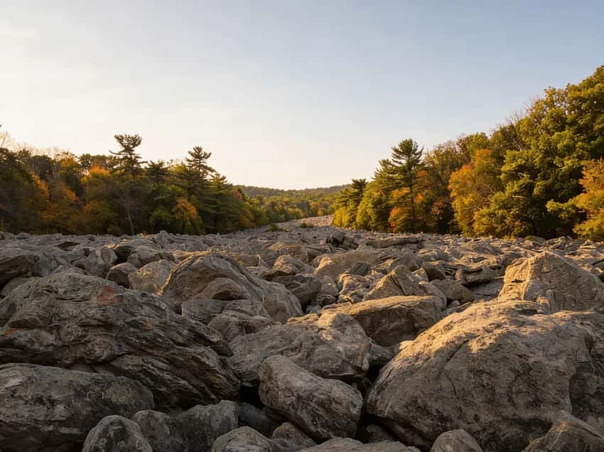
The ridge section between Pulpit Rock and The Pinnacle. Classic PA AT terrain.
Parking at Hamburg Reservoir (Plan This First)
The trailhead is at the end of Reservoir Road in Hamburg, PA 19526.
GPS: 40.5658° N, 76.0342° W
The lot holds 30 to 40 cars and costs nothing. On any nice weekend from April through November, it fills by 8:00 AM. Arrive after nine and you will be parking on the shoulder of Reservoir Road, legal, common, and annoying. Plan around it.
There is a small Appalachian Trail shelter near the trailhead with a composting toilet. No water on the trail. Fill up at home or at a gas station in Hamburg before you drive in, the ridge is dry the entire way.
The Route: Counter-Clockwise From Hamburg Reservoir
Most hikers do this loop counter-clockwise for a simple reason: you get the hard climbing done on fresh legs, and you finish with a long, gentle descent on the blue-blazed Pinnacle Trail when your body is already spent. Going clockwise reverses that logic and makes the final miles miserable.
Hamburg Reservoir to Pulpit Rock, 2.5 Miles, 1,000 Feet of Gain
From the parking lot, a short gravel road walk leads to the white blazes of the Appalachian Trail through Weiser State Forest.
The moment you hit the AT, the climbing starts. It does not ease in gently. The first two miles are steep, rocky, and relentless, you are gaining most of your elevation before you reach the first overlook. Trekking poles earn their keep here.
Stiff-soled hiking boots are mandatory. Trail runners are a real ankle risk on the wet quartzite.
At mile 2.5, the ridge widens into Pulpit Rock.
Pulpit Rock, Mile 2.5
Pulpit Rock is a rocky outcrop that juts from the ridge and looks straight down into the Hamburg Reservoir. The view is good. It is also a warm-up act.

Pulpit Rock at mile 2.5, a good rest stop, but keep moving.
Pulpit Rock is a prime hawk-watching spot in October and November, when broad-winged and sharp-shinned hawks migrate south along Blue Mountain. Sit here long enough on a good fall day and you will watch raptors gliding at eye level below you. Worth the stop.
Do not stop long. The Pinnacle is two miles ahead and considerably better.
Pulpit Rock to The Pinnacle, 2 Miles, 300 More Feet
This is the Rocksylvania stretch. The trail follows the ridge crest between the two overlooks and it is a boulder field the entire way. The quartzite here is pale gray-blue and has been heaving out of the ridge for centuries, it makes for slow going.
Most hikers average under one mile per hour through this section. Watch your footing, use your poles, and do not rush.
The Hawk Mountain Sanctuary sits visible on the ridge to the east during this stretch, a private sanctuary with its own trails and admission fee. The Pinnacle itself is free public land managed through the AT corridor. You do not need to pay to reach it.
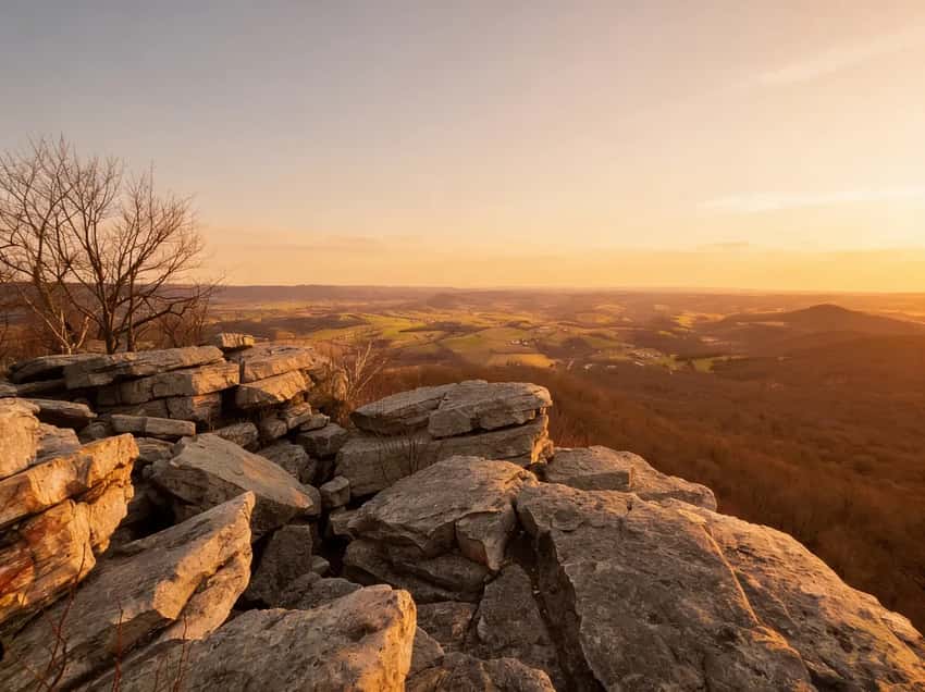
The Pinnacle, Mile 4.5
The flat boulder field appears without ceremony. One moment you are picking through rocks on the ridge, and the next you are standing on a wide platform of quartzite with nothing in front of you but 270 degrees of Pennsylvania valley.
The Pinnacle at mile 4.5. The Lehigh Valley below, Blue Mountain to the horizon.
The view faces south and west. The Lehigh Valley spreads out below in both directions. In October, the foliage in the valley turns while the ridge stays green a few weeks longer, you get both colors at once from up here. In winter, with cold air and low humidity, you can see distances that are completely invisible in summer haze.
Eat lunch here. Take the photos. Watch the hawks. Then get up and move, the hard part is over, but you still have four and a half miles of trail back to your car.
The Pinnacle to Hamburg Reservoir, 4.5 Miles, Mostly Downhill
Pick up the blue-blazed Pinnacle Trail heading north. It follows an old fire road grade back down to the reservoir and is a complete contrast to the AT sections above: wide, gradual, significantly less rocky, and shaded for most of its length. It is the payoff for having done the hard climbing first.
The descent is long. Four and a half miles feels like more when your legs are already worked. Take it easy on the knees on the steeper initial sections. By the time the trail levels out near the reservoir, you have earned it.
Safety and Hazards
The rocks. The ridge section between the overlooks is brutal on ankles. One wrong step on a loose quartzite slab and you are rolling an ankle or going down. Steer clear of trail runners unless you have strong ankles and experience on rocky technical terrain. Sturdy hiking boots with ankle support are the right call.
The edge. The Pinnacle has sheer drop-offs on its southern face. The rocks are slippery when wet. Keep dogs and kids well back from the lip, there is no railing and the ledge drops hard.
Ticks. The brushy lower sections of the AT approach and the fire road descent are heavy tick habitat from May through October. Do a full body check after the hike. Long sleeves and pants are not overkill on this trail.
Snakes. Eastern Copperheads and Timber Rattlesnakes are common on the sunny quartzite outcrops, especially from May through September. Watch where you put your hands during any scrambling and give snakes space if you encounter one cooling off on the trail.
Cell service. It drops to spotty or nothing once you gain the ridge. Download offline maps before you leave the parking lot.
Best Time to Hike The Pinnacle
Fall (September through early November): Peak season. The foliage from the overlooks is world-class, and it is also peak hawk migration, you may see thousands of raptors per day on good wind days in October. The parking lot will be full before 8:00 AM most October weekends.
Winter (December through February): The view is better in winter. Colder air, lower humidity, and no leaf cover mean visibility that summer hikers never see. You will likely have the ridge to yourself.
Microspikes are mandatory if there is any snow or ice on the quartzite, those rocks become genuinely dangerous when frozen. No exceptions.
Spring (March through May): Mud season on the descent trail. The fire road section gets soggy. Ticks become active in late April. The AT is open and hikeable, but come prepared for wet conditions.
Summer: Hot and exposed on the ridge. The quartzite radiates heat. Start before 7:00 AM and plan to be off the ridge before noon if temperatures are above 80°F.
What to Bring
A 9-mile strenuous loop with no water on trail and exposed ridge sections requires more than a typical day hike:
- Water: Minimum 2 liters per person. More in summer. There is no water source on the trail.
- Hiking boots with ankle support: Not a recommendation. A requirement on this terrain.
- Trekking poles: Genuinely useful on the boulder hop and on the descent.
- Tick kit: Tweezers, tick remover tool. Check after you’re done.
- Microspikes (October through March): If there is any chance of ice on the ridge.
- Snacks: 4 to 6 hours on trail burns real energy. Pack accordingly.
- Offline maps: Downloaded before you lose cell coverage on the ridge.
- Blaze orange (October through December): Orange rules apply on Weiser State Forest land during hunting season. A vest or hat is cheap insurance.
FAQ
How hard is The Pinnacle hike? Strenuous. 9 miles and 1,300 feet of elevation gain, with a rocky ridge section that requires careful footing. Comparable in difficulty to the upper sections of Ricketts Glen, but longer. Not appropriate for beginners or anyone not comfortable on rocky, uneven terrain.
What time should I arrive for parking? Before 8:00 AM on weekends from April through November. The lot holds 30 to 40 cars and fills reliably on any day with decent weather. Weekday hikers rarely have an issue.
Can I bring my dog? Yes, on leash. Dogs handle the AT sections well but may need assistance on a few of the larger quartzite boulder transitions on the ridge. The summit is open and exposed, keep dogs back from the drop-off edge.
Is the trail open in winter? Yes, but microspikes are required if there is any ice or snow. The quartzite becomes extremely slippery when frozen. The bonus: winter visibility from The Pinnacle is the best of any season.
Is there a shorter option? You can do an out-and-back to Pulpit Rock only (5 miles, 1,000 feet gain), but you miss The Pinnacle entirely. A better shortcut is hiking the ridge section out-and-back from the lot to The Pinnacle via the AT, roughly 9 miles either way, so there is not truly a short version of this loop.
Where exactly is The Pinnacle? The Pinnacle is on the Appalachian Trail in Berks County, accessed from the Hamburg Reservoir trailhead (GPS: 40.5658° N, 76.0342° W). It is not inside Hawk Mountain Sanctuary, which is a separate, paid private sanctuary nearby.
The Pinnacle is the right answer every time someone asks where the best view in Pennsylvania is. Nine miles is a full day. Pack accordingly, arrive early, and give yourself time at the top.
For more Lehigh Valley and Blue Mountain trails, the region guide covers the ridgeline options within an hour of Hamburg. And if you are building a multi-day trip around the Appalachian Trail in Pennsylvania, the section from the Delaware Water Gap through the Lehigh Valley is some of the finest AT terrain in the state.