Turkey Path: Down is Easy, Up is Hell
800 feet down into the PA Grand Canyon is easy. The climb back out is the hardest mile on the eastern rim. Here's what to expect, how to prepare, and which side of the canyon to start from.
The Turkey Path at Leonard Harrison State Park is a trap. It lures you in with a deceptively easy descent on wooden decks and switchbacks, offering good views of waterfalls on the way down.
You reach the bottom, stand at the Pine Creek Rail Trail, and look for a bridge to cross the creek. There is no bridge.
So you turn around. And that is when it hits you: you have to climb 800 feet in one mile to get back to your car.
Down is easy. Up is hell.
Key Takeaways
- Navigation: Park at the Leonard Harrison State Park main lot (Google Maps | Apple Maps). GPS: 41.6967, -77.4641. The trailhead is behind the visitor center.
- Physical Challenge: Deceptively easy 800-foot descent. The return climb is a brutal mile, comparable to an 80-story building.
- Parking Warning: The Leonard Harrison lot is at capacity by 10:00 AM during fall peak. Arrive early for the best gorge views.
- Safety Insight: The wooden decks and stairs are permanently wet from waterfall spray. Boots with lugged soles are mandatory.
- Winter Closure: The trail is strictly closed from late November to mid-April due to dangerous ice buildup on the gorge walls.
Leonard Harrison vs. Colton Point: Which Turkey Path?
There are two Turkey Path trails, one on each rim of the canyon. They do not connect without crossing Pine Creek, which is not safely fordable at normal flow levels.
Leonard Harrison (East Rim), This Guide
The popular side. Developed infrastructure: wide trails, wooden observation decks, stairs with handrails. Better views of Little Four-Mile Run falls.
Flush toilets and a visitor center at the top. Expect crowds on weekends and peak fall foliage weeks.
Colton Point (West Rim), The Hiker’s Side
The same 800-foot descent on the opposite rim, with a different character. Narrow paths, steep switchbacks, fewer railings, primitive facilities (pit toilets). You are unlikely to see many other people on Colton Point on a weekday. If you know what you are getting into and want to be alone in the canyon, the west rim delivers.
No bridge at the bottom. Do not attempt to wade across Pine Creek in high water, the current is significantly stronger than it looks from the bank, especially in spring.
The Trail
The Descent, 1 Mile, 800 Feet Down
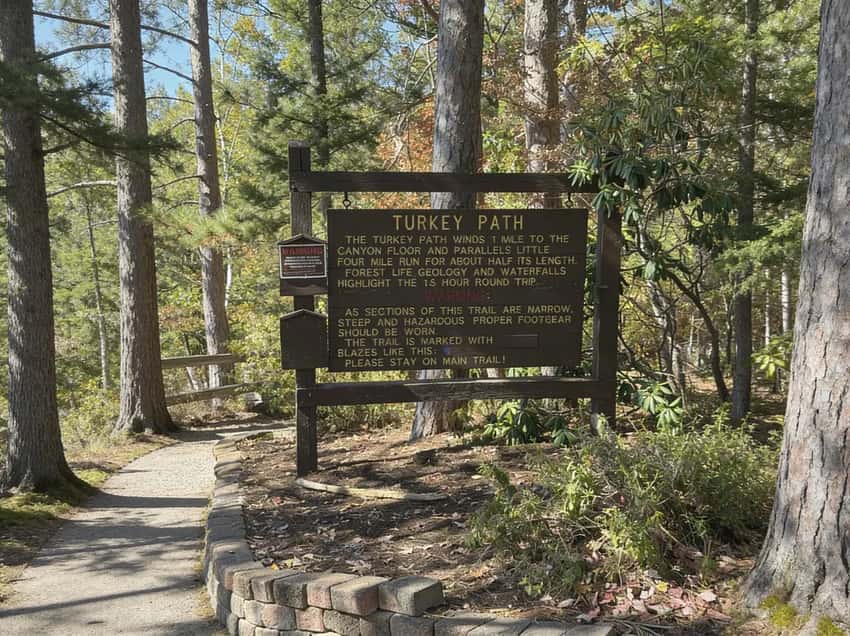
The trail starts near the Otter View overlook at Leonard Harrison. The descent begins immediately on a mix of gravel switchbacks and wooden staircases. The trail is blazed yellow and signed as “Most Difficult”, accurate, though the difficulty is concentrated in the return climb rather than the descent.
Roughly halfway down you meet Little Four-Mile Run. The trail parallels the stream from this point, passing a series of cascades. Wooden viewing decks at the Upper and Lower Falls provide the best camera positions.
The canyon walls rise on both sides as you drop. The air gets cooler and damper.
The descent takes 30 to 45 minutes at a moderate pace.
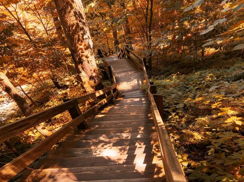
The wooden staircases make the descent manageable. They are wet year-round from waterfall spray.
The Bottom, Pine Creek Rail Trail
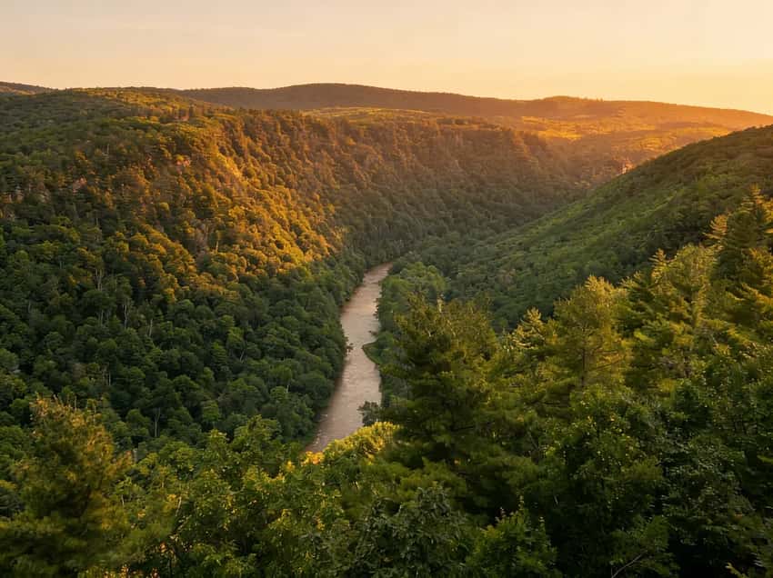
The trail deposits you onto the Pine Creek Rail Trail, the 62-mile crushed-stone corridor for cyclists. It is flat, quiet, and gives you the view most people miss: looking up at the canyon walls you just descended. The scale of the gorge is more visible from the bottom than from any of the descent overlooks.
There are benches here. Sit. Drink your water.
Eat something. You are burning more on the climb out than you burned coming down, and the first quarter mile of the ascent is the steepest.
If you want more time at the bottom, walking a mile south or north on the Pine Creek Rail Trail and back is an easy addition that makes the overall trip feel less like a single turnaround point. There is nothing wrong with sitting at the creek for twenty minutes before you go back up.
The “Most Difficult” rating is fair. The difficulty is almost entirely on the return climb.
The Climb, 1 Mile, 800 Feet Up
This is the entire hike. You gain 800 feet of elevation in a single mile. For reference, that is approximately the stair equivalent of climbing an 80-story building. Most of the gain is frontloaded, the first quarter mile back up is the most relentless section.
The strategy: do not sprint the first quarter mile because you feel good leaving the bottom. Set a pace you can sustain for 45 to 90 minutes depending on your fitness. Use the switchbacks to breathe. Stop at the wooden deck overlooks on the way up, they are there, they give you a reason to pause, and pausing is not failure.
The hikers who were talking on the way down are usually quiet on the way up. This is normal.
Waterfalls
The main falls along Little Four-Mile Run are the reason most people make this hike. The Upper Falls and Lower Falls are the primary targets, both accessible from the wooden observation decks on the descent. The Upper Falls is taller. The Lower Falls produces a better photograph because the deck provides a cleaner angle to the full drop.
Water volume is highest in spring from snowmelt and drops through summer. By August in a dry year the flow is noticeably reduced. The falls are still present, they are fed by springs as well as precipitation, but spring is unambiguously the best season for water volume.
The gorge depth becomes clear once you are partway down the descent.
Parking and Logistics
The main parking lot at the Leonard Harrison State Park entrance is large and paved. It fills on summer weekends and during peak fall foliage in October. If the main lot fills, overflow parking is available at the park but adds a short walk.
GPS: The park entrance is on Route 660 in Wellsboro, PA. Driving directions to Leonard Harrison State Park will take you to the correct lot.
Flush restrooms and a visitor center are at the top, near the parking lot. There are no facilities at the canyon bottom.
Seasonal Closure
The Turkey Path closes from the Wednesday before Thanksgiving through the second Friday in April each year. The closure is due to ice, waterfall spray freezes on the stairs and wooden decks, making the descent and ascent genuinely dangerous.
Check the DCNR Leonard Harrison alerts page before driving out. The trail also closes intermittently due to storm damage and landslides, which occur on this slope with some regularity.
Safety
Physical exhaustion. The most common hazard on this trail is not the terrain, it is arriving unprepared for the elevation gain. People who underestimate the return climb arrive at the bottom with insufficient water and inadequate rest before the ascent. Bring more water than you think you need. Rest at the bottom before you start up.
Slippery decks. The wooden stairs and observation decks are permanently wet from waterfall spray. They are slick even in summer when the air temperature is warm. Hiking boots with grip are the correct footwear. Sandals and flat-soled shoes go badly here.
Timber Rattlesnakes. Present in the canyon from late April through September. They move toward the creek to cool down in warm weather. Watch where you step on the trail and give any snake you encounter space to move. Do not reach into rock crevices or brush when stepping off the trail.
Ticks. The forested descent corridor and the brushy sections near Pine Creek are tick habitat from April through October. Check thoroughly after the hike.
Best Time to Visit
Spring (April through May): Waterfalls at peak volume from snowmelt. The canyon is green and cool. This is the best season for the falls. Trail opens mid-April most years, check DCNR for the exact reopen date.
Fall (October): The PA Grand Canyon is one of the best fall foliage destinations in Pennsylvania. The canyon walls in color, viewed from the descent overlooks or from the bottom looking up, are genuinely worth the trip. October weekends are the most crowded of the year.
The parking lot is at capacity by 10 AM on peak foliage Saturdays. This is also the best season for the climb temperature-wise, cool enough to make the ascent comfortable.
Summer (June through August): The canyon is humid in July. The ascent in high humidity is harder than the same grade in cool weather. Go early in the morning. Mid-day in July with a noon ascent is the worst combination this trail offers.
Winter: Closed. The closure dates are firm and the reason for them is real.
What to Bring
- Water, minimum 2 liters per person. The climb out requires more hydration than you used getting down.
- Hiking boots with ankle support and grip, mandatory. The wet wooden decks and steep descent surfaces do not tolerate flat-soled footwear.
- Snacks, something to eat at the bottom before the ascent. The caloric demand of the return climb is real.
- Tick kit, May through October, check after.
- Trekking poles, optional but useful on the ascent for people with knee concerns.
FAQ
How hard is the Turkey Path really? The descent is moderate, steady downhill on maintained trails and wooden stairs. The ascent is strenuous. Gaining 800 feet per mile is the same grade as Ricketts Glen’s Glen Leigh section, except this is all in one continuous climb with no flat sections to recover.
Is there a bridge at the bottom? No. You cannot cross Pine Creek to reach the Colton Point Trail or the other side of the canyon without a planned watercraft crossing or a very long drive around.
When does the trail open after winter? The second Friday in April most years. Check DCNR alerts for the exact date each spring.
How are Timber Rattlesnakes managed on the trail? They are not, the trail passes through their natural habitat. Standard protocol: watch where you place your feet and hands, give snakes space, and do not attempt to handle or move them.
What is the Pine Creek Rail Trail like at the bottom? A 62-mile flat, crushed-stone corridor. Most users are cyclists. You can walk north or south along it before the return climb without any additional permit or fee.
The Turkey Path is the most physically honest hike in the PA Grand Canyon region. It tells you exactly what it is, a short, brutal descent and an equally brutal return, and delivers on both.
For the broader PA Grand Canyon region guide covering the Colton Point trails, Pine Creek Rail Trail logistics, and what else is worth building a trip around in Tioga County, the region guide covers the full picture.