Delaware Water Gap: 70,000 Acres, Zero Parking
Mt. Tammany, Raymondskill Falls, and the Delaware River. Here's how to hike Delaware Water Gap without the crowds.
Key Takeaways
- The “Exit 1” Parking Hack: If the Dunnfield Creek lots for Mt. Tammany are full by 9:00 AM, continue to the Kittatinny Point Visitor Center (Exit 1). It is a 10-minute walk back to the trailhead but avoids heavy highway shoulder parking fines.
- Major Closure Alert: Dingmans Falls is closed until Spring 2026 for bridge and boardwalk reconstruction. Use Hornbecks Creek as a quieter, unmarked alternative for waterfall views.
- Raymondskill Strategy: Arrive before 9:00 AM for the state’s tallest waterfall. If the main lot is full, check the Hackers Trailhead lot just down the road as your primary secondary option.
- NJ vs PA Side: Head to the New Jersey side for strenuous hands-on rock scrambling (Mt. Tammany). Stick to the Pennsylvania side for the tallest waterfalls and more moderate Appalachian Trail vistas (Mt. Minsi).
- Traffic Avoidance: Avoid I-80 Westbound on Friday afternoons and Eastbound on Sunday afternoons to sidestep 30-minute gridlock delays. Download offline maps before arrival due to spotty gorge reception.
Delaware Water Gap National Recreation Area is 70,000 acres of river and ridges straddling Pennsylvania and New Jersey. It’s the largest National Park Service site in the Northeast, and one of the most crowded.
On summer weekends, the parking lot at Mt. Tammany fills by 8:30 AM. I-80 through the Gap turns into a parking lot. The beaches charge $10 per car (proposed increase to $20 in 2025).
But here’s the thing: if you go on a weekday, arrive before dawn, or hike the quieter trails, Delaware Water Gap delivers dramatic river views, steep scrambles with hand-over-hand climbing, and some of Pennsylvania’s tallest waterfalls.
This isn’t a wilderness escape, it’s a logistical puzzle. Learn the timing, know the parking tricks, and you’ll find world-class hiking in a 70,000-acre park that feels far less crowded than its reputation suggests.
Visit the National Park Service site for trail closures and check AllTrails for current conditions.

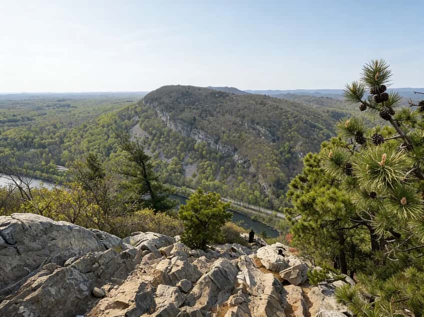
The Gap - where the Delaware River cuts through the ridge
What’s Open (and What’s Not)
❌ Dingmans Falls is CLOSED
The second-highest waterfall in Pennsylvania (130 feet) is closed until Spring 2026 for a major bridge replacement and trail reconstruction. The access road, visitor center, and boardwalk are all off-limits. Don’t drive there hoping to sneak a peek.
- Alternative: Try Hornbecks Creek (trail is unmarked, but the waterfalls are great and less crowded).
✅ Raymondskill Falls is Open
Pennsylvania’s tallest waterfall (150-178 feet across three tiers) is open. The trail is short (0.3 miles one-way) but steep and slippery.
Trail Details:
- Distance: 0.3 miles one-way
- Elevation: 150 feet steep descent
- Time: 10-15 minutes down, 15-20 minutes return (steep climb back)
- Surface: Dirt, rocks, roots, very slippery when wet
- Difficulty: Easy to moderate distance, but the steepness makes descent tricky
What to Expect:
- Steepness Reality: Don’t underestimate the 150-foot descent in 0.3 miles. The return is a leg burner
- Crowds: Busy on weekends. Early morning (before 8 AM) is much quieter. Most visitors only spend 30 minutes here
- Water Safety: This is where people slip and die. The rocks are polished smooth and slippery. Wear proper hiking boots with good grip
- Spray Zone: In spring, the mist from three tiers of falls reaches the lower observation area. Bring waterproof gear
- Photography: The three-tiered cascade is photogenic from the base. Spring (April-May) has the most water. Late afternoon (4-6 PM) has golden hour light on the falls
⚠️ Warning: Swimming and wading are strictly prohibited within 50 feet of the falls. People have died slipping on the rocks here. Rangers patrol this area regularly and will issue citations.
Mt. Tammany (The Icon)
The Hike
- Distance: 3.5-mile loop (Red Dot up, Blue Dot down)
- Elevation Gain: 1,200 feet in 1.5 miles
- Difficulty: Strenuous. The Red Dot trail involves scrambling with your hands. It is steep, rocky, and exposed to the sun. This is not a casual walk.
- The Reward: The iconic view looking down at the Delaware River cutting through the ridge.
- Trailhead: Dunnfield Creek Parking Area (NJ side, off Route 27)
- Best Time: Spring for waterflow (April-May), fall for foliage (September 25-October 15), weekday mornings for solitude
What to Expect
- Steepness Reality: 1,200 feet in 1.5 miles = relentless uphill. Average pace is 1 mph due to the grade and scrambling. This is an intense climb
- Hand-Over-Hand Scrambling: The Red Dot Trail requires literal scrambling with your hands, especially in the upper half. Exposure is real but not extreme (5-15 foot drops, not cliffs)
- Parking Reality: Dunnfield Creek lot fills by 8:30 AM on weekends. Arriving after 9 AM means overflow parking, dangerous highway shoulders, or no parking
- Time Reality: 3.5 miles takes 2.5-4 hours for fit hikers depending on scramble difficulty and photo stops. Descent via Blue Dot is easier on the legs but still technical (rocky, rooted)
- View Quality: The vista from the summit is the signature Delaware Water Gap scene, 1,600+ feet looking down at the Delaware River cutting through Kittatinny Ridge. On clear days, visibility is excellent
- Trail Condition: Rocky, rooted, steep. Hiking boots essential (no sneakers). The Red Dot scramble sections become treacherous when wet
- Crowds: Busy on weekends and fall foliage. Weekday mornings before 8 AM are quieter
- Water: Streams available on descent. Carry 2+ liters for the climb (no water on Red Dot)
- Fitness Level: Strenuous. This is one of PA’s harder day hikes. Not for beginners or slow hikers
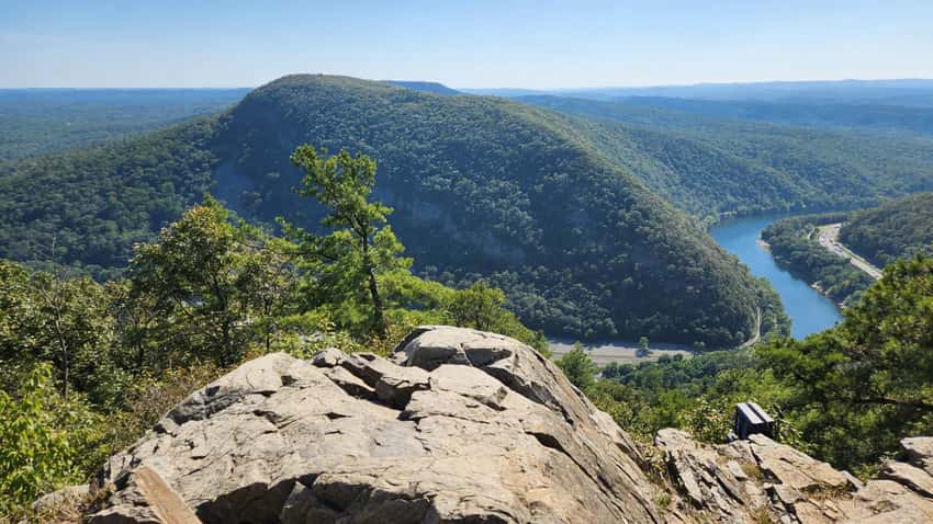
A wider view of the Gap from the Mount Tammany summit
The Parking Strategy
The Dunnfield Creek parking lot fills by 8:30 AM on weekends. If you arrive later:
- You might find a spot at the Kittatinny Point Visitor Center (if open)
- You’ll have to walk 10+ minutes to the trailhead
- Overflow parking often spills onto the I-80 shoulder, which involves a dangerous highway crossing
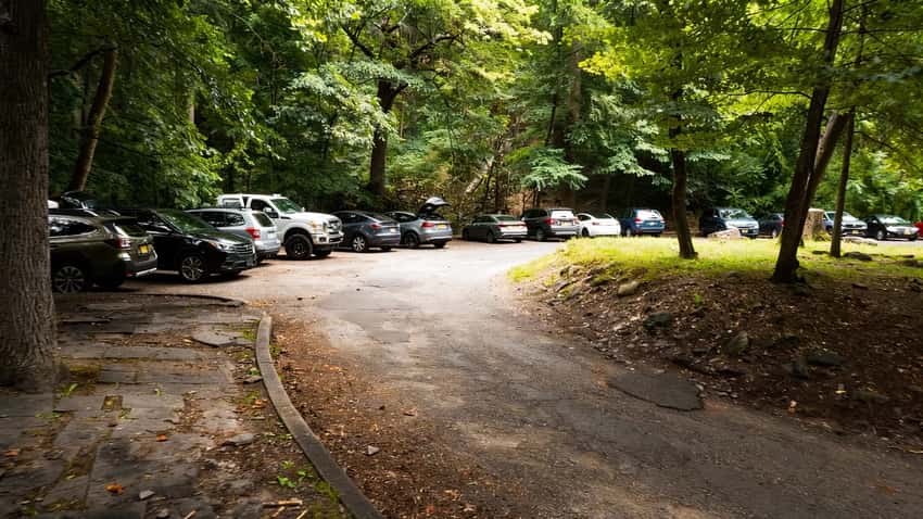
The Dunnfield Creek lot fills by dawn on summer weekends
Best Advice: Arrive by 7:30 AM or go on a Tuesday. Alternatively, hike Mt. Minsi on the PA side, it offers a similar view (looking at Tammany) but is slightly easier and is on the Appalachian Trail.
Dunnfield Creek Trail
After descending Mt. Tammany via the Blue Dot Trail, you’ll follow the Appalachian Trail alongside Dunnfield Creek back to the parking lot. This 3.5-mile section features cascades and stream crossings.
The creek is a designated Wild Trout Stream. For a longer hike, continue to Sunfish Pond (a glacial lake) before returning.
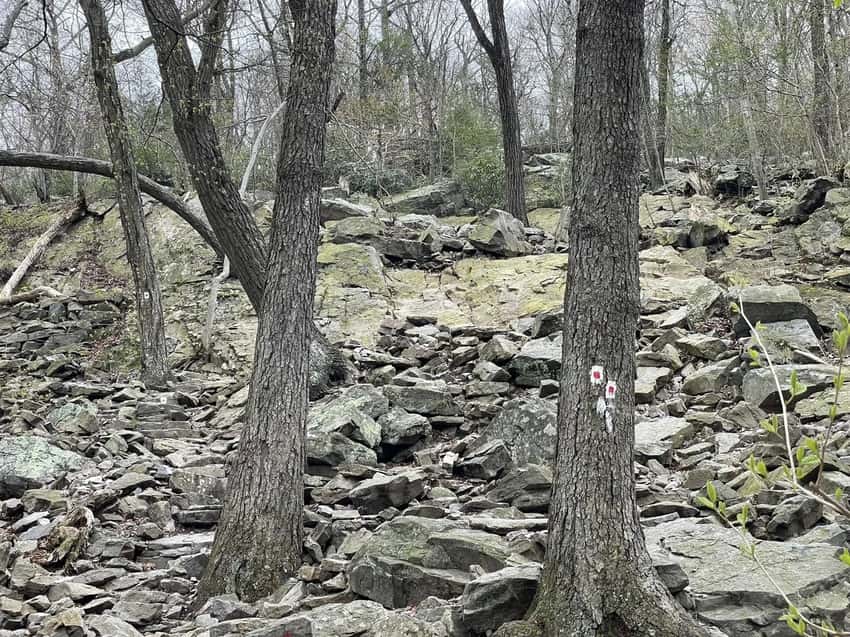
Mt. Tammany Red Dot Trail - steep, rocky, and strenuous
The River (Tubing and Kayaking)
The massive Delaware River is the main attraction for non-hikers. Outfitters like Edge of the Woods and Chamberlain Canoes offer tube and kayak rentals with shuttle service.
- Cost: Expect to pay $40-60 per person.
- Safety: The river is wide and generally calm, but currents can be strong. Always wear a life jacket.
Fees (It’s Not Free)
There is no entrance fee to drive through the park (it’s a public highway, after all), but extensive “Expanded Amenity Fees” apply at:
- Milford Beach (PA)
- Smithfield Beach (PA)
- Turtle Beach (NJ)
- Dingmans Access (Boat Launch)
Cost: Currently $10 per vehicle, but a proposed increase to $20 per vehicle is expected in April 2025.
What You Need to Know Before You Go
I-80 Is a Nightmare
The interstate cuts right through the Gap. On Friday afternoons (westbound) and Sunday afternoons (eastbound), it is bumper-to-bumper traffic. Plan for delays.
Cell Service Is Spotty
Coverage is inconsistent in the gorge and on the river. Download your maps offline.
Photography Tips
Best Mt. Tammany Shot: Sunrise from the summit (6:00-7:00 AM) in fall (September 25-October 15) when the surrounding ridges are colorful and mist rises from the river below. Wide-angle lens (16-35mm) captures the full ridge-and-river vista.
Best Raymondskill Falls Shot: Spring (April-May) for peak water volume. Shoot from the base observation area with a telephoto lens (70-200mm) to isolate individual tiers. Use 1-2 second shutter speed for silky water effect.
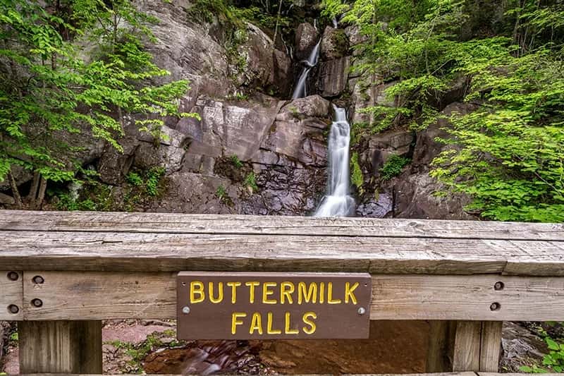
Buttermilk Falls (NJ side)
Located just across the river from the Pennsylvania side, Buttermilk Falls is one of the highest waterfalls in New Jersey, cascading roughly 200 feet down the Kittatinny Ridge. Unlike Raymondskill, this is a “roadside” waterfall with almost zero approach hike, making it a perfect quick stop.
- Access: Located on Mountain Road (NJ side). Be aware that the road is dirt and can be rough/pitted after heavy rains.
- The Experience: A well-maintained wooden staircase climbs the side of the falls, providing multiple observation decks to view the different tiers.
- Hiking Connection: The top of the stairs connects to the Buttermilk Falls Trail, a strenuous 1.4-mile climb that meets the Appalachian Trail at the ridge top.
- Insider Tip: Visit in early spring or immediately after a heavy rain for the most dramatic flow. In late summer, the falls can dwindle to a trickle.
Buttermilk Falls (NJ) - New Jersey’s tallest waterfall
Best River Shot: Late afternoon (4-6 PM) from the overlooks. The golden hour light strikes the Delaware River and highlights the Gap’s geology. The river is widest and most photogenic from Mt. Tammany’s summit or the scenic overlooks along Route 209.
Insider Tips
Mt. Tammany Parking Strategy: Arrive by 7:30 AM on weekends or go on weekday mornings. If you must go Saturday afternoon, accept you’ll park at the Kittatinny Visitor Center and walk 10-15 minutes. Never risk the I-80 shoulder overflow parking, it’s illegal and dangerous.
Red Dot Scramble Reality: Hands-on scrambling is real. Wear proper hiking boots with ankle support. If you’re uncomfortable with exposure or scrambling, take the Blue Dot trail both ways (easier but longer).
Raymondskill Falls Winter: The falls partially freeze in winter, creating dramatic icicle formations. January-February offers unique photography, but the approach is treacherous. Bring traction aids.
Dingmans Falls Closure: Don’t bother driving to Dingmans Falls, it’s closed until Spring 2026. The access road is gated. Use that time to explore Hornbecks Creek instead (unmarked but less crowded waterfalls).
I-80 Traffic Reality: Avoid I-80 on Friday afternoons westbound (heading to the Gap) and Sunday afternoons eastbound (leaving). The interstate can have 30+ minute delays. Weekday mornings are almost always clear.
River Outfitter Booking: Tube and kayak outfitters get extremely busy on summer weekends. Book ahead or arrive by 8 AM for same-day availability. Expect crowds on the water between 10 AM-3 PM.
Cell Service Reality: Coverage is spotty in the Gap and nonexistent on many trails. Download offline maps before arriving. Tell someone where you’re going.
Mt. Minsi Alternative: If Mt. Tammany is too crowded or you want an easier hike with a similar view, hike Mt.
Minsi from Kittatinny Point (PA side). It’s on the Appalachian Trail, slightly less steep, and often quieter.
Best Time to Visit
- Spring (April-May): Raymondskill Falls at peak flow. Wildflowers bloom. Lighter crowds than summer. Dingmans Falls still closed
- Summer (June-August): Peak season for river tubing and swimming. Mt. Tammany is packed. Early morning (before 8 AM) is essential
- Fall (September 25-October 15): Peak foliage is spectacular. Mt. Tammany will be busy. Cooler hiking temps. Best photography season
- Winter (December-March): Quiet and peaceful. Raymondskill Falls partially freezes. Icy trails require traction aids
FAQ
Is Dingmans Falls open? No. It is closed until Spring 2026.
Can you swim in the waterfalls? No. Swimming is prohibited at Raymondskill and all waterfalls. Swim at the designated beaches on the river (Smithfield/Milford).
Is it free? Driving through is free. Parking at beaches costs money.
Which side is better, PA or NJ?
- NJ Side: Has Mt. Tammany (the harder hike, iconic view).
- PA Side: Has Mt. Minsi (Appalachian Trail, easier hike), Raymondskill Falls, and the river beaches.
Explore More
Nearby Waterfall & Gorge Hiking:
- Raymondskill Falls Trail (15 minutes): Pennsylvania’s tallest waterfall. Pair with Mt. Tammany for an all-day Gap adventure
- Hickory Run State Park (45 minutes): Boulder Field geological wonder and Hawk Falls. Similar Poconos terrain with less I-80 congestion
- Bushkill Falls (10 minutes): Eight separate waterfalls on a developed trail. Less crowded alternative if Raymondskill is busy
Nearby Hiking Alternatives:
- Mount Minsi (15 minutes): Appalachian Trail section with similar Tammany-facing views. Slightly easier, often quieter
- Promised Land State Park (60 minutes): Three flat lake-walking trails if you want to escape mountain climbing
Regional Guides:
- Full Poconos region guide for comprehensive waterfall and hiking cluster
- Lehigh Valley region guide for nearby Hawk Mountain and Valley Forge history
Similar Experiences:
- Palisades Interstate Park, NY: 30 minutes away, similar river gorge geology with Hudson River instead of Delaware
- Catskill Mountains, NY: 90 minutes away, larger wilderness alternative with more serious backpacking
- Shawangunk Ridge, NY: 60 minutes away, rock scrambling and ridge views comparable to Mt. Tammany