Mount Tammany Loop: The Parking Lottery (And How to Win It)
Red Dot scramble, Blue Blaze descent, and the real parking situation at one of the best views in NJ/PA. Everything you need before you go.
Key Takeaways
- Navigation: Park at the Dunnfield Creek lot (Google Maps | Apple Maps). GPS: 40.9723, -75.1259. Arrive before 8:30 AM to secure a spot.
- Route Choice: Hike UP the Red Dot scramble and DOWN the Blue Blaze trail for maximum knee safety.
- Technical Scramble: Expect hands-on climbing with 1,200 ft of gain, bring boots with solid ankle support.
- Safety Alert: Watch for Timber Rattlesnakes basking on sunny ridgetop outcrops from May to September.
Parking, This Determines Your Whole Day
Dunnfield Creek Lot (The Main Lot)
The trailhead parking is at the Dunnfield Creek lot, accessed from I-80 westbound via the Dunnfield Creek/Appalachian Trail exit. It fills by 8:30 AM on weekends during warm weather and peak fall foliage. On October peak weekends it can fill by 8:00 AM.
Arrive before 8 AM or plan to miss it. After 3 PM is also a realistic window if you are comfortable with the sunset timing relative to your planned summit time.
Overflow: Kittatinny Point Visitor Center
When the Dunnfield Creek lot is full, the Kittatinny Point Visitor Center lot under I-80 is the overflow option. It is a 15-minute walk to the Dunnfield Creek trailhead. The Visitor Center itself may be closed due to NPS staffing, but the parking lot remains accessible.
Do not park on the I-80 shoulder or roadside grass. State Troopers patrol this actively on weekends and the fine ($55 or more) plus towing costs ($75 or more plus impound) add up fast. People get towed here every busy weekend.
Shuttle Option
The Water Gap Hiker Shuttle runs seasonally on select holiday weekends. Check gomcta.com for current schedules before planning around it, availability changes year to year.
This is what 8:45 AM looks like at Dunnfield Creek on an October Saturday.
The Route: Up Red Dot, Down Blue Blaze
Why This Direction
The Red Dot Trail is steep. Climbing steep is harder on your cardiovascular system. Descending steep is harder on your knees and significantly more dangerous on loose, rocky scramble terrain when your legs are already fatigued. You go up Red Dot because doing it the other direction means descending the rock scramble on tired legs, which is how people get hurt on this trail.
Do not go down the Red Dot.
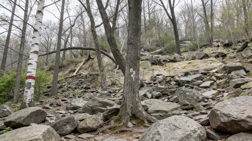
Red Dot Trail, The Ascent (1.2 Miles to Summit)
The Red Dot Trail starts at the Dunnfield Creek parking area and climbs 1,200 feet in approximately 1.5 miles. The grade is sustained and the terrain transitions from wooded trail to rock scramble within the first half mile. The scramble sections require three points of contact, two hands and one foot, or two feet and one hand, on the exposed rock faces.
This is not technical climbing. No ropes or specialized gear are needed. It is, however, genuinely strenuous and requires the use of your hands on the steeper sections. If you have not done a scramble before, the move is to take it slow, test holds before weighting them, and not rush people behind you.
Views open up during the climb. Unlike many hikes where the view is reserved entirely for the summit, the Red Dot gives you partial views as you gain height, a useful visual reward that helps with pacing.
The Red Dot scramble. Hands required. Take it one section at a time.
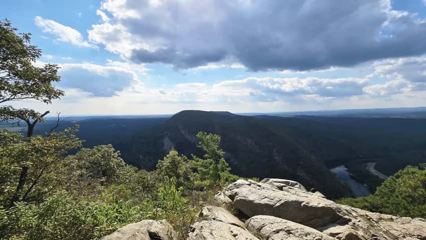
The Summit
The summit area is an open rocky ridge with 180-degree views south. The Delaware River curves through the gap below. Mount Minsi rises on the Pennsylvania side across the water.
I-80 runs through the valley floor, small from this elevation. On clear days the view extends well south down the river valley.
The summit gets crowded on weekends. There is room to spread out on the rock slabs but popular ledge-edge positions fill up. Give yourself time here, the view earns it.
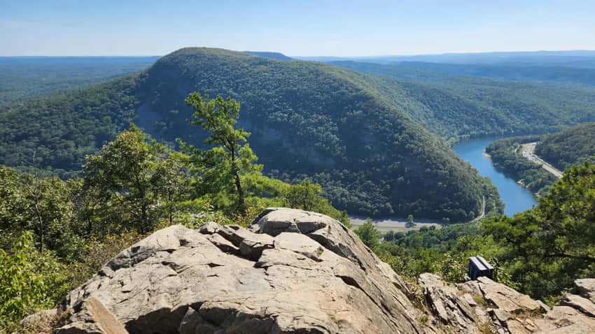
The summit view south over the Delaware River. Mount Minsi rises on the PA side.
Blue Blaze Trail (Pahaquarry Trail), The Descent (2 Miles)
The Blue Blaze descent runs approximately two miles back to the trailhead. It is a dirt path, wider, shadier, and significantly less rocky than the Red Dot, that winds down the back side of the ridge before returning to Dunnfield Creek. The grade is steady but manageable.
Near the bottom, small pools in Dunnfield Creek are accessible from the trail and are a common stop for cooling off after the descent. The creek is cold and clear. These are not designated swimming areas, but wading in the creek is standard practice on warm days.
What the Scramble Is Actually Like
Hands and Feet
The scramble sections on the Red Dot require you to use your hands to pull up and stabilize on exposed rock faces. There are roughly three distinct scramble sections below the final ridge approach.
The rest of the trail is steep but not a hands-on scramble. Most hikers in reasonable shape find the scramble achievable if they take it slowly. The bottleneck on crowded weekends is often pace mismatches between strong hikers and slower groups in the scramble sections, be patient when passing options are limited.
Wet Conditions
The Red Dot rock faces are significantly more dangerous when wet. Rain-slicked quartzite offers substantially less friction than the same rock dry. If there has been rain in the 12 hours before your hike, consider whether you want to commit to the scramble. The consequence of a slip on the steeper sections is serious.
Dogs on the Red Dot
The scramble is manageable for athletic, medium-to-large dogs who are comfortable on uneven terrain. Small dogs and older dogs may need assistance on the larger rock transitions. If your dog struggles with stairs at home, the Red Dot is not the right trail. The Blue Blaze is a significantly better choice for dogs on both sections.
Safety
Snakes. Copperheads and Timber Rattlesnakes are present on the rocky outcrops along the Red Dot ascent and especially at the summit. The warm, sun-exposed quartzite is prime basking habitat from May through September. Watch where you place your hands during the scramble, do not reach blindly onto a ledge above you.
Watch your step at the summit. If you encounter a snake, give it space and wait for it to move.
Ticks. The wooded lower sections of both trails have tick activity from April through October. The Blue Blaze descent passes through brushy creek-side vegetation where tick density is higher. Do a full check after the hike.
Winter. The Red Dot scramble on ice is a different category of hazard. Microspikes are the minimum requirement for any winter visit where temperatures have been below freezing. The rock faces hold ice long after the temperature rises above freezing. Not recommended without winter-specific footwear when conditions are uncertain.
Crowds. The trail is genuinely crowded on weekends. Locals call it the Times Square of hiking. Weekdays are consistently quieter. Sunrise hikes clear the parking problem and the crowd problem simultaneously.
Best Times to Hike
Spring (April through May): Cooler temperatures, fewer crowds than fall peak, and the deciduous forest is fully leafed in by mid-May. Waterfall flow in Dunnfield Creek is highest. Better hiking conditions than summer on the scramble.
Summer (June through August): Hot on the exposed scramble sections. The forest on the Blue Blaze descent and the creek pools at the bottom compensate. Crowds are heavy on weekends. Sunrise or late afternoon are the practical alternatives to midday heat.
Fall (September through October): Peak foliage around the second week of October is spectacular from the summit, the river and the gap below are surrounded by color. This is also the most crowded period. Arrive by 7:30 AM on peak October weekends or plan for the overflow lot. Ticks remain active into early October.
Winter: Ice on the scramble makes this genuinely dangerous without microspikes. Off-peak winter weekdays with dry and cold conditions (no recent rain or freeze-thaw cycle) produce excellent visibility from the summit and no crowds at all.
What to Bring
- Water, at least 1.5 liters per person. 1,200 feet of gain burns water faster than flat trail.
- Hiking boots with ankle support, the scramble sections and the root-covered descent both benefit from ankle stability
- Gloves (optional), useful for protecting hands on the rock scramble in cold weather
- Tick kit, tweezers or tick hook. Check after the Blue Blaze descent through the creek corridor
- Microspikes, any winter visit where ice is possible on the scramble
- Snacks, the summit is worth a proper break. Bring enough food to sit for 20 minutes
FAQ
When should I arrive for parking? Before 8 AM on weekends. After 3 PM is an option if sunset timing gives you enough daylight. Do not count on finding a spot between 8:30 AM and 3 PM on a warm or peak foliage weekend.
Which direction should I hike? Up Red Dot, down Blue Blaze. Going down the Red Dot scramble on tired legs is where injuries happen.
How hard is the Red Dot scramble? Steep and rocky with sections requiring hand use. Not technical climbing, but a step above a standard hiking trail. If you have never done a scramble before, take each section slowly and do not rush.
Are there snakes? Yes, Copperheads and Timber Rattlesnakes on the rocky outcrops. Watch where you put your hands on the scramble and look before stepping at the summit.
Can I bring my dog? Yes, on a 6-foot leash. The Red Dot is challenging for small or older dogs. The Blue Blaze descent is more manageable. Know your dog’s comfort level on uneven terrain.
Is there a shuttle? The Water Gap Hiker Shuttle runs on select holiday weekends. Check gomcta.com for current schedules.
The Mount Tammany summit view is worth the drive from anywhere in the Poconos or Lehigh Valley region. If you are building a weekend around the Delaware Water Gap, the Delaware Water Gap National Recreation Area guide covers the full range of trails, river access, and camping options in the park.
The Falls Trail at Ricketts Glen is the other bucket-list Pennsylvania hike worth pairing on the same trip if you are driving in from New York or Philadelphia.