Hyner View State Park: Overlook, Directions & Visit Guide
A six-acre state park built around one thing: a long view over the West Branch Susquehanna. Here's how to reach it, what's there, and what to check first.
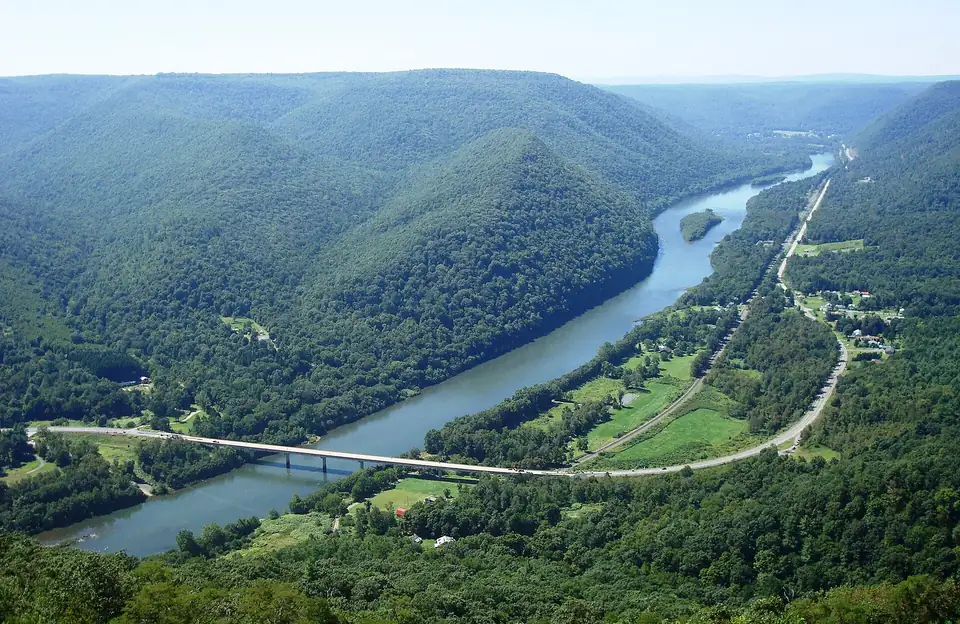
Photo: Beyond My Ken / Wikimedia Commons, CC BY-SA 4.0, resized. A temporary photo until we add our own.

Hyner View is a good choice if you want a big view without a long hike: the official directions take you by road to the overlook. The trade-off is that there isn’t much else here. The park covers six acres, so treat it as a stop on a longer day in the area, not a destination on its own.
This guide is based on the Pennsylvania DCNR park page, checked November 5, 2026. Conditions change, so check with the park before you go.
What you’ll find
The main attraction is the overlook, with long views upstream and downstream along the West Branch of the Susquehanna River and over the surrounding mountains.
DCNR lists three activities:
- Picnicking: Bring what you need, since DCNR lists no reservable facilities.
- Hang gliding: DCNR calls the park a favorite spot for it. That doesn’t mean you’ll see flights on a given day, so don’t plan a long trip around them.
- Accessible recreation: The park has an accessibility listing on the DCNR site. Check it or call the office if you have specific needs.
The park has no reservable facilities. Hunting is prohibited inside the park, though nearby Sproul State Forest is open to hunting and trapping, so keep the season in mind if you walk beyond the park.
How to get there
Use the route that matches your direction. All three come from DCNR.
From PA 120 at the village of Hyner:
- Turn east onto Hyner Run Road (PA 1014) and go about 2 miles.
- Turn right onto Hyner View Road and drive about 5 miles to the view.
From PA 44:
- Turn west onto Hyner Mountain Road and go 5.2 miles.
- Just past the Hyner Run State Park entrance, turn left onto Hyner View Road.
- Drive about 5 miles to the view.
Alternate route from PA 44 (unpaved state forest roads):
- Go west on Hyner Mountain Road for 1 mile.
- Turn left onto Ritchie Road and go about 2 miles.
- Turn right onto Old View Road and go about 3 miles.
For navigation: the street address is Hyner View Road, Hyner, PA 17738, and the GPS coordinates are 41.32675, -77.62375.
Hours and what to check first
The park is open every day from sunrise to sunset, and day use areas close at dusk.
DCNR’s page doesn’t cover the points below, so call the office at 570-923-6000 or email littlepinesp@pa.gov if they affect your plans:
- Winter road conditions: Ask before driving up in snow or ice, especially on the unpaved route.
- Restrooms and other facilities: Facility seasons and hours are handled through the Hyner Run State Park office.
- Hang gliding rules: If you plan to fly, ask about current requirements.
Hang gliding at Hyner View
According to DCNR’s hang gliding page, pilots launch from the ramp at the scenic vista and glide out over the West Branch of the Susquehanna River. You need DCNR authorization before you fly, so contact the park office about the process.
Third-party sources say the Hyner Hang Gliding Club is the authorized club at the park, and that its fly-ins are usually on Memorial Day and Labor Day weekends, weather permitting. DCNR’s page doesn’t confirm either point, so check before planning a trip around one. The same club material describes the landing zone as a small field near the park entrance, bordered by trees and power lines, and recommends the site for experienced pilots.
If you’re there to watch, flights depend on wind and weather, so any given day may have none.
Can you hike to the overlook?
Possibly, but we haven’t verified a route. One third-party guide, MyHikes, describes a climb that reaches the overlook at about mile 1.45, and other listings give different lengths. DCNR’s park page doesn’t list any trails.
DCNR does say the Donut Hole Trail passes through Hyner View State Park. It is a 90-mile, orange-blazed point-to-point trail, rated most difficult, that also crosses Kettle Creek and Hyner Run state parks and connects with the Susquehannock Trail System.
Before hiking it, confirm the route on a current state forest map. Carry that map, and do not rely on phone signal for navigation.
Safety and nearby help
- Emergencies: Call 911, then contact a park employee.
- Mental health or substance use crisis: Call or text 988.
- Nearest hospital: Bucktail Medical Center, 1001 Pine Street, South Renovo, PA 17764, 570-923-1000.
Build a longer day
Hyner Run State Park is close by, and you pass its entrance on the PA 44 route. DCNR describes it as a 180-acre park surrounded by Sproul State Forest, the state’s largest. Its listed activities include fishing, hiking, picnicking, swimming, overnight stays and winter recreation. The pool and overnight areas are seasonal, so check with the park office.
For a longer hike from Hyner Run, DCNR lists the Long Fork Trail, a 4.1-mile loop rated most difficult, with a steep climb and descent, a stream along part of the route and a short side trail to an overlook. Potable water and picnic tables are at its trailhead.
For more hikes in this part of the state, see our Central PA hiking guide.