Laurel Highlands Hiking Guide: LHHT, Ohiopyle & Mountain Trails
From the 70-mile LHHT to Ohiopyle's waterfalls and the highest point in PA, the Laurel Highlands is where Pennsylvania gets rugged. Complete guide to trails, camping, and planning your adventure.
Key Takeaways
- LHHT Beginner Strategy: The first 6.5 miles of the Laurel Highlands Hiking Trail out of Ohiopyle are the most brutal (1,000+ feet of gain). Beginners should start at Route 653 or Route 31 for flatter, ridge-top sections that offer better views for less effort.
- Mount Davis Observation: Don’t just stand on the state’s highest point marker. It has zero view. Climb the nearby observation tower for a 360-degree panorama into West Virginia and Maryland.
- Ohiopyle Parking Secret: The main lots fill by 10:00 AM. Park at the Dinnerbell Road overflow lot; it adds a 10-minute walk but saves an hour of circling for a spot.
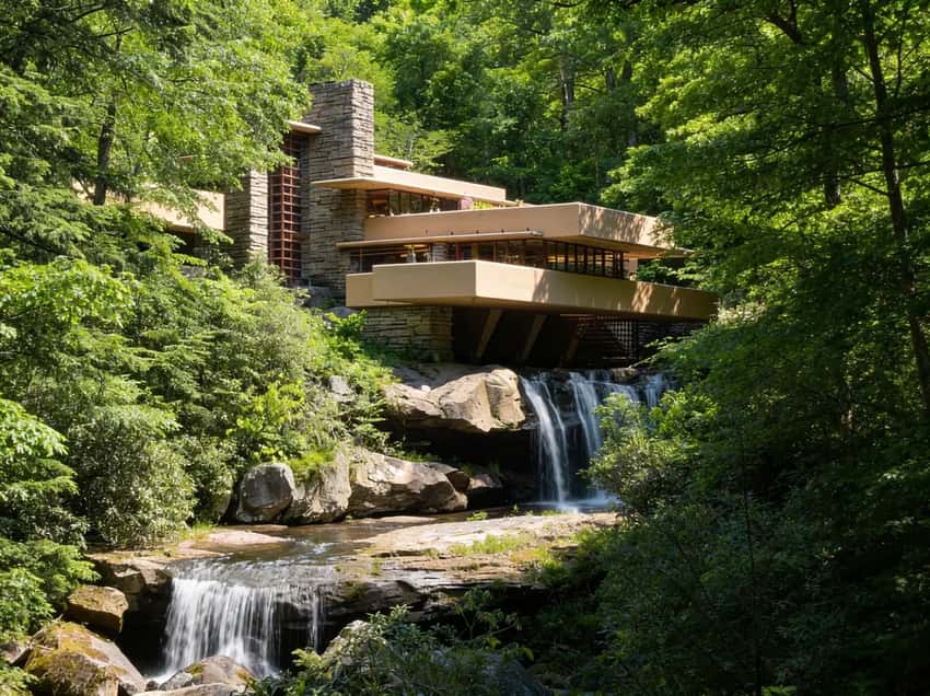
- Fallingwater Ground Pass: If tours are sold out, check for a “Grounds-Only Pass” on the official website. It allows you to hike the estate and see the exterior of the house without a 6-month reservation.
- Quebec Run for Solitude: If the Ohiopyle crowds are overwhelming, head 20 minutes south to Quebec Run Wild Area. It offers the same rugged terrain with zero amenities and perfect solitude.
If you’ve hiked enough of Pennsylvania to know the difference between mountains and tall hills, the Laurel Highlands are where you finally get the real deal. This is the state’s highest ground, defined by the 1,000-foot-deep Youghiogheny River Gorge and the 70-mile spine of the Laurel Highlands Hiking Trail (LHHT).
Why Hike the Laurel Highlands?
This is the Allegheny Plateau, the highest elevation in Pennsylvania. Unlike the rolling landscape of the Southeast, this is mountain country. It’s steep, it’s green, and it feels significantly wilder than the rest of the state.
The region is anchored by Ohiopyle State Park, the adventure capital of the Mid-Atlantic, but the real soul of the Highlands is found on the LHHT. It is the only long-distance trail in the state with a dedicated shelter system, making it the premier destination for multi-day wilderness backpacking.
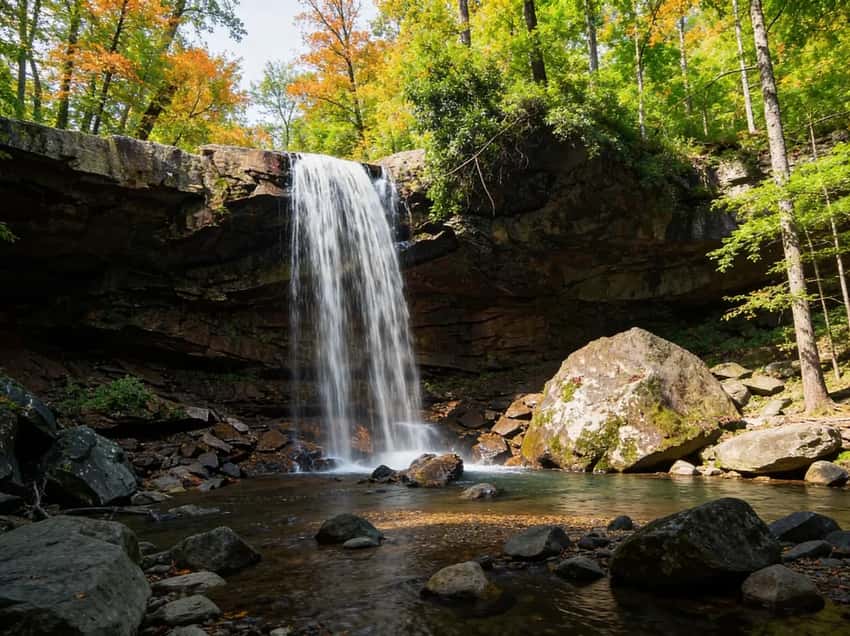
If You Want Waterfalls: Ohiopyle State Park
Ohiopyle is the center of the action. It’s also the busiest. The park offers over 79 miles of trails, but these are the waterfall highlights:
Cucumber Falls Trail (0.5 miles, easy)
A 30-foot drop that you can walk behind. The most accessible waterfall in the park.
- Distance: 0.5 miles round trip
- Elevation: Minimal (100 ft descent)
- Time: 20-30 minutes
- Difficulty: Easy (paved path to overlook, stairs to base)
- Best Time: Spring for high flow, fall for fewer crowds
- Parking: Cucumber Falls parking area off Dinnerbell Road
What to Expect
This is the gateway waterfall for Laurel Highlands hiking. It is short enough for families and spectacular enough to feel like a real waterfall experience. The paved section gets you to an overlook with full spray and sound. Then stairs descend to the base where you can walk behind the curtain of water.
The spray creates a perpetual mist. Bring a microfiber cloth for your camera lens. For footwear, sneakers work on the paved section.
But if you want to go behind the falls, wear water shoes or boots with good grip. The moss-covered rocks under the spray are slippery.
Spring delivers the most dramatic flow, but crowds are heavy on weekends. Fall offers solitude and softer light for photography. Winter transforms the upper rocks into ice formations. This looks dramatic in photos but makes the descent dangerous without crampons.
The parking lot fills by 10 AM on sunny weekends. Arrive before 9 AM or come on a weekday.
Meadow Run Trail (3.5 miles, moderate)
Natural waterslides carved into sandstone. It’s fun, but the rocks are slick and head injuries happen. The trail follows Meadow Run through a series of cascades and slides.
- Distance: 3.5 miles (can be shortened)
- Elevation: 400 ft descent
- Time: 2-3 hours
- Difficulty: Moderate (rocky, stream crossings)
- Best Time: Summer for sliding (water levels permitting)
- Pro Tip: Bring water shoes with good grip. The rocks are extremely slippery.
What to Expect
Meadow Run is the slide hike. You’ll find natural waterslides polished smooth by millennia of flow. But here’s the reality. Those polished rocks are slippery.
People slip and head injuries happen. This trail demands respect and proper footwear.
Water shoes or sticky-soled climbing shoes are not optional. They are the difference between a confident descent and one bad step. The 3.5-mile route follows the stream almost the entire way with multiple cascade sections.
You’ll do actual stream crossings. Expect to be shin to knee-deep depending on water level. You will also scramble over boulders and navigate sections where the trail basically IS the creekbed.
Summer is the official slide season when water levels drop. But that is also peak tourism season at Ohiopyle. Spring brings higher water. Fall offers solitude but lower water.
Start early to avoid crowds and secure parking at the Meadow Run trailhead. Bring trekking poles. They provide essential balance on slick sandstone.
Plan 2-3 hours for the full loop. You can shorten this to just the lower cascade section if you want less commitment.
Jonathan Run Falls Trail (3.2 miles, moderate)
The quiet alternative. You’ll see fewer people and more waterfalls - including Jonathan Run Falls and several smaller cascades.
- Distance: 3.2 miles loop
- Elevation: 600 ft descent
- Time: 2-3 hours
- Difficulty: Moderate (steep sections, stream crossings)
- Highlights: Multiple waterfalls, old-growth hemlock forest
- Best Time: Spring for waterfall flow, fall for solitude
What to Expect
Jonathan Run is the antidote to crowded Ohiopyle. While Meadow Run and Cucumber Falls draw tour buses, this trail stays quiet. This is partly because it’s less famous and partly because it’s legitimately steep.
The payoff is multiple waterfalls in quick succession and old-growth hemlock forest. Some trees are over 300 years old. You get the sense that you’ve discovered something the casual visitor misses.
The loop climbs steeply at the start. Then it descends through the waterfall section where you’ll cross the stream multiple times. Stream crossings vary by season.
Spring snowmelt makes them thigh-deep and fast. Summer and fall are closer to shin-deep.
Good hiking boots with ankle support matter here. You need stability on loose rock and rooty sections. Spring delivers thundering waterfalls and wildflower blooms. Fall offers crisp air and stable footing.
The parking area is small. Arrive early or plan a weekday visit. This is Laurel Highlands hiking without the tourism infrastructure. That’s exactly the appeal.
⚠️ Warning: Swimming near Ohiopyle Falls is prohibited. The Youghiogheny River is a powerful Class III-IV whitewater river - people die here every year. Respect the current.
If You Want Views: Baughman Rock & Wolf Rocks
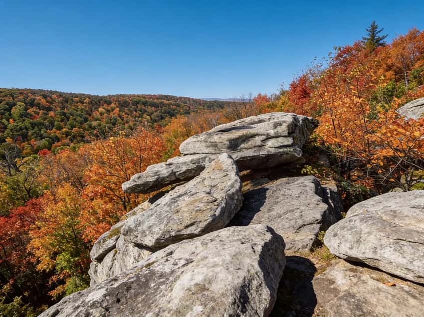
For one of the best views of the Youghiogheny Gorge, head to Baughman Rock. It’s a steep climb if you hike it, but you can drive most of the way to the overlook. Go at sunset. You can also explore nearby Wolf Rocks, known for its sheer sandstone cliffs and panoramic vistas.
What to Expect
Baughman Rock delivers the Laurel Highlands hiking experience in an efficient package. It offers minimal effort for maximum payoff. You can drive directly to the overlook area. This means no 2-hour approach hike before you see the view.
The drive itself is scenic with narrow mountain roads. Short walking trails lead to cliff-edge overlooks that drop straight into the Youghiogheny Gorge.
The light here is magic in the late afternoon. The gorge walls glow golden in fall and shadows create depth in winter. Sunset photography is the main draw. Arrive 45 minutes before sunset and you’ll have time to scout compositions.
Wolf Rocks is nearby. It adds scrambling and more dramatic sandstone formations if you want additional exploration. The hike is easy to moderate and suitable for most fitness levels.
Fall is peak for gorge foliage color. Spring offers wildflowers and clearer air. Summer crowds are moderate. Winter transforms the overlooks into frost-covered vistas.
They are stunning but icy. Bring microspikes if you’re doing Wolf Rocks scrambling in frozen conditions.
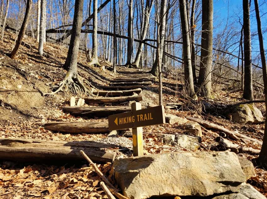
If You Want Backpacking: Laurel Highlands Hiking Trail (LHHT)
This is the big one. 70 miles of ridge-walking with 8 shelter areas spaced every 6-12 miles. This is Pennsylvania’s premier long-distance backpacking trail.
- Distance: 70 miles point-to-point (Ohiopyle to Seward)
- Elevation: ~14,000 ft cumulative gain
- Time: 5-7 days for thru-hike
- Difficulty: Strenuous (sustained elevation changes, rocky terrain)
- Trailheads: South: Ohiopyle State Park, North: Seward (near Johnstown)
- Shelters: 8 Adirondack-style shelters with bunks, picnic tables, and privies
- Water: Streams throughout (filter required), some shelters have nearby springs
- Reservations: Required for all shelters. Call 724-455-3744 or visit PA State Parks Reservations. Cost: $5-10 per person per night.
- Best Season: Fall (late September to mid-October for foliage)
What to Expect
The LHHT is the backpacking spine of the Laurel Highlands. It offers 70 miles of ridge-walking with dedicated shelter infrastructure. This means you don’t have to seek out your own campsites.
Each shelter sleeps 8 to 12 in bunk beds. It also has a picnic table and a privy. Water is usually within hiking distance. You will still need to filter everything.
The terrain is relentlessly hilly. You are climbing 14,000 cumulative feet over 70 miles. Even though the individual elevation gains aren’t huge, your legs will notice the sustained effort.
Sharp sandstone and shale rocks are underfoot. Quality boots matter because blisters will end a backpacking trip.
Weather can turn fast in the fall. Mornings are crisp and afternoons are pleasant. But rain can come suddenly, especially in late September.
The first 6 miles out of Ohiopyle are brutal. You climb 1,000 feet straight out of the river gorge. It is exposed, rocky, and relentless. Experienced backpackers handle it, but newcomers often struggle.
If you are testing gear or fitness, start at Grindle Ridge Shelter instead. The section from there northward is more forgiving.
The most popular section is Ohiopyle to Laurel Ridge State Park. This 30-mile stretch is doable in 3-4 days. It has the best views and most reliable water.
Fall foliage peaks in early October. Shelter reservations fill months in advance for those weekends. Book in June if you want a fall trip.
Spring offers wildflowers but the trails are muddy. Summer is hot, humid, and buggy.
You must stay in shelters. Dispersed camping is not allowed on the LHHT. Arrive 30 minutes before sunset. Many hikers will be at each shelter on popular weekends and bunks fill fast.
If You Want the Highest Point: Mount Davis
Yes, it’s 3,213 feet, but don’t expect a jagged peak. It’s a high plateau covered in forest. You can drive to the top and climb an observation tower to get above the trees.
- Elevation: 3,213 ft (highest point in Pennsylvania)
- Location: Forbes State Forest, near Salisbury
- Access: Drive to the summit via Mount Davis Road
- Tower: 40-foot observation tower for views above the treeline
- Trails: Short nature trails around the summit area
- Best Time: Fall for foliage, winter for snow-covered views
- Pro Tip: It’s geologically significant even if it’s not a dramatic climb. The tower offers 360-degree views on clear days.
What to Expect
Mount Davis is Pennsylvania’s highest point. But the experience is more like visiting a high place than climbing a dramatic peak. There’s no jagged summit.
It’s a forested plateau. The trees block the view until you climb the 40-foot observation tower.
That tower is the payoff. On a clear day, you get 360-degree vistas of the Appalachian plateau spreading in all directions. The drive to the summit is scenic. You can reach the tower in 30 minutes total.
Short nature trails loop around the summit area. They are suitable for families. The tower itself requires climbing stairs. It’s accessible but not for people with mobility restrictions.
Fall is peak for foliage color across the plateau. Winter sometimes brings snow.
This is the “checksum” hike. It is quick, achievable, and genuinely interesting geologically.
If You Want Solitude: Quebec Run Wild Area
If Ohiopyle is a zoo, Quebec Run is a library. It’s 10/10 for solitude with zero amenities. You can camp (dispersed) here, but check DCNR rules first.
This 2-mile loop at Ohiopyle is a botanical wonder. Rare plants from Maryland and West Virginia wash down the Yough (since it flows north) and take root here, creating a unique microclimate.
What to Expect
Ferncliff is the botanical outlier of Laurel Highlands hiking. It’s a 2-mile loop that packs more plant diversity than trails twice its length. The Youghiogheny River flows north, which is unusual for Pennsylvania rivers.
Seeds and spores from southern Appalachian species in Maryland and West Virginia wash downriver and establish here. This creates a pocket of southern flora in southwest PA. You’ll see plants normally found 100 miles south flourishing on this peninsula.
The trail is easy walking. Interpretive signage explains the ecology. Late April and May bring trilliums and Virginia bluebells.
June offers mountain laurel and rhododendron. Late July and August bring blazing star and black-eyed Susan.
The peninsula juts into the river. You’re hiking through a narrow corridor with water visible most of the route. This makes it cooler than surrounding areas.
Dress warmly even on warm days. The water-adjacent microclimate stays cool.
The main Ohiopyle lot fills by 10 AM on summer weekends. Arrive early or visit on a weekday. This is for the botanically curious or photography enthusiasts rather than peak-baggers.
Insider Tips: How to Hike the Laurel Highlands Like a Local
Parking Strategy for Laurel Highlands Hiking
The golden rule: arrive before 8:30 AM on weekends, or plan a weekday visit. Ohiopyle’s main parking lots fill by 10 AM on sunny days. Here’s the breakdown by location:
- Ohiopyle (Cucumber Falls, Meadow Run, Jonathan Run, Ferncliff): The main lot holds roughly 80 spaces. An overflow lot adds another 40. By 10 AM on summer Saturdays, both are full. Secondary parking lots like Waltz Mill and Dinnerbell Road add more capacity but are less known. Use these if the main lot is full.
- LHHT trailheads: Ohiopyle South Trailhead is packed for fall foliage weekends. The Seward trailhead near Johnstown offers parking but is 2 hours from Pittsburgh. Consider section hikes that start at mid-trail shelters if Ohiopyle looks impossible.
- Mount Davis: Small lot at the summit, rarely full. Drive right to the tower.
- Baughman Rock/Wolf Rocks: Minimal parking. Smaller lots mean less crowding than Ohiopyle.
- Quebec Run: Pull-off parking with 5 to 10 spaces. It is rarely full because it is not publicized.
Pro move: If Ohiopyle looks full on your arrival, park at Dinnerbell Road (overflow area), walk across the road bridge, and pick any trail from there. It adds 10 minutes but beats circling the lot.
Seasonal Reality for Laurel Highlands Hiking
-
Spring (April to May): Waterfalls are raging with snowmelt. You’ll see peak water flow at Cucumber, Meadow Run, and Jonathan Run. Wildflowers explode. But mud is substantial, especially on the LHHT. Stream crossings are thigh-deep and fast. Bug season begins with ticks emerging mid-April. Stick to shorter trails unless you are comfortable with water and mud.
-
Summer (June to August): Warmth, greenery, and water-based activities like swimming at Meadow Run slides. Crowds peak during this time. Parking fills early. Heat and humidity are intense in the gorge.
The natural water slides require you to line up behind other hikers. Bring 3 or more liters of water. Start early to avoid the afternoon heat. Ticks are active and hungry.
- Fall (September to October): Peak season. Foliage on the LHHT is spectacular. This typically happens between October 5 and 15. Crowds are heavy because everyone knows about fall color. Shelter reservations for the LHHT fill months in advance.
Weather swings wildly. September can be 80°F and humid while October mornings drop to 40°F. Rain can come suddenly. Pack layers and rain gear.
This is the season to hike. Accept the crowds or plan a weekday visit.
- Winter (November to February): Solitude is excellent. Fewer crowds at Ohiopyle. LHHT shelters stay open for serious backpackers.
Wet rocks become icy. Waterfalls freeze into icicles. This is photogenic but treacherous. Parking lots are empty because conditions are brutal.
Solo winter hiking is for experienced mountaineers. Day hikes on Baughman Rock or Cucumber Falls work in winter. Bring microspikes for icy descents.
Snake Awareness in Laurel Highlands Hiking
Copperheads and Timber Rattlesnakes are present. Look for them on rocky ridges and on warm days from May through September. You likely won’t see one. But you need to know the protocol.
Stay on the trail. Snakes avoid people. Off-trail scrambling increases encounters.
Watch hand and foot placement. Don’t reach into crevices or under logs without looking.
On the LHHT, watch where you place your hands when scrambling. Listen for a dry, buzzing sound like maracas. If you hear it, back away slowly. Give the snake space.
They want to leave. Back away.
Copperhead bites are rare. They usually occur when people try to handle snakes. Rattlesnakes are defensive but will rattle before striking.
The odds of being bitten while hiking are extremely low. Just be aware and respectful.
- Stay on trail: Snakes avoid people. Off-trail scrambling increases encounters.
- Watch hand and foot placement: Don’t reach into crevices or under logs without looking. When scrambling on the LHHT, watch your hand placement.
- Listen: Rattlesnakes will rattle before striking. It is a dry, buzzing sound like maracas. If you hear it, back away slowly.
- If you see one: Give it 6 or more feet of space. Snakes want to leave. Respect that and back away.
- If bitten: Seek medical attention immediately. Note the time and location. Do not apply tourniquets or ice. Do not try to kill or capture the snake.
Copperhead bites are rare and usually occur when people try to kill or handle snakes. Rattlesnakes are defensive but will rattle before striking. The odds of being bitten while hiking are extremely low. Just be aware and respectful.
Shelter Reservations for the LHHT
If you’re backpacking the LHHT, shelter reservations are mandatory, you cannot camp elsewhere on the trail. Reserve through PA State Parks Reservations or call 724-455-3744. Cost: $5 to $10 per person per night.
Timing strategy:
- Fall foliage (Oct 5 to 20): Book in June. Peak weekends sell out 3 to 6 months in advance.
- Spring and summer: Book 4 to 8 weeks ahead.
- Winter: Most hikers avoid. Less competition for reservations, but conditions are serious.
Shelter etiquette: Shelters hold 8 to 12 people in bunks. On popular weekends, expect a full shelter. Arrive by 5 PM to secure a bunk.
Late arrivals may need to pitch a tent (allowed on shelter sites in bad weather). Leave campfire areas clean and pack out all trash.
What You Need to Know Before You Go
Snakes Are Real
Copperheads and Timber Rattlesnakes are common on the rocky ridges, especially in Forbes State Forest and along the LHHT. We aren’t trying to scare you, but you need to watch where you put your hands and feet. If you see one, give it space.
The Yough Is Dangerous
The Youghiogheny River is a Class III-IV whitewater river. It is not a lazy river. Swimming is prohibited near the majestic Ohiopyle Falls for a reason.
Ohiopyle Parking Fills Early
On summer weekends, the main parking lots at Ohiopyle are full by 10 AM. Arrive early, or better yet, visit on a weekday or in the fall.
LHHT Requires Reservations
Unlike most Pennsylvania backpacking trails where you can camp anywhere (dispersed camping), the LHHT requires you to stay in designated shelter areas, and you must pay for a reservation. Book early for fall weekends - shelters fill up months in advance for peak foliage season.
Camping & Lodging
LHHT Shelters: 8 Adirondack-style shelters along the trail. Reservations required ($5-10 per person per night). Each shelter has bunks (sleeps 8-12), picnic tables, and privies. Book via PA State Parks Reservations or call 724-455-3744.
Ohiopyle State Park Camping: Kentuck Campground has 226 sites (some with electric hookups). Reservations recommended for summer weekends. Sites are $20-30/night.
Quebec Run Wild Area: Dispersed primitive camping allowed (free, no permit needed for one-night stays). No facilities. Practice Leave No Trace.
Nearby Towns: Ohiopyle has limited lodging (B&Bs, vacation rentals). For more options, stay in Uniontown (15 miles) or Farmington (10 miles, home to the architectural masterpiece, Fallingwater).
Best Time to Hike
- Fall (Best for LHHT): This is the peak. Foliage on the LHHT is spectacular. This typically happens from late September to mid-October. Peak is usually October 5 to 15. The summer crowds at Ohiopyle have thinned. Book LHHT shelters 3 to 6 months in advance for fall weekends.
- Spring (Best for Waterfalls): Waterfalls are raging with snowmelt and spring rains. Wildflowers bloom on the ridges in late April and May. Be prepared for mud on the LHHT and stream crossings at Ohiopyle.
- Summer (Best for Swimming): Ohiopyle is packed. The natural waterslides at Meadow Run are the main draw. Expect to wait in line. Parking fills by 10 AM on weekends. The LHHT is hot and humid. Bring extra water.
- Winter (Best for Solitude): LHHT shelters are open year-round. But the trail is challenging in snow and ice. Ohiopyle is quiet. Waterfalls may be partially frozen and create stunning ice formations.
Photography Tips: Laurel Highlands Hiking Landscapes
Laurel Highlands hiking offers exceptional photography opportunities across all seasons. You’ll find rushing waterfalls, ridge-line foliage, and ice formations.
Waterfall Photography: Cucumber Falls and Jonathan Run Falls are the primary subjects. Spring delivers maximum water flow. Shoot in morning light for the best color saturation (before 10 AM). Bring an ND (neutral density) filter to smooth water into silky textures.
Exposures of 0.5 to 2 seconds work well at f/11-f/16. The spray at the base creates atmospheric effects:position yourself for backlighting to capture the mist as a translucent screen.
Gorge Overlook Photography: Baughman Rock and Wolf Rocks offer expansive gorge vistas. Visit in the late afternoon (after 4 PM) for raking light across the gorge walls. Arrive 45 minutes before sunset to scout compositions. Fall delivers vibrant color.
Use a wide-angle lens (16-35mm) to capture the full gorge. Shoot from overlooks in late afternoon for maximum contrast between lit foliage and shadowed walls.
Fall Foliage: The LHHT ridges peak between October 5 and 15. The best photography happens on clear days with light from the side (morning facing south, afternoon facing north). Shoot from elevated overlooks like Laurel Ridge or Baughman Rock. A telephoto lens (70-200mm) compresses distant foliage layers for better color saturation and depth.
Whitewater Action: Ohiopyle Falls and Meadow Run slides offer dynamic water imagery. Bring a fast shutter speed (1/500s or faster) to freeze kayaker and rafter action. Spring (April-May) and early summer have the highest water levels. Position yourself at water level for dramatic perspectives.
Wildlife: Black bears are common in Forbes State Forest and along the LHHT, especially in late summer and fall. Early morning (before 8 AM) or dusk (after 5 PM) offer the best chances. Bring a telephoto lens (200mm+) for safe distance shooting (minimum 25 yards).
Botanical Detail: Ferncliff Peninsula in spring (late April to May) offers wildflower photography. Macro lens (60mm+) captures trillium, mayapple, and woodland blooms. June mountain laurel (peak June 10 to 20) works with wide-angle compositions (16-35mm) showing flowers against ridge backdrop. Use diffused light (overcast days or morning shade) to avoid harsh shadows on delicate flowers.
FAQ
Do I need a permit to backpack? On the LHHT, yes. You need a shelter reservation. In State Forests like Quebec Run, you generally don’t need a permit for a one-night stay. Always check current DCNR rules.
Is Ohiopyle dog-friendly? Yes. Dogs are allowed on leashes.
Can you swim in the falls? Swimming is prohibited near Ohiopyle Falls. The Meadow Run slides are swim at your own risk.
Where is the highest point in PA? Mount Davis. It’s in Forbes State Forest. You can drive right to it.
Explore More
- Visit Ohiopyle State Park for official trail maps and current conditions
- Explore Forbes State Forest for more remote trails beyond Mount Davis
- Check out Ricketts Glen State Park for Pennsylvania’s best waterfall hikes
- Compare this to the Poconos for gentler terrain and more waterfalls
- Visit the PA Grand Canyon for another rugged gorge experience
- See the full PA State Parks list for more hiking ideas