Lehigh Valley Hiking Guide: AT, D&L Trail & Ridge Scrambles
From flat canal trails to technical AT scrambles, the Lehigh Valley offers extreme variety. Complete guide to Lehigh Gap, D&L Trail, Hawk Mountain, South Mountain, and the best trails near Allentown and Bethlehem.
Key Takeaways
- Trexler Bison Strategy: To see the free-roaming bison and elk without the Zoo crowds, hike the North Range Trail. It’s steeper and more rugged than the family loops, but it offers the best aerial view of the range’s “wild” side.
- The Moonscape Warning: The bare, white face of the Lehigh Gap is a Superfund recovery site. Stay strictly on the blazed trails; the soil in the “dead zones” still contains high concentrations of zinc and heavy metals from legacy smelting.
- Pulpit Rock Shortcut: The “Pinnacle” loop is a 10-mile commitment. For a faster payoff, hike to Pulpit Rock and back; it offers a similar panoramic view of the valley with half the mileage and half the rock-scrambling.
- South Mountain Overflow: The main Alpine Street lot in Emmaus fills by 9:00 AM on weekends. Use the Vera Cruz Road trailhead instead; it’s usually empty and provides immediate access to the preserve’s most technical rock sections.
- Free Waterfall Alternative: Since Glen Onoko is permanently closed, head to George W. Childs Park (Silverthread Falls). It has recently reopened after massive storm repairs and is the premier free waterfall site in the region.
You can hike 10 flat miles along a historic canal without breaking a sweat, or you can scramble 900 vertical feet in under a mile on exposed rock that looks like the moon. Welcome to the Lehigh Valley, where the terrain has a split personality and the history is literally etched into the stone.
Why Hike the Lehigh Valley?
Unlike the pristine wilderness of the Allegheny National Forest, the Lehigh Valley is defined by its industrial recovery. You’ll hike through zinc smelting zones turned into wildflower meadows and iron furnace ruins reclaimed by the forest.
The geography is dominated by Blue Mountain to the north (home to the notoriously technical “Rocksylvania” section of the Appalachian Trail) and South Mountain to the south, which provides an urban wilderness in the backyard of Allentown and Bethlehem. In between, the Lehigh River offers miles of flat, high-speed rail trails for those who prefer distance over vertical gain.
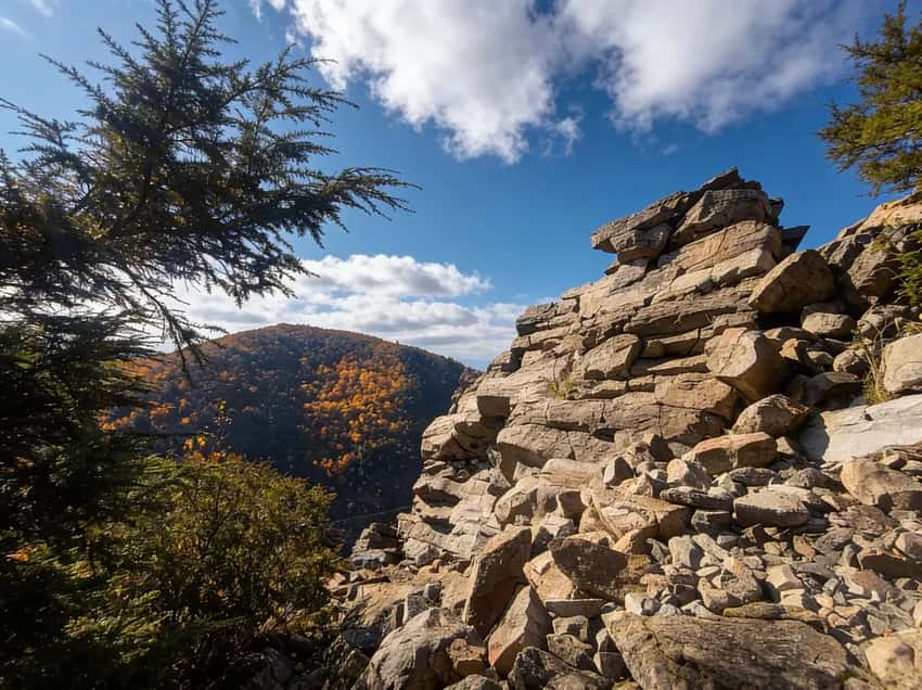
If You Want a Challenge: Lehigh Gap North Trail (Appalachian Trail)
This is one of the hardest sections of the Appalachian Trail in Pennsylvania. You gain 900 feet in less than a mile, and much of it is hand-over-hand scrambling on exposed rocks. The trail climbs the barren, zinc-scarred north face of Blue Mountain.
This is one of the hardest sections of the Appalachian Trail in Pennsylvania. You gain 900 feet in less than a mile, and much of it is hand-over-hand scrambling on exposed rocks. The trail climbs the barren, zinc-scarred north face of Blue Mountain.
- Distance: 1.8 miles one-way to summit (3.6 miles round trip)
- Elevation: 900 ft gain
- Time: 2-3 hours round trip
- Difficulty: Strenuous (hand-over-hand scrambling, exposed rock)
- Trailhead: Lehigh Gap Nature Center parking lot (off Route 873)
- The View: 360 degrees. On a clear day, you can see the entire Lehigh Valley and beyond.
- Best Time: Spring for wildflowers on the restoration slopes, fall for cooler temps
- Dogs: Leave them at home for the scramble. It’s not safe for paws.
What to Expect: The first half-mile is brutally steep with constant elevation gain. Forget switchbacks, this is a direct climb. Your legs will burn. The scrambling section (mile 0.8-1.2) requires using your hands.
It’s exposed but not technically difficult. The exposed sections offer no shade and high wind exposure. The final 0.6 miles is a steep but less technical walk to the summit.
The 360-degree view from the top, Lehigh Valley spread out below, ridges extending north and south, is the payoff. Descending is harder than ascending because of the steep terrain and loose rock.
Parking & Logistics: The Lehigh Gap Nature Center lot holds about 30 cars and fills on weekends by 10 AM. Arrive before 9 AM on nice days, or come weekday mornings. There’s overflow parking across Route 873 but it’s limited. Cell service is spotty near the summit.
⚠️ Critical Warning: Do NOT attempt this in rain, ice, or snow. The rocks become lethally slick, people have had serious falls here. This trail exposes you to heights, significant drops, and scrambling on unstable rock.
If you have vertigo or fear of heights, pick the South Trail or stick to the D&L below. Wear stiff boots. Bring extra water, there’s no water on the ridge.
If You Want Distance Without Pain: D&L Trail (Delaware & Lehigh National Heritage Corridor)
The Delaware & Lehigh National Heritage Corridor allows you to crush miles without crushing your knees. The full trail is 165 miles long, but the Lehigh Valley section (approx. 50 miles from Allentown to Jim Thorpe) is the sweet spot, flat, scenic, and multi-use friendly.
- Distance: 165 miles total (Lehigh Valley section: ~50 miles)
- Elevation: Nearly flat (follows the historic canal and river)
- Time: Variable (most people do 10-20 mile sections)
- Surface: Crushed cinder and gravel. Fast for walking, excellent for gravel bikes, decent for trail runners.
- Best Sections by Vibe:
- Allentown to Bethlehem (10 miles): Urban greenway, heavy foot traffic, accessible
- Bethlehem to Easton (12 miles): Historic canal locks, river views, moderate crowds
- Walnutport to Lehighton (15 miles): More remote, quieter, best for solitude
- Scenery: It hugs the Lehigh River. The section from Jim Thorpe to White Haven (Lehigh Gorge) is the most scenic, steep forested ridges on both sides of the river, though technically just north of the valley proper.
- Usage: Multi-use (walkers, cyclists, trail runners). Watch for fast cyclists on weekends. Stay right and signal before passing.
What to Expect: The trail is genuinely flat, minimal elevation change except for brief bridge crossings. The surface is well-maintained crushed stone, so it’s fast underfoot. The Lehigh River is constant company on your left. Historic canal locks punctuate the route.
The pace is leisurely, most people do 12-15 miles in 4-5 hours with breaks. Weekdays are much quieter than weekends. The scenery improves the farther north you go, the Allentown section is urban-adjacent, while Walnutport feels genuinely rural.
Parking & Logistics: Multiple parking areas exist along the route. The Allentown lot (near the trailhead) fills early on weekends. Walnutport and Lehighton have ample parking.
The trail is linear, so plan a shuttle if you want to walk one-way (car at endpoint, drop-off at start, or vice versa). Cell service is reliable along the entire route.
Access: Visit D&L Trail for detailed parking maps and access points.
If You Want Urban Wilderness: South Mountain Preserve
Located right in Emmaus/Allentown, this preserve makes you feel miles away from the city despite hearing traffic from Interstate 78 on the south side. Perfect for after-work hikes or weekend trail runs. The preserve has 20+ miles of interconnected trails.
- Distance: 20+ miles of trails (various loops. 2-8 miles typical)
- Elevation: Moderate. 300-500 ft climbs depending on route
- Time: 1-3 hours depending on loop
- Difficulty: Moderate to strenuous (rocky, rooty, typical PA terrain. Some technical sections)
- Best Trails:
- Swabia Creek Trail: 3.5 miles, creek crossings, sustained climb, moderate
- Spring Creek Trail: 2.5 miles, easier, family-friendly, no significant elevation
- Ridge Loop: 5 miles, steady climb, panoramic ridgetop views
- Trailheads: Alpine Street (Emmaus, main), Vera Cruz Road, Spring Creek Road
- Terrain: Rocky and rooty. South Mountain is the gateway to “Rocksylvania”, expect loose rock, exposed roots, technical footing. Trails are well-maintained and marked.
- Parking: Alpine Street lot (main trailhead, ~20 spaces, fills by 11 AM on weekends). Vera Cruz Road and Spring Creek have smaller lots that rarely fill.
What to Expect: The lower trails (Spring Creek) are genuinely easy and good for families. The mid-level routes (Swabia Creek) involve consistent climbing on rocky terrain. The ridge trails offer panoramic views of the Lehigh Valley and, on clear days, visibility toward the Blue Ridge. The forest is mature mixed oak and hemlock.
Expect to see trail runners and dog walkers, especially on weekends. The trail system is interconnected, so you can link sections for custom distances. Water crossings exist in the lower sections but are usually easy rock-hops except after heavy rain.
Vibe: This is a neighborhood park for Allentown/Emmaus hikers. It gets busy on weekend mornings and weekday evenings (after-work trail runners). Weekday mornings are quiet.
If You Want Wildlife: Trexler Nature Preserve
This isn’t your average walk in the woods. The Central Range is home to a free-roaming herd of American bison and elk (fenced, but genuinely wild and visible from the trails). You don’t need a safari to see big game in Pennsylvania.
- Distance: 18+ miles of trails across three ranges
- Terrain: Rolling hills, open meadows, steep slate ridges in North Range
- Difficulty: Easy to moderate
- Highlights: Bison and elk viewing (legitimately present, not zoo-like), wildflower meadows (May-June), forested ridges
- Best Trails:
- Central Range Loop: 3-4 miles, bison/elk viewing, easy, best for families
- North Range: 4-6 miles, steeper, more challenging, slate ridges, fewer crowds
- Birch Run Trail: 2.5 miles, creek-side, gentle
- Parking: Multiple lots across the preserve. Free parking. Central Range lot (~25 spaces) fills on nice weekends by 10 AM.
- Access: Free admission. No permit required. Day-use hours vary seasonally.
- Bonus: Adjacent to Lehigh Valley Zoo (separate admission if interested).
What to Expect: The Central Range Loop is easy and scenic. You’ll see bison grazing (usually from a distance, but sometimes quite close). Elk are more elusive, early morning or dusk are best. The North Range gets more rugged with exposed slate and steeper climbs.
The meadows in May-June explode with wildflowers (trilliums, wild orchids). The preserve feels more like a nature refuge than a typical hiking area, it’s genuinely quiet.
Timing: Early morning (sunrise to 9 AM) and late afternoon (4-6 PM) are prime for wildlife viewing. Midday animals retreat to shade.
If You Want Raptors: Hawk Mountain Sanctuary
Hawk Mountain is world-famous for its fall raptor migration, and for good reason. Over 20,000 raptors pass through each fall. On a good day in September, you’ll see dozens of hawks and eagles from a single overlook. If you’ve never watched a migrating raptor, this is the place.
- Distance: Various trails (Lookout Trail: 2 miles round trip, River of Rocks: 4 miles round trip)
- Elevation: 300-500 ft gain to overlooks (constant climbing)
- Time: 1-3 hours depending on trail
- Difficulty: Moderate to strenuous (rocky, steep sections, relentless climbs)
- Best Trails:
- Lookout Trail: 2 miles round trip to North Lookout (primary raptor viewing platform, most accessible, constantly crowded in fall)
- River of Rocks Trail: 4 miles, boulder field scramble, quieter, excellent for solitude
- Admission: $10-15 per vehicle (rare for PA hiking, but supports conservation and trail maintenance)
- Parking: Main lot (~100 spaces) fills by 10 AM on fall weekends. Secondary lots available but require walking.
What to Expect: The Lookout Trail climbs steadily on rocky terrain to the North Lookout platform, a exposed rocky outcrop with 360-degree views. From September-November, the sky fills with raptors. Broad-winged Hawks (September) move in kettles (large spiraling groups). Red-tailed Hawks (September-October) are constant.
Golden Eagles (November) are the prize sighting, rare but possible. The River of Rocks Trail is more challenging and technical (boulder scrambling) but offers better solitude. The sanctuary provides stools at the overlooks so you can sit and watch for hours.
Species Timeline for Lehigh Valley Hiking:
- Mid-September: Broad-winged Hawk migration peaks. You might see 100+ in an hour on a good day.
- Late September-October: Red-tailed Hawks, Sharpies, Coopers Hawks dominate. This is prime hawk-watching season.
- November: Golden Eagles, Bald Eagles, late migrating raptors. Days are shorter. Fewer sightings but higher quality.
Crowds: October is chaotic. Arrive by 8 AM to get a decent spot at the overlook. Weekdays are dramatically quieter. September and November are less crowded than October.
Timing & Tips: Bring binoculars (essential). Bring a field guide or use the Merlin Bird ID app. The sanctuary provides hawk identification posters at the overlook.
Wear layers, the overlook is exposed and windy. Morning (8-11 AM) and afternoon (2-5 PM) are peak raptor activity times.
Website: Hawk Mountain Sanctuary for migration forecasts, real-time raptor counts, and trail conditions.
If You Want Easy Family Walks: Jacobsburg Environmental Education Center
With 1,000+ acres near Nazareth, Jacobsburg is genuinely easy and genuinely interesting. It combines history (colonial gun manufacturing), creek wading, and old-growth forest. Perfect for families, beginner hikers, and anyone who wants a low-stress outing.
- Distance: 18+ miles of trails (various loops. 1.5-5 miles typical)
- Elevation: Minimal to moderate (mostly flat along Bushkill Creek with gentle rolling hills)
- Time: 1-2.5 hours for most loops
- Difficulty: Easy to easy-moderate
- Best Trails:
- Henry’s Woods Trail: 1.5 miles, old-growth forest loop, very easy, no elevation
- Bushkill Creek Trail: 3 miles, follows the creek, flat, excellent for kids
- Historic Trail: 2 miles, past colonial rifle works ruins and interpretive signs
- Breindy’s Loop: 4 miles, rolling terrain, moderate
- Parking: Free parking at the Environmental Education Center. Large lot (~60 spaces) rarely fills.
- Facilities: Restrooms, water, picnic areas, program building.
- History: The site of colonial gun manufacturing (1755+). Henry family rifle works. You can walk past stone foundations and interpretive signs explaining 18th-century iron production.
What to Expect: The trails are well-maintained and clearly marked. The creek (Bushkill Creek) is reliably present, making this a great choice for kids who want to play in water. The old-growth forest section is genuinely impressive, massive hemlocks and oaks. The trails interconnect, so you can customize distance.
The site is peaceful and less crowded than nearby areas. Early morning is quietest. Afternoon brings families.
Seasonal Detail:
- Spring: Wildflowers peak (May), creek flows strongly from snowmelt, muddy sections possible
- Summer: Creek wading is the main draw. Warm days make it ideal for families. Insect repellent recommended
- Fall: Foliage is excellent, moderate temps, fewer bugs, creek is lower but still good for wading
- Winter: Quiet and peaceful. Creek crossings are easy on frozen sections. Trails are less used
Parking & Access: Free parking. No permit required. Day-use hours vary seasonally. The Environmental Education Center often hosts family programs, check the website if you want structured activities.
Insider Tips: How to Hike Lehigh Valley Like a Local
Parking Hacks for Lehigh Valley Hiking
Lehigh Gap North (AT): The Lehigh Gap Nature Center lot fills by 10 AM on weekends. Arrive before 9 AM or come on weekdays. There’s no overflow parking, when it’s full, it’s full.
D&L Trail: The Allentown trailhead lot is small and fills early. Better option: park at Walnutport or Lehighton (less crowded, free parking, equally scenic). The trail is linear, so plan a shuttle.
South Mountain Preserve: Alpine Street lot (main) fills by 11 AM. Vera Cruz Road and Spring Creek Road have ample parking and access the same trail network.
Hawk Mountain Sanctuary: Main lot (~100 spaces) fills by 10 AM on fall weekends. Secondary lots require walking but are quieter. Go on weekdays if possible.
Trexler Nature Preserve: Central Range lot fills on nice weekends by 10 AM, but it’s rarely completely full. Arrive by 9 AM on Saturday/Sunday. North Range has separate parking and is less crowded.
Seasonal Reality for Lehigh Valley Hiking
Spring (March-May): Mud and water crossings are heavy through April. The creek trails (Bushkill, D&L) are swollen and fast. Wildflowers peak in May at Trexler and Jacobsburg. Ticks emerge in April and are dangerous by May, DEET-based insect repellent is essential.
Summer (June-August): Ridges (Lehigh Gap, South Mountain) get brutally hot and exposed. The D&L and creek trails are shady and cool, prioritize those. Bugs (mosquitoes, gnats, ticks) are heavy. Insect repellent is not optional.
Water sources are reliable. Humidity makes uphill sections harder.
Fall (September-November): Peak hiking season overall, but Hawk Mountain migration season (September-November) brings enormous crowds. Foliage is excellent on ridges (Lehigh Gap, South Mountain). Late October crowds at Hawk Mountain are intense, plan weekdays if possible.
Cooler temps make ridge hiking comfortable. The first frost kills ticks by late November.
Winter (December-March): Ridge trails (Lehigh Gap, Blue Mountain) become dangerous when icy after freeze-thaw cycles. Low-elevation forest trails (Jacobsburg, Trexler, parts of South Mountain) are safer. Microspikes are essential after ice events.
The preserve and creek trails are beautifully quiet in winter. Days are short, plan accordingly.
Safety Notes for Lehigh Valley Hiking
Ticks: This region has serious tick density. April-July is peak season. Use DEET-containing insect repellent (30%+ DEET).
Do a full-body check (including hairline, groin, behind ears) within 2 hours of finishing a hike. Watch for the bullseye rash (erythema migrans), which indicates Lyme disease.
Exposed Rock & Scrambling: Lehigh Gap North is genuinely technical, hand-over-hand scrambling on exposed, unstable rock. The rocks become lethally slick in rain or wet conditions. Do not attempt in rain, ice, or snow.
Wear stiff boots or shoes with aggressive tread. Don’t bring dogs, paws can’t handle the scrambling.
Vertigo Risk: The Lehigh Gap North scrambling section exposes you to heights and significant drops. If you have fear of heights or vertigo, pick the South Trail or stick to the D&L Trail.
Hunting Season: Much of the ridge (Blue Mountain) is State Game Lands (SGL 168 and 217). Hunting season runs October 1 - January 31 (approximately), plus spring gobbler season (April-May). During hunting season, wearing fluorescent orange is legally required and smart. Wear a bright orange vest or orange hat, you will see hunters on the ridge, especially in rifle season (November-December).
Rock-Plate Footwear: “Rocksylvania” isn’t a joke. The AT section along the ridge and rocky trails (South Mountain, parts of Trexler) are brutal on footwear. Trail runners are fine for the D&L and gentler trails, but for rocky terrain, recommend shoes with rock plates or sturdy boots. Many people go through soles fast here.
Weather Changes: Mountain ridges (Lehigh Gap, South Mountain) experience rapid weather changes. Temperature can drop 10°F in 15 minutes. Bring a windproof jacket even if the forecast looks clear. Afternoon thunderstorms are common in summer.
Camping & Lodging
Camping: The Lehigh Valley doesn’t have major campgrounds within the urban core. For camping, head to:
- Hickory Run State Park (30 miles north): 381 sites, electric hookups available, $20-30/night
- Delaware Water Gap NRA (25 miles east): Primitive camping at designated sites
- Dispersed camping: Limited options on State Game Lands (check DCNR regulations)
Lodging: Allentown, Bethlehem, and Easton have extensive hotel options. For a unique stay, consider historic B&Bs in Bethlehem’s downtown or Jim Thorpe (30 miles north).
Nearby: Jim Thorpe (30 miles north) is the outdoor recreation hub with bike rentals, rafting outfitters, and trail access to Lehigh Gorge State Park.
Best Time for Lehigh Valley Hiking
- Fall (Best for Raptors & Foliage): The peak season for Lehigh Valley hiking. Raptors at Hawk Mountain (September-November, peak mid-September for Broad-winged Hawks, November for Golden Eagles), foliage turning the ridges red and orange (typically mid-October, peak around October 10-20), and cool air makes the scrambles bearable. Fall Lehigh Valley hiking is unbeatable. Book Hawk Mountain early for weekends.
- Spring (Best for Wildflowers): The Lehigh Gap’s restoration efforts mean wildflowers bloom on the rocky slopes (late April to May). Spring Lehigh Valley hiking offers moderate temperatures and moderate crowds. The D&L is perfect for long walks without summer heat.
- Summer (Best for Shaded Trails): It gets hot and humid in the valley. For summer Lehigh Valley hiking, stick to the shaded D&L or hit South Mountain early in the morning. Trexler is great for early morning wildlife viewing before heat sets in.
- Winter (Best for Solitude): Avoid the exposed scrambles (Lehigh Gap) if there’s any chance of ice. Winter Lehigh Valley hiking on low-elevation trails (D&L, Jacobsburg, parts of South Mountain) is often pleasant and empty. South Mountain and Jacobsburg are quiet and peaceful in winter.
Photography Tips for Lehigh Valley Hiking
Lehigh Gap North Trail offers the most dramatic shots in Lehigh Valley. The barren, zinc-scarred slopes create a unique moonscape. The stark white face is instantly recognizable. Shoot in late afternoon for dramatic shadows on the exposed rock.
Spring wildflowers add color to the restoration areas. This is the signature Lehigh Valley hiking photo location.
Best River Photography: D&L Trail along the Lehigh River is perfect for Lehigh Valley hiking photography. Morning mist rises from the river in fall. The section near Walnutport offers classic river-and-ridge compositions. The flat towpath allows for creative compositions impossible on ridge trails.
Best Raptor Photography: Hawk Mountain North Lookout is world-famous for raptor photography during Lehigh Valley hiking season. Bring a telephoto lens (400mm+) for raptors in flight. Peak migration is mid-September (Broad-winged Hawks) and November (Golden Eagles).
Arrive early for the best light and positioning. The overlook crowds also mean you’re never alone while shooting.
Fall Foliage for Lehigh Valley Hiking: Blue Mountain ridges peak around October 10-20. Shoot from Lehigh Gap overlook or Hawk Mountain for expansive views. Late afternoon light is best. The combination of barren rock and fall foliage is unique to this region.
Wildlife Photography: Trexler Nature Preserve for bison and elk is the specialty for Lehigh Valley hiking wildlife shots. Early morning or late afternoon offers the best light and animal activity. Bring a telephoto lens (200mm+). The composition of massive animals against forested ridges is compelling.
FAQ
Is hiking free in the Lehigh Valley? Generally, yes. State Parks (Jacobsburg), Nature Centers (Lehigh Gap, Trexler), and the D&L are free. Hawk Mountain is the notable exception with an admission fee.
Where can I see waterfalls? You won’t find major waterfalls in the Lehigh Valley proper. You need to head north to the Poconos for that. Local spots might have small trickles after rain, but nothing like Ricketts Glen.
Are dogs allowed? Yes, on the D&L, South Mountain, and most trails. We strongly recommend against taking dogs on the technical rock scrambles at Lehigh Gap. It’s too dangerous for them.
Explore More
- Visit Lehigh Gap Nature Center for trail maps, restoration info, and Appalachian Trail updates
- Explore the D&L Trail official site for maps, access points, and events
- Check out Hawk Mountain Sanctuary for raptor migration forecasts and trail conditions
- Visit Ricketts Glen State Park for Pennsylvania’s best waterfall hikes (1 hour north)
- Explore the Poconos for more waterfalls and family-friendly trails
- Check out the PA Grand Canyon for another rugged gorge experience
- See the full PA State Parks list for more hiking ideas