The Best Hikes Near Philadelphia: From Urban Gorges to Mountain Escapes (2026)
Discover the best hikes near Philadelphia. We cover everything from the Wissahickon Valley to the Delaware Water Gap. Get trail guides, parking hacks, and safety tips for 2026.
Philadelphia is a great hiking paradox. You are surrounded by wilderness but it doesn’t always feel that way.
The good news is that some of the best hiking starts within the city limits. The best mountain views in the region are only 90 minutes away. Whether you are car-free or parking-averse, this guide maps the trails that actually deliver.
Key Takeaways
- Navigation: Wissahickon Valley Park has 57 miles of trails within city limits. Start at Pachella Field (6839 Henry Ave) to avoid crowds. Take SEPTA to access transit-friendly trailheads around the suburbs.
- Best Season: Spring through Fall. Avoid Mt. Tammany on summer weekends after 8:00 AM due to parking constraints.
- Distance & Difficulty: Variable. Options range from the 3.5-mile easy John Heinz loop to the strenuous 3.8-mile Mt. Tammany rock scramble.
- Hazards: Mt. Tammany lots fill by 8:00 AM. Wissahickon’s Valley Green Inn is a car break-in target. Use designated lots and keep valuables out of sight.
- April 2026 Alert: Mt. Minsi’s cliff viewpoints are closed for peregrine falcon nesting. Stay on the main AT trail to protect nesting birds.
Hiking Without Leaving the City: Wissahickon Valley Park
The Wissahickon Valley Watershed Association helps maintain these trails. Most people start with Wissahickon Valley Park’s Forbidden Drive. This is the paved path that runs along the creek for over 5 miles. It is beautiful and accessible. But it is not the real Wissahickon experience.
The real hiking happens on the orange and white blazed trails. These climb the ravine walls and offer genuine terrain challenges.
The problem: Forbidden Drive is crowded on weekends. The parking lots fill fast. But if you park smarter, you unlock 57 miles of actual hiking that most tourists never discover.
Distance & Difficulty
- Forbidden Drive (paved): 5.2 miles, flat, easy
- Orange Trail (ravine loop): 4.1 miles, moderate elevation, rocky technical sections
- White Trail (ridge connection): 2.8 miles, strenuous scrambling, ridge views
- Combined Orange-White Loop: 6.5 miles, moderate-strenuous, highly rewarding
The Parking Hack
Don’t start at Valley Green Inn. Instead, park at Pachella Field (6839 Henry Ave, Philadelphia, PA 19128). It is only 0.3 miles from the trailhead and rarely fills up. From there, you hit the orange trail immediately and avoid the main crowds.
Valley Green Inn is a known target for car break-ins. Thieves look for hikers who leave bags visible or even just run the AC while they pack up. The Pachella Field lot is brighter and better policed. It lets you start your hike on real terrain instead of asphalt.
What to Expect
The orange trail climbs steeply from the creek. It offers water views and occasional overlooks. The terrain is rocky. Loose shale and river rocks create technical footing, especially when it is wet in the spring.
If you have hiked the Wissahickon before and thought it was just a walk, the orange trail will change your mind.
The white trail connects from the upper ravine. This is where the scrambling begins. You will use your hands occasionally on the climb.
The ridge section feels like you have left the city entirely. It is just trees, stone, and the quiet that comes with elevation.
Best Season & Safety
Spring and fall are prime. Summer is hot and buggy (bring bug spray). Winter is doable but icy in the ravine where shade keeps frost on the rocks.
Ticks are heavy here. It is a wooded ravine with low brush. Check yourself thoroughly after this hike.
Car-Free Hiking: SEPTA Regional Rail to Real Trails Near Philadelphia
If you don’t have a car, Philadelphia’s regional rail network opens up surprising options. You can access high-quality trails without needing a vehicle.
The Media/Elwyn Line: Wawa Preserve (20 minutes from Center City)
Take the SEPTA Regional Rail Media/Elwyn Line to the Wawa Station. The trailhead is a short walk north from the platform.
What you get: Eight miles of interconnected trails through preserved farmland and woodlands. This is lower-elevation hiking without big views. But it is peaceful and well-marked. It gives you genuine forest immersion without the Wissahickon crowds.
Distance: 4-6 miles depending on which loops you connect
Difficulty: Easy to moderate
Best for: Beginners, families, car-free hikers
The Lansdale/Doylestown Line: Green Ribbon Trail (35 minutes from Center City)
Take the Regional Rail to North Wales Station. From there, it is a half-mile walk to Upper Gwynedd Township Park (1 Parkside Pl, North Wales, PA 19454).
This is a quiet spot. The Green Ribbon Trail is a 4.5-mile loop through restored woods and wetlands. It is marked clearly and offers enough ecological interest to keep bird watchers entertained for hours.
Distance: 4.5 miles
Difficulty: Easy to moderate
Best for: Nature photography, bird watching, car-free hikers
Parking: Free lot adjacent to trailhead
The 1-Hour Suburban Ring: Best Hikes Near Philadelphia (30-45 Minutes Away)
If you are willing to drive 30 to 45 minutes, the quality of trails jumps significantly. You will find more elevation gain and mountain scenery.
Valley Forge National Historical Park: Mt. Joy & Mt. Misery Loop
Valley Forge National Historical Park is famous as a Revolutionary War encampment. But hikers know it for the wooded terrain and the ridge section.
The Route: Start at the Visitor Center and take the Joseph Plumb Martin Trail up to Mt. Joy. You’ll get a modest elevation gain with decent views.
Continue on the wooded ridge trail to complete the loop. This seven-mile trek gives you the feeling of leaving the suburbs.
Distance: 7 miles (can be shortened to 4)
Difficulty: Moderate
Elevation Gain: 700 feet
Best Season: April through October (winter can be muddy)
Parking: Free lots at the Visitor Center (1400 N Outer Line Dr, King of Prussia, PA 19406). Arrive by 09:00 on weekends to guarantee parking.
Ringing Rocks County Park (Bucks County): The Geological Oddity
Ringing Rocks (Ringing Rocks Rd, Upper Black Eddy, PA 18972) is a geological anomaly. It is a 15-acre field of boulders that ring like bells when struck with a hammer. It is not a serious hiking destination. But it is a fun loop with a hidden waterfall.
Bring a hammer if you want to make the rocks sing. The effect is real and genuinely delightful. (If you want to focus more on the water features, check out our Complete Guide to Pennsylvania Waterfall Hikes).
Distance: 2-3 miles
Difficulty: Easy to moderate
Best for: Families, a quirky Philly-area adventure
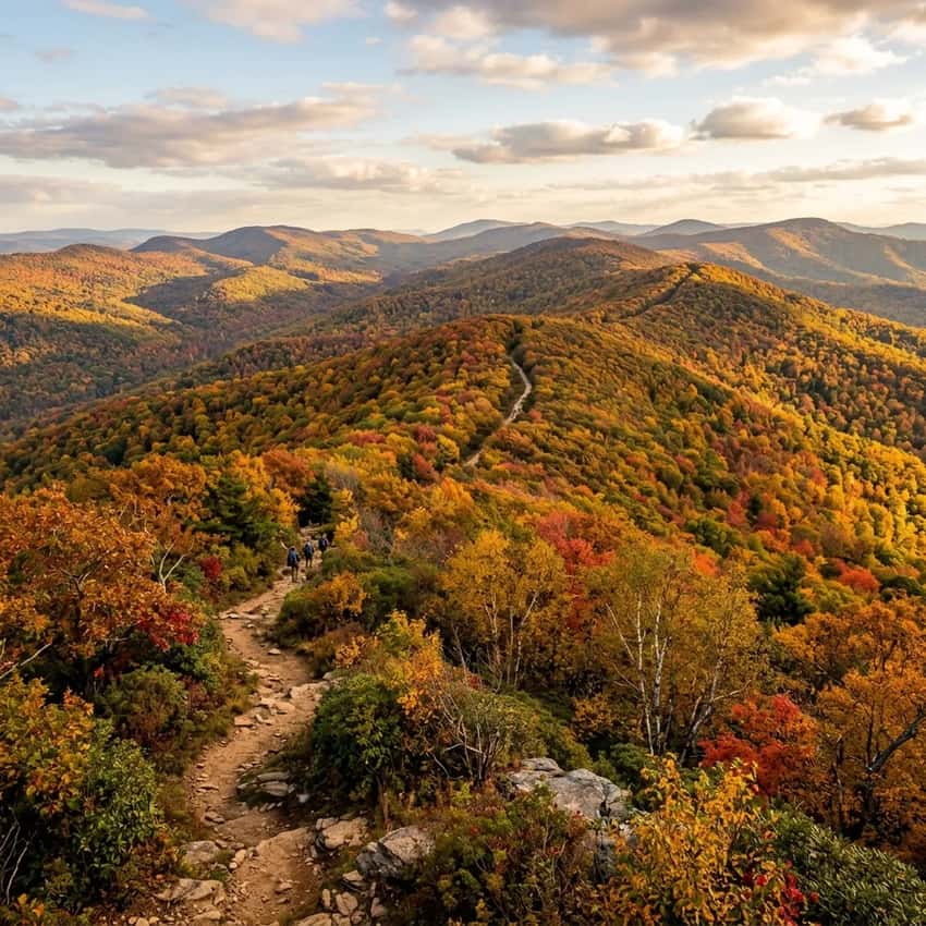
The Mountain Payoff: Best Mountain Hikes Near Philadelphia (Delaware Water Gap, 90 minutes away)
If you’re willing to drive 90 minutes from Philadelphia, you get real mountain hiking with legitimate views. The Delaware Water Gap National Recreation Area offers two of the most iconic hikes near Philadelphia: Mt. Tammany and Mt. Minsi, which anchor the broader Delaware Water Gap Regional Hiking Guide.
Mt. Tammany: The Red Dot / Blue Dot Loop
Mt. Tammany is the flagship Philadelphia mountain hike. At 1,461 feet, it is not tall by Appalachian standards. But the rocky approach and ridge views make it feel substantial.
The biggest challenge is parking. The Dunnfield Creek lot on the New Jersey side often fills by 8:00 AM on weekends. If you arrive late, you’ll likely spend 20 minutes circling before leaving frustrated.
The Hack: Use the Kittatinny Point Visitor Center lot (Columbia, NJ 07832) on the New Jersey side. It is about 2 miles south of the main lot. It’s a longer walk to the trailhead, but it is rarely full. You still get to spend your day on the mountain.
The Hike:
The Red Dot trail is the steep approach. It is less than a mile of brutal rocky scrambling. You will use your hands frequently.
The rocks are sharp shale. Bring good boots with ankle support. Halfway up, there is a false summit that looks like the top but isn’t. Keep climbing.
From the true summit, the view opens to the Delaware River winding below. You’ll see New Jersey ridges to the east and Pennsylvania forest to the west. On a clear day, you can see 20 miles or more.
The return is the Blue Dot trail. This path descends more gently through hemlocks. It offers a different perspective on the gap.
Distance: 3.8 miles total (Red Dot up, Blue Dot down)
Difficulty: Strenuous (rocky scrambling, 1,000+ ft elevation gain)
Elevation Gain: 1,040 feet
Best Season: April-October (March and November can be icy on rocks)
Safety Alerts:
- Bring boots with good support. The shale is sharp.
- Microspikes in winter are non-negotiable.
- Bring more water than you think you need. There are no reliable sources on the mountain.
- Start early. Weather changes fast on the ridge.
Mt. Minsi: Pennsylvania’s Perched Lookout (CLOSED APRIL-MID JULY 2026)
Mount Minsi is Mount Tammany’s quieter sibling. It offers similar rocky terrain and views from the Pennsylvania side. However, in 2026, the cliff viewpoints are closed for peregrine falcon nesting from April through mid-July.
Peregrine falcons nest on the cliff faces. Human presence near the overlooks can cause them to abandon their nests. To protect the birds, stay on the main Appalachian Trail. Avoid the cliff-side viewpoints during this period.
If visiting after mid-July: The hike is 3.2 miles out-and-back from the AT. You’ll gain 900 feet in elevation. The views from the main lookout are excellent. It is typically less crowded than Mount Tammany.
Best Season for Mt. Minsi: August-October (nesting closure ends mid-July, but early August is warmest)
Quick Reference: Philadelphia-Area Hikes Ranked by Difficulty
- John Heinz Wetland Loop: 3.5 mi | Easy | Beginners, families, car-free | 20 min from Philly (SEPTA)
- Wissahickon Forbidden Drive: 5.2 mi | Easy | Casual strolls, dog walks | 15 min from Philly
- Wawa Preserve Loops: 4-6 mi | Easy-Moderate | Car-free hikers, bird watchers | 20 min from Philly (SEPTA)
- Green Ribbon Trail: 4.5 mi | Easy-Moderate | Nature walkers, photographers | 35 min from Philly (SEPTA)
- Wissahickon Orange Trail: 4.1 mi | Moderate | Strong hikers, scrambling | 15 min from Philly
- Valley Forge Mt. Joy Loop: 7 mi | Moderate | Day hikers, scenic walks | 45 min from Philly
- Ringing Rocks: 2-3 mi | Easy-Moderate | Families, geological quirks | 50 min from Philly
- Mt. Tammany Red/Blue Loop: 3.8 mi | Strenuous | Experienced hikers, rock scrambling | 90 min from Philly
- Mt. Minsi: 3.2 mi | Strenuous | Mountain views, fall foliage | 90 min from Philly
Getting There: No-Car Options & SEPTA Tips
Pro tip: Get a SEPTA Key Card and check the latest SEPTA Regional Rail Schedule beforehand. Monthly passes are usually cheaper than paying per ride. You can use them on buses, subways, and Regional Rail.
Regional Rail Lines with Trailhead Access
| Line | Destination | Trailhead | Est. Transit Time |
|---|---|---|---|
| Media/Elwyn | Wawa Station | Wawa Preserve | 20-25 min |
| Lansdale/Doylestown | North Wales Station | Green Ribbon Trail | 30-35 min |
| Chestnut Hill West | Chestnut Hill Station | Wissahickon via local access | 15-20 min |
For Mt. Tammany and Mt. Minsi, you’ll need a car (or a rideshare for 90 minutes + hike + 90 minutes back, which gets expensive).
What to Bring: Philadelphia-Area Hiking Essentials
For easy to moderate trails (Wissahickon, Valley Forge, Wawa):
-
Water (2 liters minimum)
-
Sun protection (sunscreen, hat)
-
Bug spray (April-September). Ticks are serious here.
-
Good shoes with ankle support (roots and rocks everywhere)
-
Trash bag (pack out what you pack in)
For strenuous trails (Mt. Tammany, Mt. Minsi):
- All of the above, plus:
- Proper hiking boots (ankle support is essential for rocky scrambling)
- Microspikes (December-March for icy rock sections)
- Headlamp. Even if you don’t plan to hike in the dark, weather changes fast.
- Extra water. Bring 1.5 liters per person. There are no water sources on the mountain.
- First aid kit. The rocks are sharp and cuts happen.
Safety Alerts & Current Conditions (April 2026)
Ticks
Tick season is year-round in Pennsylvania. April through September is peak. After any hike, especially in the Wissahickon, check yourself thoroughly. Ticks in Pennsylvania often carry Lyme disease.
Car Break-Ins
The Wissahickon’s Valley Green Inn lot is a known target. Don’t leave bags visible. Park at Pachella Field instead. The Mt.
Tammany Dunnfield Creek lot can also be targeted. Never leave valuables in your car.
Weather & Seasons
- April-May: Muddy and buggy but with beautiful wildflowers.
- June-August: Hot and humid. Start your hikes by 7:00 AM to avoid midday heat.
- September-October: Perfect hiking weather. All trails are excellent. Expect heavy crowds at Mt. Tammany.
- November-March: Icy rock sections are common. Mt. Tammany requires microspikes.
2026-Specific Alerts
-
Mt. Minsi cliff viewpoints: Closed April-mid July for peregrine falcon nesting
-
SEPTA Wawa Station: New in 2025. Check schedules on SEPTA.org before your trip.
-
Valley Forge: Military encampment sites are part of the park. Respect roped-off historical areas.
Planning Your First Philadelphia-Area Hike: Where to Start
If you’re new to hiking near Philadelphia, start with one of these best hikes near Philadelphia based on your experience level:
- No experience, car-free: John Heinz Wetland Loop or Green Ribbon Trail (easy, well-marked, SEPTA access)
- Some experience, no car: Wissahickon Forbidden Drive (flat, scenic, very accessible hiking near Philadelphia)
- Regular hiker, want views: Valley Forge Mt. Joy loop or Mt. Tammany if you’re comfortable with scrambling
- Want to test your fitness: Mt. Tammany Red Dot scramble offers some of the most challenging hiking near Philadelphia, but the summit view is worth every step
Ready to Explore the Best Hikes Near Philadelphia?
Philadelphia is surrounded by better hiking than most realize. Whether you want a quick urban escape or a mountain adventure, there is a trail that fits. Start with the Wissahickon if you are in the city. Drive to Valley Forge for something more serious.
If you are willing to go 90 minutes to the Delaware Water Gap, Mt. Tammany will remind you why you love hiking. The mountain views are worth every step of the climb. (You can also review the PA Department of Conservation & Natural Resources (DCNR) for broader state-wide hiking regulations).
Pack light, start early, and respect the trails. The more people who hike responsibly, the longer these places stay beautiful. Don’t forget your tick check.
Have you hiked any of these trails? Share your recent conditions, parking tips, or favorite lesser-known routes in the comments. Local knowledge is what makes hiking better for all of us.
FAQ: Hiking Near Philadelphia
Can I hike Mt. Tammany without a car? Not practically. Driving is the only realistic option.
Is the Wissahickon safe for solo hikers? Yes. Hike during daylight and stick to marked trails. The orange and white trails are well-traveled on weekends. Avoid hiking alone at dawn or dusk.
Can I bring my dog? Yes on most trails. The Wissahickon and Valley Forge are very dog-friendly. Mt.
Tammany allows dogs, but the rocky scrambling is tough on paws. Booties are recommended.
Is Mt. Tammany worth the drive from Philadelphia? Absolutely, if you enjoy rocky scrambling and mountain views. The 90-minute drive is worth it for the hike itself. Consider making it a full-day trip and exploring the Delaware Water Gap area, or if you’re traveling further west across the state, read our guide to the Best Hikes Near Harrisburg.
Last Updated: April 13, 2026
Next Review: July 2026 (post-falcon-nesting season)