The Best Hikes Near Harrisburg, PA: A Local's 2026 Guide
Discover the best hiking trails near Harrisburg with insider tips on parking, difficulty, and seasonal conditions. From 30-minute local hikes to full-day adventures.
The Susquehanna Valley, heart of South Central PA hiking, is Pennsylvania’s best-kept hiking secret. From iconic ridgeline views of the river-bend at Hawk Rock to the quiet forest loops of the Capital Area Greenbelt, Harrisburg sits at the crossroads of some of the state’s most diverse and accessible trails.
Whether you have 90 minutes or a full weekend, you’ll find a hike here that matches your skill level and what you’re seeking, and most won’t require a 2-hour drive.
Quick answer: The best hikes near Harrisburg are Hawk Rock (iconic Susquehanna view, 1.5 miles), Wildwood Park (urban nature loop, 3.1 miles), Peters Mountain (technical scrambling, 3.7 miles), Detweiler Park (quiet meadows and forest), Cove Mountain (historic viewpoints, 2.5 miles), Boyd Big Tree Preserve (forest depth, 12+ miles), and Pine Grove Furnace’s Pole Steeple (1-hour radius, 1.4 miles). Each offers something distinct, and insider tips can save you hours of parking headaches.
Here’s what makes Harrisburg hiking special: the trails are genuinely close (most within 30 minutes of downtown), the terrain varies from riverside walks to rocky scrambles, and the seasonal timing matters more here than anywhere else in PA. The Susquehanna Valley is wetter and muddier in spring, the ridge routes turn brutal in summer heat, and fall is short but spectacular.
Key Takeaways
- Navigation: For central access to multiple Harrisburg-area loops, use the Wildwood Park lot (Google Maps | Apple Maps). GPS: 40.2589,-76.8789.
- Iconic View: Hawk Rock offers the most famous Susquehanna river-bend panorama. Use the Watershed Drive “parking hack” to save 20 minutes of slog.
- Technical Scrambling: Peters Mountain features rugged Rocky terrain; check Norfolk Southern train schedules before crossing the tracks.
- Urban Escape: Wildwood Park is a premier 3.1-mile nature loop inside city limits, ideal for birdwatching and family weekends.
- Seasonal Logic: The Susquehanna Valley is notoriously muddy in spring. Focus on ridgeline trails like Cove Mountain starting in May.
The 30-Minute Radius: Local Favorites You Can Hit on a Weeknight
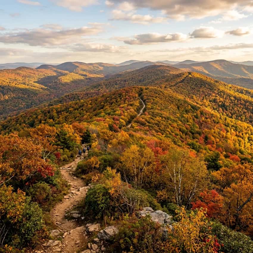
1. Hawk Rock (Duncannon), The Icon
Distance: 1.5 miles round trip | Elevation Gain: 400 feet | Difficulty: Moderate to Strenuous | Parking: Free | Best Season: April-October
Hawk Rock is the Harrisburg hiker’s obligatory pilgrimage. The Susquehanna river-bend view from the ridgeline is genuinely stunning, 250 feet above the water, looking north toward Wormleysburg and the river’s dramatic curve. On clear days you can see 20+ miles.
Here’s the local secret: most hikers park at the official Appalachian Trail crossing on Pennsylvania Route 147 and walk a flat mile along the railroad tracks before even starting to climb.
Skip that. Instead, park at the Watershed Drive gravel lot (off Route 147, just south of Duncannon Bridge). From there, it’s a steep 0.75-mile climb straight up the ridge to the viewpoint. Same view, half the time, and you avoid the flat slog.
The hike: The Watershed Drive parking area puts you directly on the AT blue blazes. The climb is relentless but short, switchbacks lead through dense oak forest, then open suddenly at the ridgetop outcrop. The view is worth every step.
On weekends, expect 20-30 other hikers at the summit, so arrive before 10 a.m. if you want solitude.
What to expect: Rocky footing throughout. The final 200 feet are exposed ledge, nothing dangerous if you’re comfortable with heights, but not ideal for young kids or dogs. Bring water. There’s no reliable source on the trail.
When to go: Spring (April-May) for blooming trillium along the approach. Fall (September-October) for river views without summer haze. Avoid December-March. The shale gets slick and the ledge becomes genuinely risky.
2. Wildwood Park (Harrisburg), Urban Nature
Distance: 3.1-mile loop | Elevation Gain: Minimal | Difficulty: Easy | Parking: Free | Best Season: April-May (birding peak)
Wildwood Park sits inside Harrisburg city limits, you can practically hear the traffic on I-81, yet feels like you’ve driven an hour into the forest. The 312-acre preserve centers on the Benjamin Olewine III Nature Center, with multiple trail loops winding through oak-hickory forest, along Paxton Creek, and through a restored wetland boardwalk.
The main loop is perfect for beginners, families with young kids, and anyone who wants a legitimate nature experience without the drive. The wetland boardwalk is especially good in mid-April when Great Egrets and Wood Ducks are active. Bring binoculars if you care about birding.
The hike: Start at the nature center (parking is easy, never full). The blue loop is the main circuit, it’s mostly flat, well-marked, and breaks nicely if you just want an hour walk or want to combine multiple loops for a full 3-mile tour. The boardwalk section is genuinely beautiful, especially after rain when the wetland is high.
What to expect: Muddy stretches April-May. The creek is crossable but expect wet feet if water is high. Lots of families, so it’s not quiet, but that also means good trail maintenance.
When to go: April-May for peak birding and wildflower bloom. September-October for fall colors without summer crowds.
3. Peters Mountain Loop (Duncannon), The “Rocksylvania” Challenge
Distance: 3.7-mile loop | Elevation Gain: 800 feet | Difficulty: Strenuous | Parking: Free (Clark’s Ferry Park & Ride) | Best Season: September-October
Peters Mountain is where Harrisburg hiking gets technical. The ridge-top rock field is classic “Rocksylvania”, sharp shale, exposed sections, and constant footing attention required. The payoff is genuine wilderness feel just 25 minutes from downtown.
The hike: Park at Clark’s Ferry Park & Ride (Route 147, well-marked). Take the blue-blazed Susquehanna Trail up the spine of Peters Mountain. The first mile is relentless climbing through dense forest, then opens to the rock field with genuine views of the Susquehanna and the agricultural valley below.
Here’s the critical detail: the Susquehanna Trail crosses active Norfolk Southern railroad tracks at the base. Check the rail schedule online before you go (active trains run regularly through the day). Time your crossing when no trains are approaching.
What to make it easier: Use the blue trail up (steeper, more direct) and the yellow trail back (longer, gentler switchbacks). This saves significant knee stress on the descent.
What to expect: Sharp shale cuts into unconditioned boots. Wear proper hiking footwear, trail runners won’t cut it here. The rock field is exposed.
High wind can be legitimately unpleasant. Bring extra water.
When to go: September-October when the heat’s gone and foliage is good. Avoid summer. The ridge gets brutally hot with zero shade.
Avoid winter. The shale is genuinely dangerous when icy.
4. Cove Mountain / Hamer Woodlands Loop (Duncannon), The Viewpoint
Distance: 2.5 miles | Elevation Gain: 400 feet | Difficulty: Moderate | Parking: Free | Best Season: Year-round
Cove Mountain’s main attraction is the Susquehanna Statue of Liberty, yes, a full-scale replica of Lady Liberty carved into the ridge overlooking the river. It sounds gimmicky. It’s actually genuinely cool, especially the Rockville Bridge viewpoint where you can frame the statue, the historic bridge, and the river all together.
The hike combines the green-blazed Cove Mountain Trail with the yellow-blazed Hamer Woodlands loop. The green trail reaches the statue viewpoint. The yellow adds forest depth on the return.
The hike: Start at the Cove Mountain Preserve trailhead (near Duncannon). The green trail climbs moderately through mixed forest, then opens at the statue overlook. The carving is surprisingly detailed. From here, descend via the yellow loop, which winds through deeper forest and returns to the parking area.
What to expect: Well-maintained trail, moderate climbing, no technical sections. The statue area gets busy on weekends, but the yellow loop section is quiet. The overlook has room for photos without crowding.
When to go: Year-round. Spring for wildflowers along the approach. Fall for river views without heat.
Winter is fine. No ice issues on this slope.
5. Boyd Big Tree Preserve (Liverpool), Forest Depth
Distance: 12+ miles of trail options | Elevation Gain: Varies by route | Difficulty: Moderate | Parking: Free | Best Season: April-May (spring wildlife)
Boyd Big Tree Preserve is 360 acres of old-growth oak and hemlock forest, the kind of place where the trees make you feel small. Unlike the ridge hikes, this is pure forest immersion. Multiple loop options mean you can do 2 miles or 6 miles depending on time.
The hike: The Pond Loop is the signature route, a 2.5-mile circuit around a quiet forest pond. Spring is special here. The pond fills with migrating waterfowl, and you’ll see warblers, woodpeckers, and salamanders in the water. Early mornings are best for wildlife.
Longer options branch off for those seeking more mileage. The main trails are well-blazed and easy to navigate.
What to expect: Muddy in spring and after rain. Bugs can be heavy in June-July 9 (bring repellent). The pond itself is scenic but can be shallow in late summer.
No elevation gain. Mostly flat walking.
When to go: April-May for peak wildlife and wildflower bloom. September-October for quiet fall colors. Avoid June-August. Heat and bugs make it less pleasant.
6. Capital Area Greenbelt, Urban Escape
Distance: 20+ miles total. Segment by preference | Elevation Gain: Minimal | Difficulty: Easy to Moderate | Parking: Multiple access points | Best Season: Year-round
The Capital Area Greenbelt is Harrisburg’s answer to Central Park, a multi-mile urban trail system that loops around the city through forests, parks, and greenspaces. You don’t have to do the whole thing. Segment it for the time you have.
The best segment: The Paxtang Parkway section offers the most “forest feel” while staying inside the city. It’s genuinely secluded despite being minutes from downtown. The Wildwood Park connection (see above) makes a nice combo.
The hike: Pick any segment. They’re all well-marked, relatively flat, and perfect for casual walks. The full loop takes 4-5 hours. Most people do 1-2 hour sections depending on entry point.
What to expect: Some sections can be muddy in spring. You’ll share space with cyclists and dog walkers, especially on weekends. No views, but good forest immersion.
When to go: Year-round. Spring for wildflowers. Fall for colors.
Winter is actually pleasant. Fewer crowds and dry ground.
The 1-Hour Radius: Premier Day Trips Worth the Drive
7. Pole Steeple at Pine Grove Furnace State Park (Carlisle), Family-Friendly Summit
Distance: 1.4 miles round trip | Elevation Gain: 400 feet | Difficulty: Moderate | Parking: $5 | Best Season: April-October
Pole Steeple is one of the best short hikes in the region. It’s steep but brief, with an old furnace chimney at the summit and genuine valley views. Unlike Hawk Rock, it’s much less crowded, weekday visitors often have it to themselves.
The hike: The red-blazed trail climbs directly from the parking area. It’s relentless but only 0.7 miles to the summit. The chimney ruin is a nice waypoint, and the view opens toward the Cumberland Valley.
Family tip: If you’re hiking with young kids, take the blue switchback trail on the descent. It’s longer and gentler, avoiding the 45-degree direct descent that kids find intimidating.
The bonus: Pine Grove Furnace is home to the Appalachian Trail Museum, which is excellent. Plan 1-2 hours there. In spring 2026, the museum is open weekends starting in April.
What to expect: Well-maintained trail, good footing. The summit area is open rock with great photos. Bring water. No reliable source on-trail.
When to go: April-May and September-October. Avoid summer heat. Winter is possible but can be icy.
8. Gifford Pinchot State Park (Lewisberry), Spring Wildflowers
Distance: Varies. Alpine Trail is 3.5 miles | Elevation Gain: Moderate | Difficulty: Moderate | Parking: $5 | Best Season: Late April-May (peak blooms)
Gifford Pinchot’s Alpine Trail has the best bluebell display in south-central PA. Peak bloom is late April to mid-May. When it’s right, the forest floor is literally blue, a sight worth timing your schedule around.
Important alert: Route 74 bridge construction is ongoing through 2026. Use the alternate access via Alpine Road instead of the main Route 74 entrance. Add 10 minutes to your drive but avoids construction delays.
The hike: The Alpine Trail is the main loop. It’s a pleasant 3.5-mile circuit through mixed forest, gaining elevation gradually. The bluebell section is concentrated in the middle miles. Early morning is best for photos (light, fewer crowds).
What to expect: The trail can be muddy in spring. Wear boots with good grip. Bring a wildflower guide or download iNaturalist to identify the full spectrum of spring ephemerals.
When to go: Late April-mid-May for peak blooms. Outside that window, it’s a decent but unremarkable forest loop.
9. Ricketts Glen State Park (Dunmore), Waterfall Icon
Distance: 7.2 miles round trip (lower loop) or 10+ miles (full circuit) | Elevation Gain: 1,040 feet | Difficulty: Strenuous | Parking: $5 | Best Season: April-May, September-October
Ricketts Glen is the waterfall destination in Pennsylvania, 21 named cascades stacked along a creek gorge. It’s 2 hours north of Harrisburg, but worth the drive if you have a full day. The lower Falls Trail loop is the most popular (7.2 miles, well-maintained, genuinely stunning).
We’ve written a complete Ricketts Glen waterfall guide if you want the full beta. The short version: go in April when water flow is high, arrive early to beat crowds, bring microspikes if you go December-March (the gorge stays icy), and stay on-trail to protect the vegetation recovering from erosion.
When to go: April-May for peak water flow. September-October for fall colors and lower crowds. Avoid summer. It’s crowded and the heat makes 10 miles miserable.
Insider Tips: How to Hike Harrisburg Like a Local
Parking Hacks
Hawk Rock: Use the Watershed Drive gravel lot instead of the Route 147 trailhead. It’s 20 minutes shorter and puts you right on the AT blue blazes.
Peters Mountain: Clark’s Ferry Park & Ride has ample free parking. Arrive before 9 a.m. on weekends. It can fill up during work commute hours (counterintuitively, even on hiking days).
Wildwood Park: Arrives early on weekends. The parking lot is medium-sized and fills by 10 a.m. on nice days. Weekday mornings are always quiet.
Seasonal Reality
Spring (March-May): Hiking is good but muddy. The Susquehanna Valley is wetter than the ridges. Wildflower blooms peak late April. Bugs emerge mid-May (tick season is in full swing by May).
Summer (June-August): The ridges (Hawk Rock, Peters Mountain, Cove Mountain) get brutally hot. Low-elevation forest trails (Wildwood, Boyd Big Tree) are better. Water sources are more reliable.
Bugs are heavy. Bring insect repellent.
Fall (September-October): Peak hiking season. Cool temps, good footing, stunning foliage. Crowding is moderate. The season is short, peak color lasts 2-3 weeks.
Winter (November-March): The shale ridges become genuinely dangerous when icy. Low-elevation forest trails are fine and beautifully quiet. Bring microspikes if you venture onto exposed rock after freeze events.
Safety Notes
Ticks: All trails in this region have ticks. Use repellent containing DEET, do a full-body check after hiking, and watch for the bullseye rash. Peak season is April-July.
Rattlesnakes: Rare but possible on rocky ridges like Hawk Rock and Peters Mountain. They’re not aggressive. Give them space if you see one. Wear boots and watch for sheltered rocky areas.
Railroad Crossings: Peters Mountain crosses active Norfolk Southern tracks. Check the rail schedule before you go. Use common sense, if a train is approaching, wait.
Hunting Season: Blaze orange (hunter orange) is mandatory October 1-November 15 in Pennsylvania. Wear a bright orange vest on any trail, even if it’s not peak hunting season.
The Takeaway
Harrisburg sits in the sweet spot of Pennsylvania hiking. You’re close enough to hit trails on a weeknight, diverse enough to find something new each season, and well-positioned to explore everything from quiet forest loops to technical ridge scrambles. Local secrets like the ruins at Stony Valley or the Abandoned Pennsylvania Turnpike offer even more variety for those willing to venture just a bit further. The Susquehanna Valley isn’t as famous as the Poconos or Laurel Highlands, but that’s exactly why you can often have these trails to yourself.
Start with Wildwood Park if you want easy and close. Try Hawk Rock if you want the iconic Susquehanna view with minimal drive time. Go to Peters Mountain when you’re ready for technical terrain. And when you want to venture slightly farther, Pine Grove Furnace and Gifford Pinchot are worth the hour drive.
The key is getting outside. The specifics matter less than showing up early, bringing water, and respecting the trails. Happy hiking.
FAQ
Can I hike these trails in winter? Forest trails like Wildwood and Boyd Big Tree are fine year-round. Avoid exposed ridges like Hawk Rock and Peters Mountain December-March unless you have microspikes. The shale gets slick and genuinely dangerous.
Are these trails dog-friendly? Most are. Keep dogs on-leash on Wildwood Park (park rules). Peters Mountain’s railroad crossing is risky for dogs. Use caution.
Forest trails like Boyd Big Tree are fine for dogs. Always carry water for your dog.
What’s the best time to visit? Late April-May for wildflowers and water flow (but muddy and buggy). September-October for cool temps, fall colors, and moderate crowds. Avoid summer on ridges (too hot) and winter on exposed rock (ice hazard).
How early should I arrive to avoid crowds? Arrive before 9 a.m. on weekends for Hawk Rock and Wildwood Park. Peters Mountain and Cove Mountain rarely get packed. Weekday mornings are always quiet.
Do I need special gear for these hikes? Proper hiking boots are essential for rocky trails (Hawk Rock, Peters Mountain, Cove Mountain). Trail runners are fine for forest loops. Bring water for all. Trekking poles help on technical descents.
Are permits required? No. All of these trails are free or have minimal state park fees ($5 for Pine Grove Furnace, Gifford Pinchot, Ricketts Glen). No advance permits needed.
Last updated: April 2026. Trail conditions change seasonally. Check @context/south-central-pa for regional updates and @appalachiantrail.org for AT-specific information.