Best Hikes Near Pittsburgh PA: 12 Trails (2026 Guide)
Discover the best hikes near Pittsburgh with real parking info, difficulty ratings, and what to expect. Easy trails to strenuous ridges, all within an hour of the city.
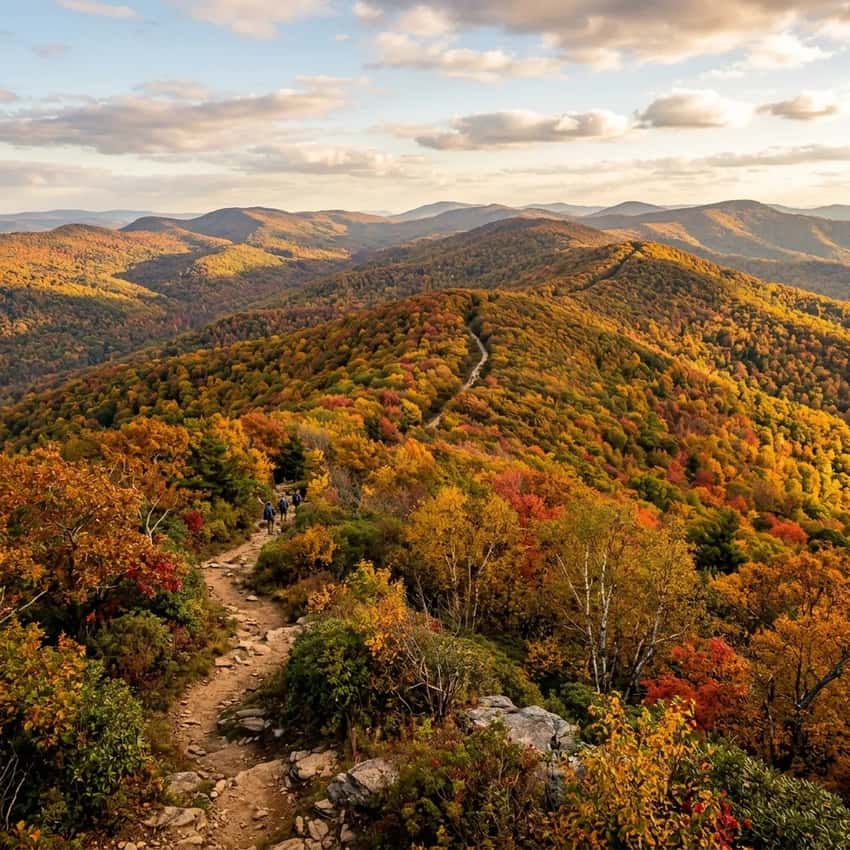
The best hiking near Pittsburgh ranges from easy creek walks to strenuous ridgeline scrambles, and most are within 30-60 minutes of the city. Whether you’re a beginner looking for a weekend walk or a serious hiker seeking technical terrain, Pittsburgh’s proximity to the Laurel Highlands and Allegheny National Forest means world-class trails are closer than you think.
Here’s what makes Pittsburgh a hiking hub: You’ve got the Youghiogheny River Gorge with its dramatic waterfalls, sandstone cliffs, and whitewater views.
You’ve got the Laurel Ridge, a high-elevation spine of Pennsylvania that rewards you with views for miles. You’ve got state forests with minimal crowds compared to the Poconos or eastern PA. And you’ve got parking that actually exists, unlike some of the Instagram-famous trails two hours north.
This guide covers 12 essential hikes near Pittsburgh, organized by distance and difficulty. Each includes honest parking logistics, real difficulty calibration, and what makes the trail worth your time.
Key Takeaways
- Navigation (Primary Hub): For the best trails, navigate to the Ohiopyle State Park Visitor Center (Google Maps | Apple Maps). GPS: 39.8690, -79.4842.
- The Crown Jewel: Ohiopyle State Park (45 mins away) offers the region’s best gorge hiking, from Cucumber Falls to the treacherous Youghiogheny walls.
- Ridge Running: The 70-mile Laurel Ridge Trail is the ultimate ridgeline experience. Start with the Roaring Run section for easier access.
- Crowd Control: McConnells Mill is spectacular but fills by 10 AM on weekends. Visit on a Tuesday-Thursday to have the sandstone cliffs to yourself.
- Footwear Strategy: Southwest PA shale is sharp but less brutal than eastern “Rocksylvania.” Sturdy boots are still mandatory for gorge descents.
Why Pittsburgh Is a Hiking Gateway
Pittsburgh sits in the sweet spot of Pennsylvania’s outdoor geography. You’re south and west of the crowded Poconos, close enough to the Laurel Highlands to day-trip into mountain terrain, and within reach of Allegheny National Forest’s remote backcountry.
The hiking culture here is different too. Pittsburgh hikers tend to be serious, this is a region with strong trail maintenance, active hiking clubs, and locals who take Leave No Trace seriously. That said, trails near the city do fill up on weekends, especially during spring and fall.
Summer is hot and humid (90°F+ is common by July). Fall foliage peaks late September through early October. Winter is mild compared to northern PA, but ice on shale and stream crossings is still a hazard December through March. Spring is muddy, many southwest PA trails stay waterlogged through May.
Close by Difficulty: Easy Hikes (Under 5 Miles)
1. Cucumber Falls Trail, Ohiopyle State Park (45 min south)
Quick Facts
- Distance: 2.2 miles round trip
- Elevation Gain: 300 feet
- Difficulty: Easy (some steep sections, but short and manageable)
- Parking: Large lot, usually full by 10 a.m. on weekends. Arrive by 9 a.m.
- Trail Condition: Well-maintained, clear blazes
- Best Season: Year-round. Avoid ice patches December through March
Why This Trail
Cucumber Falls is the gateway hike for Pittsburgh-area beginners. The trail descends through hemlock forest to a 30-foot waterfall that drops into a small pool. On hot days, the spray is worth the walk alone.
Here’s what makes this trail special: it’s short enough for first-timers and young kids, but it feels like real hiking. You’re not just walking. You’re descending into a gorge with trees that block out the sky.
The creek noise builds as you go down. When you round that final bend and see the falls, there’s that moment of reward that makes people want to hike again.
The trail is rocky in sections with loose stone and roots. Wear proper hiking boots or trail runners instead of street shoes. The descent is steep enough that coming back up will make your quads remind you they exist, especially if you’re out of shape. Plan 45 minutes down and 60 minutes back up.
On crowded days, which is most weekends, you’ll share this trail with families, tour groups, and photographers. Go early or in fall to avoid the peak crowds.
Parking Reality: The lot at the Ohiopyle State Park entrance fills by 10 a.m. on nice weekends. Arrive before 9 a.m.
or expect to wait 20-30 minutes. There’s overflow parking a quarter-mile away on a dirt lot.
2. Mill Run Trail, Near Fallingwater (45 min south)
Quick Facts
- Distance: 1.8 miles round trip (can extend to 5+ miles)
- Elevation Gain: 150 feet
- Difficulty: Easy (moderate if extended to Lower Falls)
- Parking: Small lot near Fallingwater. Fills quickly on weekends
- Trail Condition: Clear, well-maintained
- Best Season: Spring through fall. Watch for winter ice hazard on stream crossings.
Why This Trail
Mill Run Trail connects Frank Lloyd Wright’s Fallingwater, one of the most iconic buildings in America, to actual hiking. If you’re already visiting Fallingwater (which is worth the trip for architecture alone), the trail is a perfect add-on. If you just want the hiking, you can skip Fallingwater and go straight to the Mill Run trailhead.
The trail follows a beautiful stream through hemlock and rhododendron. The water is cold and clear. If you extend the hike to Lower Mill Run Falls, it’s a short bushwhack to a 20-foot cascade. Most people do the easy 1.8-mile out-and-back, but the trail actually connects to longer routes in Laurel Highland State Park.
This is a good “second hike” for beginners, slightly more adventurous than Cucumber Falls, but still very manageable.
Parking Reality: Lot capacity is limited if you’re just hiking (Fallingwater visitors get priority). Check if the lot is full before driving down. Nearby street parking on Route 381 is available but not ideal.
3. Yellow Creek Falls Trail, Cook Forest (90 min north)
Quick Facts
- Distance: 2.1 miles round trip
- Elevation Gain: 200 feet
- Difficulty: Easy
- Parking: Ample parking at Cook Forest State Park
- Trail Condition: Well-maintained, clear blazes
- Best Season: Year-round
Why This Trail
Cook Forest is home to some of western PA’s most pristine environments. It has some of the most impressive hemlock forest in the state. The old-growth pines make you feel like you’re hiking in the Pacific Northwest instead of southwestern Pennsylvania.
Yellow Creek Falls is a modest 20-foot cascade. It is beautiful in spring when water volume is high. The trail is easy and well-signed.
The parking lot rarely fills up even on weekends. This is a great option if you want the waterfall experience without the Cucumber Falls crowds.
The forest here is special. Massive hemlocks create a shaded canopy that keeps things cool even in summer heat. Rhododendron blooms in late May and early June. This is also excellent for fall foliage.
Worth Knowing: Cook Forest also has the Scenic Vista Trail if you want to extend your day. The park is less crowded than Ohiopyle, which makes it a solid alternative for weekends.
Moderate Hikes: Mix of Distance & Elevation (5-10 Miles, 500-1,500 Feet Gain)
4. Ferncliff Peninsula Trail, Ohiopyle State Park (45 min south)
Quick Facts
-
Distance: 5.5 miles round trip (can be shortened to 3.5 miles)
-
Elevation Gain: 600 feet
-
Difficulty: Moderate (rocky sections, some steep climbing)
-
Parking: Same lot as Cucumber Falls. Fills by 10 a.m. on weekends.
-
Trail Condition: Well-maintained, blazes clear except in winter
-
Best Season: Spring through fall
Why This Trail
If Cucumber Falls is the gateway, Ferncliff is the next step up. This trail climbs away from the crowds into Laurel Highland forest. It offers solitude and genuine mountain hiking without the “Rocksylvania” leg-crusher reputation of eastern PA.
Ferncliff ascends steadily but never gets brutal. The trail is rocky. Expect loose stone and roots.
The rocks here are sandstone and shale, not the razor-sharp glacial chunks of the Poconos. Your knees will feel the elevation gain on the way back down, but it’s not technical scrambling.
What makes Ferncliff special is the mix: forest, creek crossings, vista points, and genuine elevation. On a clear day, you get mountain views from several points along the trail. The forest canopy is beautiful year-round. Spring wildflowers and fall foliage are peak seasons.
The trail is less crowded than Cucumber Falls because it requires more fitness. That’s why we recommend it. You get Ohiopyle’s gorgeous terrain without waiting in a parking lot.
Trail Notes: The trail is marked with yellow blazes, but some are faded. Follow the well-worn path. You won’t get lost.
There are no water sources on the trail. Bring all the water you need (at least 1.5 liters).
5. Laurel Ridge Trail (Roaring Run Access), Laurel Highland State Park (75 min south)
Quick Facts
- Distance: 5.2 miles (accessible out-and-back from Roaring Run parking)
- Elevation Gain: 700 feet
- Difficulty: Moderate (steady climbing, exposed sections, ridge-top wind)
- Parking: Roaring Run trailhead has small but dedicated parking lot. It is rarely full.
- Trail Condition: Well-maintained, clear blazes
- Best Season: Late spring through early fall. Avoid winter ice on exposed ridges.
Why This Trail
The Laurel Ridge Trail is a 70-mile ridgeline spine running the length of Laurel Highland State Park. The Roaring Run access point gives you a manageable 5-mile section of actual ridge hiking, the kind of view you imagine when you think “Pennsylvania mountains.”
Here’s what you get: a steady climb from the parking area to ridge elevation, then 2+ miles of high-ground hiking with expansive valley views. On clear days, you can see for 20+ miles. The forest transitions from dense hemlock below to open hardwood and wind-sculpted oak at elevation.
The trail is rocky but not brutal. It’s more rugged than Ferncliff, but not “hands on the rock” scrambling. The exposure is real, you’re on a ridgeline with wind and weather changes happening fast, but it’s not cliff-edge scary.
This is an excellent intermediate trail for Pittsburgh hikers who want to step up to real ridge hiking without the technical difficulty of eastern PA’s Appalachian trails.
Weather Alert: Conditions change fast at elevation. Start early and be off the ridge by 3 p.m., even in summer. The ridgeline gets lightning during afternoon thunderstorms.
6. McConnells Mill Loop (40 min northwest)
Quick Facts
-
Distance: 3-4 miles round trip (depending on route)
-
Elevation Gain: 400-500 feet
-
Difficulty: Moderate (rocky sections, some scrambling, narrow gorge hiking)
-
Parking: Decent lot at McConnells Mill pavilion. Occupancy fills on weekends but overflow is available.
-
Trail Condition: Marked with blazes, but rocky and uneven
-
Best Season: Spring through fall (water crossings in high water periods)
Why This Trail
McConnells Mill is a dramatic gorge carved by Slippery Rock Creek. The name is earned. Massive sandstone cliffs, a narrow ravine, and technical rock formations make this feel like real mountain hiking without being strenuous.
The trail options here are varied. The most popular is a loop combining the Slippery Rock Trail, which hugs the creek, and the Rimrock Trail, which sits on top of the gorge looking down. Together, they make a 3-4 mile circuit with constant visual interest.
This trail is deservedly popular. For good reason. The rocks are dramatic. The creek is beautiful.
The scale of the gorge is genuinely impressive. Expect crowds on weekends, but the trail is long enough that you’ll find quiet sections if you hike midweek.
The hiking is technical but not dangerous if you’re careful. Loose rock is common. Wear boots with good ankle support. Stream crossings are easy in summer but can be hazardous after heavy rain.
Know Before You Go: This trail is a Pittsburgh classic. Weekends are busy, especially in fall. The parking lot fills by noon on nice days. Arrive early or go on a weekday.
Strenuous Hikes: Real Distance, Real Elevation (8+ Miles, 1,500+ Feet)
7. High Plateau Trail, Laurel Highland State Park (75 min south)
Quick Facts
-
Distance: 8.2 miles round trip
-
Elevation Gain: 1,400 feet
-
Difficulty: Strenuous (sustained climbing, rocky throughout, minimal crowds)
-
Parking: Small parking area near High Plateau trailhead. It is rarely full.
-
Trail Condition: Well-maintained, blazes clear
-
Best Season: May through October
Why This Trail
High Plateau is the opposite of the Laurel Ridge and Roaring Run hike above. Instead of starting at elevation and staying high, you climb steadily from valley bottom to a high-elevation plateau. The payoff is deep forest, views of ridgelines, and the satisfaction of real elevation gain.
This is a serious hike. The first 3 miles climb 800 feet. It’s relentless. But the trail is consistent.
It’s never technical but always climbing. If you’ve done Ferncliff and want the next step, High Plateau is it.
What makes this hike special is the forest and the quiet. Most Pittsburgh hikers don’t venture here. The trailhead isn’t famous.
The elevation gain discourages casual day-trippers. This means you’re likely to have the trail to yourself mid-week.
The trail is well-maintained and clearly blazed with white blazes. There are no water sources. Carry all the water you need.
The climb is steady enough that you might not stop much. Plan 2.5-3 hours up and 1.5-2 hours down.
8. Jones Valley Trail Loop, Ohiopyle State Park (45 min south)
Quick Facts
-
Distance: 7.8 miles round trip (loop option available)
-
Elevation Gain: 1,200 feet
-
Difficulty: Strenuous (sustained climbing, rocky terrain, creek crossings)
-
Parking: Meadow Run parking area near Ohiopyle. Small lot that fills on weekends by noon.
-
Trail Condition: Well-maintained, clear blazes
-
Best Season: Spring through fall
Why This Trail
Jones Valley is Ohiopyle’s secluded favorite. Serious hikers know it, but casual visitors skip it because it’s not Cucumber Falls. That means you get real Appalachian hiking with minimal crowds.
The trail climbs away from the Youghiogheny River into the high forest. Then it descends into Jones Valley. The views aren’t panoramic, but the forest is pristine and the creek crossings are fun. This is the kind of hike that reminds you why you started hiking in the first place.
Expect rocky footing throughout. Watch for stream crossings in spring and early summer. You’ll find genuine solitude here. This is not a beginner trail.
It requires fitness and footwork. If you’ve tackled High Plateau or Ferncliff and want to explore deeper into Ohiopyle, Jones Valley is the right next step.
What to Know: The parking lot at Meadow Run is small and fills on weekends. Arrive by 8 a.m. or go on a weekday. There are no facilities at the trailhead, so plan accordingly.
Waterfall & Feature Hikes (Best for Photos & Specific Interests)
9. Youghiogheny Gorge Trail System, Ohiopyle (45 min south)
Quick Facts
- Distance: Multiple options, 2-7 miles depending on route
- Elevation Gain: Varies (200-800 feet)
- Difficulty: Easy to Moderate
- Parking: Multiple lots. The largest lot fills by 10 a.m. on weekends.
- Trail Condition: Well-marked, maintained
- Best Season: Year-round. Spring has the highest water volume.
Why This Trail System
The Youghiogheny River carves a gorge through Ohiopyle State Park, it’s a world-class whitewater section (Class III-IV rapids) and also a hiking paradise. The gorge trails are less famous than Cucumber Falls but equally impressive.
You’ve got options here:
- Lower Youghiogheny Trail: Hugs the river, includes Entrance Falls (a 30-foot waterfall cascading directly into the river). Easy to moderate, 4.8 miles round trip.
- Buttermilk Falls Trail: A short cascade near the parking area. Easy, 2.2 miles round trip.
- Meadow Run Loop: A longer option connecting multiple falls and river sections. Moderate, 7+ miles.
These trails are best in spring (April-May) when water volume is highest and the falls are most dramatic. Summer is fine, but the water is often too warm to cascade dramatically. Fall is excellent for foliage plus water flow.
10. Laurel Highland Trail Scenic Sections (30-90 min, depending on access)
Quick Facts
- Distance: Highly variable (1-15+ miles depending on section hiked)
- Elevation Gain: Varies
- Difficulty: Easy to Strenuous (depending on section)
- Parking: Multiple access points
- Trail Condition: Well-maintained throughout
- Best Season: Late May through October
Why This Trail System
The Laurel Highland Hiking Trail is a 70-mile trail running the length of Laurel Highland State Park. Most Pittsburgh day-hikers do 1-2 mile sections rather than the full route. We recommend three specific access points:
- Sproul Point: Dramatic vista point, moderate 5-mile loop
- Jones Camp: Less crowded, 6-mile options
- Toms Run Falls: High-elevation waterfall (rare in PA), 4-mile round trip
Each offers genuine ridge hiking without being overly technical.
Beginner-Friendly but excellent (Why Skip Cucumber Falls)
11. Powdermill Trail, Powdermill Nature Reserve (30 min east)
Quick Facts
- Distance: 2-3 miles depending on route
- Elevation Gain: Minimal (less than 200 feet)
- Difficulty: Easy
- Parking: Small parking area. Rarely crowded.
- Trail Condition: Well-maintained, marked
- Best Season: Year-round. Excellent in spring for migratory birds.
Why This Trail
Powdermill Nature Reserve is Pittsburgh’s best-kept nature secret. It’s a working ecological research station run by Carnegie Museum, not a state park, so it flies under the radar.
The trails here are easy and beautiful. You’ll find a mix of forest, creek, and meadow. The big draw is the birds. Powdermill is a major migration point in spring and fall.
If you care about nature beyond just pretty rocks and views, this reserve is educational and genuinely peaceful.
No crowds, no parking drama, no elevation gain, just quiet walking through excellent habitat.
12. Hartwood Acres Loop (30 min northeast)
Quick Facts
- Distance: 2-4 miles depending on loop chosen
- Elevation Gain: Minimal (under 200 feet)
- Difficulty: Easy
- Parking: Ample parking. Rarely fills.
- Trail Condition: Well-maintained, marked
- Best Season: Year-round. Spring wildflowers and fall foliage are excellent.
Why This Trail
Hartwood Acres was a wealthy Pittsburgh family’s 635-acre estate. Now it’s a county park with trails, meadows, and forest. It’s right on Pittsburgh’s northern edge. It is convenient, never crowded, and offers a surprising sense of solitude for being so close to the city.
The trails wind through different habitats. You’ll find managed forest, native meadow, and old-growth trees. There’s a historic mansion on the property. The grounds feel more like a park than a wilderness, but that’s fine for a beginner hike.
This is an excellent option when you want hiking but don’t want to drive 45 minutes.
Planning Your Pittsburgh Hike
When to Go (Seasonal Considerations)
Spring (April-May)
- Best For: Wildflowers, water volume in waterfalls, mild temperatures
- Watch Out For: Muddy trails, stream crossings, bugs emerging
- Crowds: Moderate. The trails are less crowded than in the fall.
Summer (June-August)
- Best For: Long daylight, reliable weather, kid-friendly (trails aren’t muddy)
- Watch Out For: Heat/humidity (90°F+), afternoon thunderstorms, ticks
- Crowds: High, especially July-August
Fall (September-November)
- Best For: Foliage (peak late September-early October), cool temperatures, lower humidity
- Watch Out For: Orange hunting season. October through January requires blaze orange. Parking lots are crowded during this time.
- Crowds: Extremely high September through October. Quieter in November.
Winter (December-March)
- Best For: Solitude, snowy forest (occasional)
- Watch Out For: Ice on creek crossings and shale sections, short daylight, wind on ridges
- Crowds: Low
- Reality: Most Pittsburgh trails are hikeable year-round. However, the ice hazard is real from December through February.
Parking Pro Tips
Pittsburgh-area parking fills fast on nice weekends. Here’s how to avoid drama:
- Arrive Early: Aim for 8-9 a.m. on weekends. Popular lots like Cucumber Falls and McConnells Mill fill by 10 a.m.
- Go Midweek: Weekday hiking is a revelation. Parking is never an issue and trails are quiet.
- Bring Cash: Some smaller trailheads have honor-system day-use fees ($5-7). No ATMs at trailheads.
- Check Capacity: Check Pennsylvania Parks & Forests or call ahead for parking status at state parks.
What to Bring (Pittsburgh-Specific Packing)
-
Water: At least 2 liters. Many Pittsburgh trails have no reliable water sources. Bring a filter if you plan to refill from creeks.
-
Boots: Proper hiking boots are essential. Pittsburgh terrain like shale, sandstone, and roots will destroy sneakers. Boots with good ankle support prevent twists on rocky sections.
-
Blaze Orange: October through January is hunting season. Wear a blaze orange vest or hat even if the trail is marked. Stick to marked trails and don’t bushwhack.
-
Layers: Weather changes fast, especially at elevation. Bring an extra layer even if it’s warm when you start.
-
Sun Protection: Southwest PA sun is brutal in summer. Sunscreen, hat, and sunglasses are essential.
-
Tick Prevention: Ticks are active April-November. Wear light-colored clothes (you can see ticks), and apply tick-preventative clothing treatment (permethrin) before the hike. Check yourself thoroughly after.
Difficulty Calibration for Pittsburgh Hikes
Pittsburgh’s easier trails (like Cucumber Falls) are genuinely easier than eastern PA’s rocky ridges. Here’s how to think about difficulty:
- Easy Pittsburgh Trail vs Moderate Poconos Trail: The rocks here are less sharp. Elevation gain is more manageable.
- Strenuous Pittsburgh Trail vs Strenuous PA Trail: Expect sustained elevation but fewer technical rock scrambles.
- Rocksylvania: Eastern PA is more technical than southwest PA. Bring different footwork expectations if you are coming from there.
Honest Assessment: Pittsburgh Hiking vs. Other PA Regions
What You Get Here
-
✅ Proximity to Ridges: Real elevation and views without the 3-hour drive of eastern PA
-
✅ Less Crowded Than Poconos: Fewer Instagram-famous spots means fewer crowds
-
✅ Good Parking: Lots are full on weekends, but they’re bigger and more manageable than many places
-
✅ Less Technical Rock: Southwest PA shale is sharp but navigable. It is not the leg-breaker of glacial Pennsylvania.
-
✅ Waterfall Access: Multiple waterfalls without the “Rocksylvania” scramble reputation
-
✅ Beginner-Friendly: Easy trails for people starting out are genuinely easy
What You Don’t Get Here
- ❌ Massive Elevation: Highest PA peaks are under 3,500 feet.
- ❌ Backcountry Remoteness: You are always within 60 minutes of Pittsburgh. True wilderness is farther north.
- ❌ Minimal Crowds on Weekends: Popular trails fill up. Midweek hiking is the better choice.
- ❌ Unique Geology: Eastern PA has glacial formations. Central PA has geological drama. Southwest PA is beautiful but less distinctive.
Next Steps: Finding Your Trail
First-timer? Start with Cucumber Falls or Powdermill. Walk it on a weekday to avoid crowds.
Ready to step up? Try Ferncliff or McConnells Mill. These are the difference-maker hikes where you realize you actually enjoy hiking.
Intermediate to Advanced? High Plateau, Jones Valley, and the Laurel Ridge trails are your playground. These are where Pittsburgh hiking gets serious.
Want solitude? Go on Tuesday-Thursday. Seriously. A midweek hike near Pittsburgh is a completely different experience than a weekend one.
The best hike is the one you’ll actually do. Pick a trail that fits your fitness level, leave early enough to avoid parking drama, and get outside. The best hikes near Pittsburgh are closer than you think, excellent, and genuinely accessible. Once you’re on the trail, you’ll understand why so many of us have chosen to live here.
Frequently Asked Questions About Pittsburgh Hiking
Are these trails family-friendly? Can kids hike them?
Yes. Cucumber Falls, Mill Run Trail, Yellow Creek Falls, and Powdermill Trail are all excellent for kids ages 5 and up. Shorter distances (under 3 miles) and well-marked paths make them manageable for young hikers.
Pack snacks, bring plenty of water, and start with easy trails. Kids are more likely to want to hike again if their first experience is positive. Many of the trails in the “Easy Hikes” section are explicitly designed for families.
What’s the best time of year to hike near Pittsburgh?
Fall (late September through October) is peak season for foliage and comfortable temperatures. Spring (April-May) offers wildflowers and full water volume in waterfalls.
Summer works for day trips but expect heat, humidity, and crowds. Winter is beautiful for solitude but requires care on icy sections. Avoid hiking immediately after heavy rain when trails are muddy and stream crossings are dangerous.
Do I need permits to hike these trails?
Most trails in Pennsylvania state parks are free and don’t require permits for day hiking. Overnight camping in state parks does require permits. Check Pennsylvania Parks & Forests for specific regulations at each park.
Fallingwater does charge an admission fee if you want to tour the house (the Mill Run Trail can be accessed separately).
How crowded are these trails on weekends?
Popular trails like Cucumber Falls and McConnells Mill fill quickly on nice weekends. Expect crowds mid-morning on Saturdays and Sundays, especially in spring and fall. Less famous trails like High Plateau, Jones Valley, and Yellow Creek Falls are much quieter. Weekday hiking (Tuesday-Thursday) is the best way to avoid crowds entirely.
What should I do if I encounter wildlife on the trail?
Black bears are rare on Pittsburgh-area trails. Rattlesnakes are possible but uncommon. Make noise as you hike by talking or using a whistle to avoid surprising wildlife.
If you see a bear, give it space and back away slowly. For rattlesnakes, watch where you step and place your hands, especially in rocky areas. Ticks are the most common concern from April through November. Wear light-colored clothes and check yourself after hiking.
What’s the difference between these trails and hiking in the Poconos or eastern PA?
Southwest PA trails near Pittsburgh have sharper shale and sandstone. However, they are generally less rocky and technical than glacial formations in the Poconos. They are also less challenging to navigate than the Appalachian ridges of northeast PA.
Pittsburgh trails have more water features like waterfalls and gorges. They also offer easier parking. Eastern PA trails are more crowded and often more technical.
If you’re coming from the Poconos, Pittsburgh’s “easy” trails are truly easier. Southwestern PA terrain is more forgiving.
Found an error or have a current condition update? Contact us with trail updates or corrections. We review all submissions and update content regularly to keep guides accurate.
Explore more: Check out our full Laurel Highlands hiking guide and our Waterfall hiking collection for more trails near Pittsburgh.