Capital Area Greenbelt Harrisburg: Complete 20-Mile Loop Guide
Twenty miles of connected trail looping around Pennsylvania's capital city. Best hiked in segments, the Greenbelt strings together Harrisburg's parks, wetlands, and riverfront into a surprisingly diverse urban trail system.
The Capital Area Greenbelt Harrisburg is a 20-mile multi-use trail that loops around Harrisburg, Pennsylvania’s answer to an urban trail system that works.
Unlike many city trails that peter out into parking lots, the Greenbelt actually connects neighborhoods, museums, state forests, and real scenery into one continuous (mostly) path, much like comparable multiuse trail systems across the region. Whether you’re a Harrisburg local looking for after-work exercise, a regional visitor wanting to explore the capital, or someone chasing a longer endurance challenge, the Greenbelt delivers something for every distance and pace.
The best segments, Paxtang Parkway, Riverfront Park, and the Wildwood connection, offer wooded forest walks and Susquehanna River views that make you forget you’re circling a city. The full loop is doable in one long day (4-6 hours on foot, 2-2.5 hours by bike), but breaking it into segments means better scenery and less urban street-crossing frustration.
Here’s what makes the Greenbelt worth your time and how to navigate it without getting lost at the confusing Reservoir Park intersection.
Key Takeaways
- Navigation: Best entry points are City Island (Google Maps | Apple Maps) for central access, or Wildwood Park (Google Maps | Apple Maps) for nature sections.
- Three Standout Segments: Paxtang Parkway (wooded forest walk), Riverfront Park (scenic river views), and Wildwood Park (wildlife and birding).
- The Loop: A 20-mile circuit that is 80% dedicated trail and 20% urban street connections using green-and-white wayfinding signs.
- Scenic Highlight: Riverfront Park offers a 3.5-mile flat, paved path along the Susquehanna with perfect sunset views.
- Time Commitment: Bike the entire loop in 2-2.5 hours or walk/run it in segments for the best experience.
What Is the Capital Area Greenbelt?
The Greenbelt isn’t a single continuous trail, it’s a network of parks, forest paths, and paved multi-use trails that the Capital Area Greenbelt Association (CAGA) knitted together into one looping route around Harrisburg. It connects City Island, Riverfront Park, Paxtang Parkway, Wildwood Park, Reservoir Park, and the Fort Hunter Extension into a roughly circular path.
The route isn’t all wilderness. About 20% of the loop follows urban sidewalks and street crossings to bridge the parks. That’s not a bug, it’s the reality of urban trails. But the green-and-white CAGA wayfinding signs mark every turn, and once you know what to watch for, navigation is straightforward.
The Greenbelt opened to its current form in the early 2000s as a community-driven project. Today, CAGA maintains the signage, coordinates volunteer cleanups, and continues advocating for upgrades. Hiking it means being part of something locals actually steward.
The Three Must-Do Segments
Paxtang Parkway: The Wooded Escape
Distance: 4 miles | Surface: Crushed stone | Difficulty: Easy | Crowds: Low to moderate
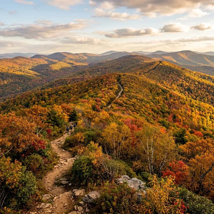
Paxtang Parkway is the Capital Area Greenbelt’s best-kept secret, and the reason most people actually enjoy the Capital Area Greenbelt Harrisburg loop. This segment winds through 80 acres of oak and hemlock forest, with a creek running alongside most of the path. It feels nothing like a city trail. The ground is soft, the canopy is thick, and the only city sounds are those you bring with you.
The segment starts near Wildwood Park and runs north toward the Harrisburg Pike connection. A stream restoration project is currently underway, which means you’ll see evidence of trail work and some temporary reroutes, but the crew is thoughtfully improving drainage and habitat.
When you’re on this section in late spring or early fall, you understand why locals fight so hard to protect this trail.
Watch for: Muddy patches after rain. Bring trail shoes or water-friendly boots. The path can get root-heavy in places.
Watch your footing. Occasional uneven sections require attention, but nothing scrambling-worthy.
Best time: April through November. Avoid January through March when mud is relentless.
Parking: Wildwood Park lot (reliable, larger, free).
Riverfront Park: The Susquehanna Golden Hour Walk
Distance: 3.5 miles one way (7 miles out-and-back) | Surface: Paved | Difficulty: Easy | Crowds: Moderate to high, especially weekends
Riverfront Park is the best section of the Capital Area Greenbelt for scenic views, and the most popular for good reason. This Greenbelt Harrisburg hiking segment offers paved paths and river views.
This paved path runs directly along the Susquehanna River with views of the Harrisburg skyline, the state capitol dome, and the river itself. It’s where the Greenbelt feels less urban and more like a legitimate recreation trail.
The path is wide, well-maintained, and perfect for runners, casual walkers, and cyclists. You’ll see a constant stream of locals here, which means the trail gets maintained and feels safe at almost any hour. The western end reaches the City Island boat launch. The eastern end connects to the Wildwood Park area.
The best time to walk this segment is late afternoon (3-5 PM) when the sun hits the water and the capitol dome glows. Evening walks in summer are legitimately beautiful, bring a camera.
Watch for: Weekend crowding, especially warm-weather Saturdays and Sundays. The paved surface is easy on joints but hard on eardrums if cyclists are speeding. Step to the side and let them pass.
Best time: April through October. Summer mornings (before 9 AM) and weekday afternoons are quieter.
Parking: City Island lot (central, popular, fills on weekends) or Riverfront Park direct access (smaller, less crowded).
Wildwood Park Connection: The Wildlife and Birding Hub
Distance: 2-3 miles, depending on route | Surface: Mix of paved and crushed stone | Difficulty: Easy | Crowds: Low
Wildwood Park is Harrisburg’s genuine nature preserve, 285 acres of forest, meadows, and wetlands on the eastern edge of the city. It’s where serious birders come, and where you’re most likely to see deer, wild turkey, and nesting raptors. The Capital Area Greenbelt Harrisburg route clips through Wildwood and connects it to the broader loop.
If you’re looking for the “nature” part of the Capital Area Greenbelt without the full 20-mile commitment, Wildwood is where to focus your time. The trails here are quieter than the Riverfront segment and more authentically forested than some other sections.
Watch for: The transition from paved to crushed stone can be abrupt. Bring a bike with decent clearance or expect to walk a short section. Also watch for low-hanging branches on the narrower forest paths.
Best time: Spring (April-May) for migrating warblers and nesting activity. Fall (September-October) for hawk migration. Summer for dragonfly activity along wetland edges.
Parking: Wildwood Park lot (reliable, often quiet, good base camp for longer explorations).
The Full 20-Mile Loop Challenge
If you’re thinking about doing the entire Greenbelt in one go, here’s what to expect.
By Foot: 4-6 hours depending on pace and breaks. Most people finish in 5 hours at a casual walking pace (roughly 4 mph with photos and snack stops). Bring water, snacks, and a light jacket even in summer, weather changes fast, and there aren’t many convenience stores on the route.
By Bike: 2-2.5 hours for experienced cyclists. 3-4 hours for casual riders. The route is mostly flat with some gentle rolling sections, so it’s accessible to most fitness levels. A hybrid or road bike works.
Mountain bikes are overkill. Avoid single-speeds on the crushed-stone sections after rain, you’ll regret the choice.
The Hardest Part: Getting across the southern end. The route has to navigate around the state capitol complex and crosses several major roads (Paxton Street, Maclay Street). This 15-20 minute section is unmistakably urban, sidewalks, traffic lights, crossing busy roads.
It’s not dangerous, but it’s visibly different from the forest and river sections. This is where most people decide to do segments instead of the full loop.
Navigation Reality: The CAGA signs are good, but they’re not constant. In the urban sections especially, watch carefully. If you lose the green-and-white signs for more than a minute, you’ve probably taken a wrong turn. Pull out a map or the CAGA website route map on your phone as backup.
Parking & Entry Points
City Island (Central, Most Convenient)
What it is: A 63-acre island in the Susquehanna River with parking, bathrooms, and river views.
Parking: 200+ spaces, free. Fills by mid-morning on summer weekends. Arrive before 9 AM if you want to guarantee a spot.
Why go here: It’s the geographical center of the Greenbelt loop, so you can go either direction. Bathrooms are reliable. There’s a playground and boat launch if you’re with family. The location is excellent for accessing Riverfront Park or starting the full loop.
Tradeoff: Most crowded option. Can feel like a recreation area rather than a trail access point on busy weekends.
Wildwood Park (Eastern, Quieter)
What it is: 285-acre nature preserve with dedicated parking and forest trails.
Parking: 50-80 spaces, free. Rarely fills even on weekends. Generally quieter and more “hiker-feeling” than City Island.
Why go here: If you want the nature-focused segments (Paxtang Parkway, Wildwood itself) without the crowds or urban sections, start here. The lot has better tree cover and feels more like a trailhead than a recreation complex.
Tradeoff: Smaller lot. If you’re planning a longer loop, you’ll face more urban sections if you head toward the southern route.
Reservoir Park (West Side, Historic)
What it is: Historic park with the National Civil War Museum and scenic water views.
Parking: Free lot, moderate size. Usually less crowded than City Island.
Why go here: Good for accessing Fort Hunter to the north or the western sections. The park has historic interest (Civil War earthworks are still visible). Bathrooms and some facilities available.
Tradeoff: The intersection of the Greenbelt with Reservoir Park is confusing, watch for the CAGA signs carefully. Many users report getting lost here.
Wayfinding Tips (Don’t Get Lost at Reservoir Park)
The Greenbelt route is marked with green-and-white signs that say “Capital Area Greenbelt” with an arrow. Here’s the honest truth: they’re good but not constant.
The Reservoir Park Confusion: The route transitions around Reservoir Park in ways that aren’t intuitive. When you reach Reservoir Park coming from the south, look carefully for green CAGA signs before assuming the obvious path is right. Take a moment to check your phone map or the CAGA website route map. Many people wander onto the wrong path here and end up backtracking.
General Wayfinding:
- Always look ahead for the next green-and-white sign.
- In the wooded sections, the path is usually obvious, stay on the main trail.
- In urban sections, watch the sidewalk for sign posts or stenciled green arrows on pavement.
- Download the CAGA route map (available on their website) before you go, or take screenshots.
If You Get Turned Around: Backtrack to the last green sign you saw. Don’t push forward hoping the path reveals itself. The Greenbelt is a known route, so you’re never truly lost, just temporarily misdirected.
Surface Types & What to Wear
The Greenbelt is a mix of surfaces, so choose footwear accordingly.
Paved sections (Riverfront Park, parts of City Island): Smooth, bike-friendly. Road shoes, trail runners, or casual walking shoes work fine.
Crushed stone (Paxtang Parkway, Wildwood connections): Firmer stone, generally well-maintained but can be soft after rain. Trail shoes or hiking boots recommended. Road shoes will work but lack grip.
Dirt and roots (Wildwood, some northern sections): Requires proper traction. Hiking boots or trail runners with aggressive soles. Regular sneakers can slip on wet roots.
Recommendation: If you’re doing the full loop, wear hiking boots or trail runners with good ankle support and grip. You’ll encounter all three surface types, and boots handle the transitions better than shoes optimized for one surface.
Best Time to Visit
Spring (April-May): 60-70°F, lower water levels, green trees beginning to fill in, wildflowers in Wildwood. Best season for getting the full experience without summer crowds.
Summer (June-August): 75-85°F, sometimes humid. Greenbelt is popular, especially on weekends. Early morning walks (before 8 AM) are manageable. Afternoon heat can be intense.
Fall (September-November): 50-70°F, lower humidity, foliage peaks late September through October. Beautiful season but crowded on weekends. Paxtang Parkway is stunning.
Winter (December-March): 25-45°F, mud is relentless on crushed-stone sections, especially Paxtang. The Greenbelt is less popular but muddy and less pleasant than other seasons. Only attempt if you have waterproof boots.
Sweet spot: Late April through May, or September through early October. You get comfortable temperatures, better trail conditions, and fewer crowds than summer weekends.
What to Bring
- Water: At least 2 liters for a full loop. No reliable water sources on the trail itself.
- Snacks: The loop takes 4-6 hours on foot. Pack energy food.
- Sun protection: Sunscreen and a hat. Even shaded sections get sun exposure, and the Riverfront segment is fully exposed.
- Navigation backup: Phone with offline maps or CAGA website route map screenshot.
- Light layer: Even in summer, mornings and evenings can be cool. A windbreaker or fleece is smart.
- First aid: Blister kit, pain relief, and basic bandages. Standard urban/trail precautions.
For biking: Helmet (required by PA law), lights if you’re evening riding, a simple repair kit (tire levers, spare tube, pump).
FAQ: Capital Area Greenbelt Harrisburg
Is the Capital Area Greenbelt Harrisburg a continuous trail? Mostly. About 80% of the Capital Area Greenbelt is dedicated trail (crushed stone, paved, or dirt). The remaining 20% uses urban sidewalks and street crossings with CAGA wayfinding. It’s continuous in the sense that you can complete the loop without getting on a highway, but it’s not wilderness-to-wilderness continuous.
Which part of the Greenbelt Harrisburg is best for running? Riverfront Park on the Capital Area Greenbelt. It’s paved, flat, 3.5 miles one way, and generally well-maintained. Crushed stone at Paxtang Parkway on the Greenbelt works for trail runners but can be uneven.
Can I bring my dog on the Capital Area Greenbelt Harrisburg? Yes. Dogs are allowed on the Capital Area Greenbelt. Keep them leashed in busier sections (Riverfront Park, City Island) and on-trail to protect the restored stream habitat at Paxtang Parkway. Summer heat can be hard on dogs’ paws on paved sections, consider booties for longer walks.
How long does the full Capital Area Greenbelt loop take by bike? 2-2.5 hours for experienced cyclists. 3-4 hours for casual riders. The Capital Area Greenbelt route is mostly flat.
A hybrid or road bike works well. Mountain bikes are unnecessary.
Is there shade on the Capital Area Greenbelt? Yes and no. Paxtang Parkway on the Greenbelt is heavily shaded. Riverfront Park is mostly exposed to sun. City Island and Wildwood have patches of shade.
In summer, early morning or late afternoon walks on the Capital Area Greenbelt are better for heat management. For scenic river views without the full loop commitment, consider other South Central overlooks like Chickies Rock.
Do I need a permit to use the Greenbelt? No. It’s a public multi-use trail system.
Where can I volunteer for trail cleanups? Contact the Capital Area Greenbelt Association (CAGA). They organize regular volunteer days. Visit their website or Facebook page for current schedules.
How to Support the Greenbelt
The Greenbelt exists because locals care about it. CAGA maintains signage, organizes volunteers, and advocates for trail improvements, all on a nonprofit budget.
Pick up trash: If you see litter on the trail, grab a piece or two. It takes a minute and keeps the Greenbelt looking cared-for.
Stay on-trail: The forest and streamside areas are fragile, especially at Paxtang Parkway where restoration is underway. Staying on the marked path protects the habitat.
Volunteer: CAGA hosts volunteer cleanups and trail maintenance days. It’s a great way to meet other locals who love the trail and to see the work that keeps it safe and beautiful.
Spread the word: Honestly recommend the Greenbelt to friends and visiting family. The more people who use it and appreciate it, the more likely the city and county are to fund future upgrades.
Getting There & Logistics
From downtown Harrisburg: City Island is 10 minutes by car (head south on Front Street toward the island). Wildwood Park is 15 minutes northeast (head toward the Harrisburg Pike). Reservoir Park is 5 minutes west (follow Maclay Street west). You’re also within easy reach of other Harrisburg area trails and regional hiking destinations throughout South Central PA.
Public transit: CATA (Harrisburg public transit) has routes to City Island and some Greenbelt access points. Check the CATA website for current schedules.
Nearby amenities: City Island has bathrooms, water fountains, and a small concession stand. Riverfront Park has basic facilities. Wildwood Park has bathrooms. No stores directly on the trail.
The Takeaway
The Capital Area Greenbelt Harrisburg isn’t a wilderness trail, it’s something rarer and, for urban hikers, more valuable. It’s a commitment by an entire city to maintain a walkable, bikeable loop that connects neighborhoods, nature, and recreation into one place.
You can do the Capital Area Greenbelt in segments over a summer, or tackle the full 20 miles on a single ambitious Saturday. Either way, you’re walking a Capital Area Greenbelt Harrisburg trail that locals actually maintain and care about.
Start with Paxtang Parkway or Riverfront Park if you’re new to the Capital Area Greenbelt Harrisburg route. Both showcase why the Capital Area Greenbelt matters. Then, when you’re ready, tackle the full loop.
Watch for the green-and-white CAGA signs, pack water, and give yourself time. The Capital Area Greenbelt rewards patient explorers.
The next time someone tells you Harrisburg is just a city, take them to the Capital Area Greenbelt Harrisburg. They’ll understand why locals fight so hard to keep it beautiful.
Ready to explore the Capital Area Greenbelt? Start with City Island or Wildwood Park parking, both are free, reliable, and give you access to the best Capital Area Greenbelt segments. Download the CAGA route map before you go, bring water and snacks, and plan for 3-5 hours depending on distance and pace on the Capital Area Greenbelt Harrisburg loop.
Related Guides
- Best Hikes Near Harrisburg, PA, Regional trail options in South Central PA
- Other Regional Multi-Use Trail Systems, Comparable Pennsylvania trail networks
- South Central PA Trails and Destinations, More hiking options near Harrisburg and the Capital Area Greenbelt region
Last Updated: April 14, 2026
Questions or trail updates? Contact the Capital Area Greenbelt Association (CAGA) or contact Hiking PA with updates.