Detweiler Park Harrisburg: Hidden Gem Trails with Serious Elevation
411 acres, zero crowds, and a 500-foot climb packed into less than a mile. Detweiler Park is Harrisburg's best-kept secret: same ridge views as Hawk Rock, a fraction of the people.
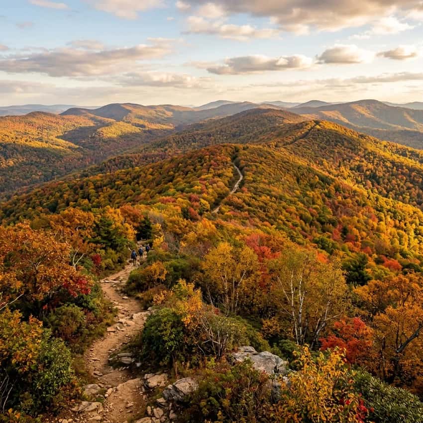
Detweiler Park is a 411-acre local secret in Dauphin County that most Harrisburg-area hikers overlook. The Meade’s Mountain Loop is the park’s signature hike, a strenuous 500-foot climb packed into less than a mile, with panoramic ridge views and zero crowds.
The Airstrip Loop is its perfect counterpart: a 1.4-mile easy walk around a former private airfield, ideal for families or quick sunset strolls. Together, these trails make Detweiler the anti-Hawk Rock: same ridge, same views, fraction of the people. It’s a great alternative to the often-crowded Wildwood Park if you’re seeking true solitude.
Key Takeaways
- Navigation: Use the primary park entrance on Peters Mountain Road (Google Maps | Apple Maps). GPS: 40.3547, -76.9248.
- Hidden Gem: A 411-acre Dauphin County park with 7 miles of quiet forest trails that most Harrisburg hikers overlook.
- Meade’s Mountain Loop: Strenuous (500ft gain, rocky shale terrain) and rewards hikers with panoramic ridge views; zero crowds compared to Hawk Rock.
- Airstrip Loop: Easy (1.4 miles, level) and encircles a former private airfield, offering unique open-sky walking for the region.
- Facilities: This is a primitive park with no restrooms or water; bring your own supply and follow carry-in/carry-out rules.
Why Detweiler Park Is Worth Your Time
Ask fifty Harrisburg hikers where to go, and you’ll hear about Hawk Rock, Cove Mountain, Chickies Rock, the classics. Detweiler Park never comes up. That’s the whole appeal.
This former private family estate turned county park feels like your own discovery. The parking lot fills maybe once a year. The trails are maintained but not polished. You won’t find Instagram crowds at the summit, just ridge views that open up after a hard climb.
If you’re sick of elbowing past twenty other hikers at every vista, Detweiler is your answer. If you want to test your legs on steep shale without the social media circus, come here first.
Getting to Detweiler Park
Parking & Directions: From Harrisburg, take I-81 north toward Duncannon. Exit onto Peters Mountain Road heading north (away from the interstate). Drive approximately 4 miles.
The main park entrance and parking area is on your left. The lot holds about 15 cars and rarely fills, even on weekends.
Address for GPS: Detweiler Park, Peters Mountain Road, Dauphin, PA 17018
Parking Details:
- Small, gravel lot with no facilities
- No water, no restrooms, no kiosks
- Carry-in/carry-out policy (strictly enforced by county)
- Free parking
- Open dawn to dusk
From nearby Harrisburg landmarks:
- From downtown Harrisburg: ~20 minutes
- From Duncannon: ~10 minutes
- From Hawk Rock parking area: ~15 minutes
The drive itself is part of the appeal. Peters Mountain Road winds through quiet farmland and forest, by the time you park, you already feel removed from the city.
The Challenge: Meade’s Mountain Loop (Strenuous)
This is why people come to Detweiler. Meade’s Mountain is one of the fastest elevation gains in the Harrisburg area. You get serious climbing compressed into a short distance.
The Climb Up: From the parking area, head northeast on the marked trail. The first 0.2 miles is gentle, lulling you into a false sense of ease. Then the shale hits. The trail steepens dramatically, and the footing becomes technical.
Loose shale, rocky steps, tight switchbacks. You’re using your hands regularly here. It’s not a scramble, you’re not rock climbing, but you’re definitely engaging your upper body and balance.
The steep section lasts about 0.8 miles. Every step up is a step you’ll feel on the way down. Your thighs will know they worked.
Why the Difficulty: Meade’s Mountain earns its “Most Difficult” rating for three reasons:
- Elevation speed: 500 feet of gain in less than a mile means constant uphill
- Shale terrain: Loose rock that shifts underfoot, especially hazardous after rain or on descent
- No relief: Unlike some trails with a short flat section to catch breath, this is relentless climbing
The Ridge Top: At the summit, the payoff hits immediately. You emerge onto a cleared ridge with panoramic views. David’s Field spreads out below you, a wide meadow that contrasts sharply with the forested ridgeline. On clear days, you can see Clark’s Valley to the northeast and the rolling Appalachian landscape stretching in multiple directions.
Hikers regularly report this as one of the best-kept-secret ridge views in South Central Pennsylvania. Hawk Rock gets the fame. Meade’s Mountain gets the actual solitude.
The Descent: Coming down the shale is trickier than going up. If the ground is wet, it’s genuinely slippery. Plant your feet deliberately and take your time. Many hikers report that the descent is harder than the ascent, not in elevation, but in technical footing.
Bring trekking poles if you have them. They save your knees on steep descents and add stability on loose rock.
Season Note: Spring (March through May) is muddy on this trail. The shale absorbs water and becomes more slippery. Fall is ideal, dry shale, cooler climbing, and clear ridge views.
The Scenic Path: Airstrip Loop & David’s Field
Not every day is a climbing day. That’s where the Airstrip Loop shines.
What You’ll See: This 1.4-mile loop circles what used to be a private airfield. The open clearing is now maintained as a meadow, giving Detweiler a rare feature: open sky. You get unobstructed sunset views, easier photography, and a completely different hiking experience than the forested ridges that dominate the area.
The trail itself is mostly level with minimal elevation change. It’s wide, well-marked, and suitable for families with children or anyone wanting an easy walk.
The History: The airstrip dates back decades as a private landing area. Now it’s just a meadow, but the cleared area creates a visual break that makes for distinctive photography and genuine uniqueness among local trails.
Why It Matters: Many South Central PA trails are forest hikes with occasional views. Detweiler offers both: deep forest solitude on the ridge, and open-sky walking on the airstrip. Most hikers do one or the other. Consider combining them for a 4-5 mile loop that touches both experiences.
Trail Conditions & What to Expect
Terrain Type: Shale and loose rock on the ridge, hard-packed dirt and meadow grass on the airstrip loop. Neither section is muddy under normal conditions, but shale becomes slippery when wet.
Water Sources: None. Bring all the water you need. The park doesn’t have reliable water sources on trail.
Trail Marking: Good blazing on main trails, occasional faded markers deeper into the park. Stick to the main Meade’s Mountain and Airstrip loops if you’re new here, the system is intuitive but not heavily signed.
Crowds & Atmosphere: Quiet is the defining feature. Weekends see maybe a handful of hikers. Weekday visits are often solo. This is genuinely different from Hawk Rock or the popular Harrisburg-area parks.
Time Estimate:
- Meade’s Mountain Loop alone: 1.5-2 hours (depending on fitness and rest time at the summit)
- Airstrip Loop alone: 30-45 minutes
- Combined loop: 2.5-3.5 hours
Need to Know Before You Go
Tick Warning: This is Peters Mountain, prime tick habitat. Late spring through fall, ticks are active here. Wear light-colored pants so you can spot them, tuck pants into socks, and do a full-body check when you finish.
The shale and rocky terrain don’t reduce tick pressure. If anything, the dense brush makes it worse.
Shale Safety: After rain, the steep shale section becomes genuinely slippery. Many hikers skip Meade’s Mountain the day after rain and opt for the Airstrip Loop instead. Your knees will thank you for being cautious on descent.
Carry-In/Carry-Out: Dauphin County strictly enforces this policy. Pack out everything you pack in, including toilet paper if you need a backcountry bathroom. Respect this, trail access depends on it.
No Facilities: There are zero facilities at the park. No water, no restrooms, no concessions. Bring a full water supply and use the restroom before you arrive.
Hunting Season: Detweiler Park allows hunting during Pennsylvania’s season (October-January, with specific dates for rifles/shotguns). Wear blaze orange if you hike here in fall or early winter. The park doesn’t see heavy hunting pressure, but it’s required.
Permit or Pass: None required. The park is free and open to the public. Dauphin County maintains it as a public recreation area.
Best Season & Why
Fall (September-October): Ideal. Cool temperatures make the Meade’s Mountain climb more manageable. The ridge foliage is golden.
The shale is dry. Crowds remain minimal.
Spring (March-May): Variable. Mud on trails and slippery shale from winter runoff make this less ideal for the steep climb, but the Airstrip Loop is lovely as wildflowers emerge.
Summer (June-August): Hot and humid, the ridge climb becomes genuinely uncomfortable. Early mornings help. The open Airstrip Loop is cooler than the forested ridge.
Winter (November-February): The shale becomes icy. Some hikers with microspikes tackle it successfully. Others skip the ridge hike entirely in winter and enjoy the Airstrip Loop for a quieter, colder experience.
Photography Tips: Capturing Detweiler Park
Meade’s Mountain Ridge Views: Shoot from the summit overlook during late afternoon when the sun is lower and shadows define the terrain. Wide-angle lenses (16-35mm) capture the panoramic ridge sweep. The meadow (David’s Field) below creates a compositional break between foreground rocks and distant ridges.
Shale Terrain Detail: The loose, fragmented shale creates unique texture photography. Macro shots of individual shale pieces show geological interest. Golden hour light raking across the rocky terrain emphasizes texture and creates shadows that add dimension.
Fall Foliage Composition: Mid-October, frame the golden/red valley hillsides with the cleared meadow in the middle ground and the ridge edge in the foreground. The color contrast between the hardwood colors below and the darker ridge makes compelling landscape shots.
The Airstrip Meadow at Sunset: The open Airstrip Loop offers unobstructed sunset views, rare in forested South Central PA. Position yourself in the meadow with wildflowers (spring) or golden grass (fall) in the foreground, the cleared airstrip runway visible as compositional lines, and sunset sky beyond.
Wildlife and Wildlife Tracks: The meadow attracts deer, especially at dawn and dusk. The shale terrain shows clear animal tracks. These add narrative interest to landscape photography:tell the story of the place through evidence of wildlife.
Avoid Midday Harsh Light: Summit ridge shooting at noon creates flat, washed-out colors. Early morning (before 10 a.m.) or late afternoon (after 3 p.m.) provide directional light that defines shape and shadow.
Why Detweiler Over Other Local Options
vs. Hawk Rock (nearby on Peters Mountain): Hawk Rock is more famous, more crowded, and more of a destination. Detweiler offers the same ridge proximity with 90% fewer people. The views are comparable. The crowds aren’t.
vs. Chickies Rock (near Columbia): Chickies Rock is higher and more dramatic. Detweiler is quieter and more technical. If you want a training climb with no onlookers, Detweiler wins.
vs. Cove Mountain (east of Harrisburg): Cove Mountain is easier and offers similar ridge views. Detweiler is steeper and more challenging. Pick based on your goals: scenic walk or training climb.
The Real Advantage: Detweiler isn’t better, it’s just different. It’s the local’s choice because locals like solitude. If you’ve done the famous trails and want to experience South Central PA hiking without the crowds, this is it.
How to Combine Detweiler with Nearby Trails
The Peters Mountain Ridge Experience: Detweiler Park sits on Peters Mountain Ridge, which stretches for miles. Duncannon’s Hawk Rock is just a few miles away on the same ridge. Some hikers do a car shuttle and hike the ridge between them (advanced navigation required).
The South Central PA Circuit: Pair Detweiler with Chickies Rock, Governor Dick, or Stony Valley Ruins for a weekend of South Central hikes. Each offers a different experience and different difficulty levels.
Your Next Trip: If Detweiler’s steep shale climb appeals to you, explore the complete South Central PA trail guide. The region has everything from easy creek walks to technical backcountry routes.
FAQ: Detweiler Park
How hard is Meade’s Mountain at Detweiler Park? It’s strenuous, 500 feet of elevation gain in less than a mile, on loose shale terrain. Not technical scrambling, but you’re using your hands, watching footing carefully, and feeling every step on descent. Intermediate fitness required.
Are there easy trails at Detweiler Park? Yes. The Airstrip Loop is 1.4 miles, mostly level, and perfect for families or quick walks. It’s the park’s accessible option.
Is Detweiler Park crowded? Rarely. Even on weekends, you might see a handful of hikers. The park simply isn’t on most people’s radar. That’s the appeal.
When is the best time to visit Detweiler Park? Fall (September-October) is ideal. Cool temps, dry shale, minimal crowds. Spring is muddy.
Summer is hot. Winter shale is icy.
Can I bring dogs to Detweiler Park? Dogs are permitted on-leash. The shale on Meade’s Mountain is rough on dog paws without protection. Consider dog boots for the steep section.
Is there water or restrooms at Detweiler Park? No. No facilities at all. Bring a full water supply and use facilities in town before arriving.
What to Bring
Essentials:
- Water (at least 2 liters, no refill source)
- Trekking poles (especially for descent on shale)
- Sun protection (hat, sunscreen)
- A small backpack for layers
For Meade’s Mountain Specifically:
- Extra water (the climb is relentless)
- Snack or lunch for summit
- Trekking poles (seriously, descent on shale beats up knees)
- Microspikes if visiting October-February
For Airstrip Loop:
- Water
- Camera (the meadow is photogenic, especially at sunset)
- Lighter pack is fine, it’s a relaxed walk
For All Seasons:
- Tick check kit (inspection, tweezers)
- Blaze orange (October-January)
The Final Word
Detweiler Park is a training climb with a secret. The elevation gain is real, the shale is technical, and the views are genuinely worth the effort. But what makes it special is the silence. No crowds.
No drama. Just you, steep shale, and a ridge view that most people never discover.
If you’re a Harrisburg hiker who’s done the circuit and wants to go deeper into your local mountains, Detweiler is the next step. If you’re visiting the region and want solitude instead of Instagram views, start here.
The airstrip meadow is perfect for slow evening walks. The ridge is built for serious hikers. Detweiler works for both, which is why locals keep it to themselves.
Ready to explore South Central PA’s quietest ridge hike? Start with Meade’s Mountain Loop, eat lunch at the summit, and discover why Detweiler Park is the secret spot locals don’t share.