Falls Trail at Ricketts Glen: The Complete Hiker's Guide
Counter-clockwise route, 21 named waterfalls, and the 3.2-mile shortcut. How to hike Pennsylvania's best waterfall trail without ending up in a rescue story.
The Falls Trail at Ricketts Glen passes 21 named waterfalls. The tallest drops 94 feet. Pennsylvania’s state park system rates it “Most Difficult” for a reason.
The park sees up to 30 rescues every year. This is one of the best hikes in the state. But do not walk into it without knowing what you are dealing with.
Key Takeaways
- Navigation: Use the Lake Rose Trailhead off Route 487 (Google Maps | Apple Maps). This provides the most direct access to the cascades. GPS: 41.3344, -76.2891.
- Distance & Route: Choose between the full 7.2-mile loop or the 3.2-mile shortcut. Always hike counter-clockwise for safer descents.
- Safety Footwear: Proper lugged boots are mandatory. The gorge trail is permanently wet and slips are frequent.
- Winter Closure: This trail is strictly closed from December through late March. Ice accumulation on rock stairs makes it lethal.
Ricketts Glen is a National Natural Landmark. It is home to the most concentrated waterfall hike in the eastern United States. The falls are world-class.
The trail is also genuinely dangerous. Perpetually wet rocks and steep drops lead to frequent rescues. This is a physical reality, not an exaggeration. Treat the safety section with the same focus you give the photography section.
Which Direction to Hike
Counter-Clockwise (The Right Call)
- Start: Lake Rose Trailhead
- Route: Down Glen Leigh → Waters Meet → Up Ganoga Glen → Highland Trail back to Lake Rose
Why it works: You see Mohawk Falls within ten minutes of leaving the car. Descending Glen Leigh is easier on the knees than climbing it. Glen Leigh is the steeper of the two gorge sections.
You encounter the most technical terrain when your legs are fresh. The flat Highland Trail at the end gives tired legs a recovery mile before the finish.
Counter-clockwise also means you move in the same direction as most other hikers. At Waters Meet, where the two gorge branches converge, the bottleneck is more manageable when everyone flows the same way.
Steel staircases make the descent manageable, not easy. The rocks above and below them are wet.
Clockwise (The Contrarian Route)
You get the flat Highland Trail done first, then climb the steeper sections on tired legs. The only legitimate reason to go clockwise is if you are starting from the Ganoga Glen trailhead rather than Lake Rose. From Lake Rose, counter-clockwise is the correct choice.
The Waterfalls
The 21 Named Falls: Counter-Clockwise Order
Glen Leigh (descending): Mohawk, Oneida, Cayuga, Ganoga, Seneca, Delaware, Mohican, Conestoga, Tuscarora, Erie
Waters Meet (junction)
Ganoga Glen (ascending): Harrison Wright, Sheldon Reynolds, Murray Reynolds
The remaining falls are distributed through the loop including Ozone, B. Reynolds, Huron, F. Murray, and others. The counter-clockwise route ensures you hit all 21.
The Photography Targets
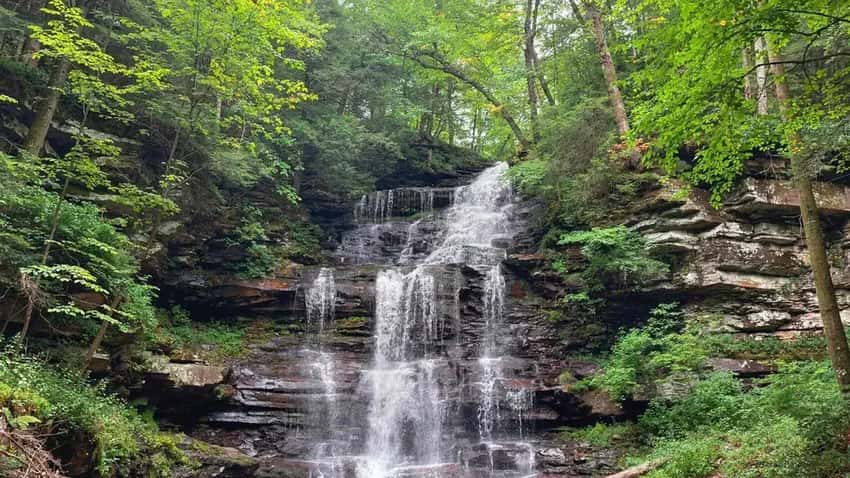
Ganoga Falls (94 feet) is the tallest waterfall in Pennsylvania. It is a straight plunge. You will need a wide-angle lens from the base to capture the full height of the drop.
Plan to spend time here. The viewing area is open, but hikers move through constantly on weekends.
Harrison Wright Falls has a photogenic structure. It gets crowded because of its accessibility. Arrive early for a clean shot or accept that people will be in your frame.
Sheldon Reynolds Falls is perfect for long-exposure water blur. The shape of the fall and the surrounding rock lend themselves to half-second to two-second exposures.
Oneida Falls (13 feet) is small but consistently produces the best angles. The pool at the base and the intimate approach make it a favorite for many photographers.
Ganoga Falls. At 94 feet, it is Pennsylvania’s tallest. Shoot from the base with a wide-angle lens.
Photography Guide
The Falls Trail is one of the most photographed places in the state. You will share space with other hikers at every popular spot.
Light conditions: Overcast is better than sun. This is true without exception for this trail. The gorge is narrow. Direct sunlight creates harsh highlights and deep shadows that ruin a frame.
An overcast day produces even, soft light. It handles the contrast between white water and dark rock. It is worth delaying a trip for an overcast forecast.
Camera settings for moving water:
- Silky blur: 0.5 to 2-second shutter speeds
- Frozen detail: 1/100s or faster
- ISO: 100 to 200 to minimize noise
- Aperture: f/8 to f/11 for depth
Gear that earns its weight here:
- Tripod (mandatory): You cannot hand-hold the shutter speeds needed for smooth water. This is not optional.
- Circular polarizer (CPL): Cuts glare off wet rock faces and foliage. Colors shift noticeably with one on.
- ND filter: Useful for achieving blur in brighter conditions when the CPL alone is not enough.
- Wide-angle lens (16-35mm range): The gorge sections are tight. You need a wide view to capture the scale of the larger falls.
- Microfiber cloth: The spray from several falls reaches camera gear. Ganoga Falls in particular.
Crowd management: The junction at Waters Meet gets packed in October. You must be patient if you want clean shots.
The window for uncrowded photography at the junction is before 9 AM on weekends. Weekdays are always better than weekends during any season.
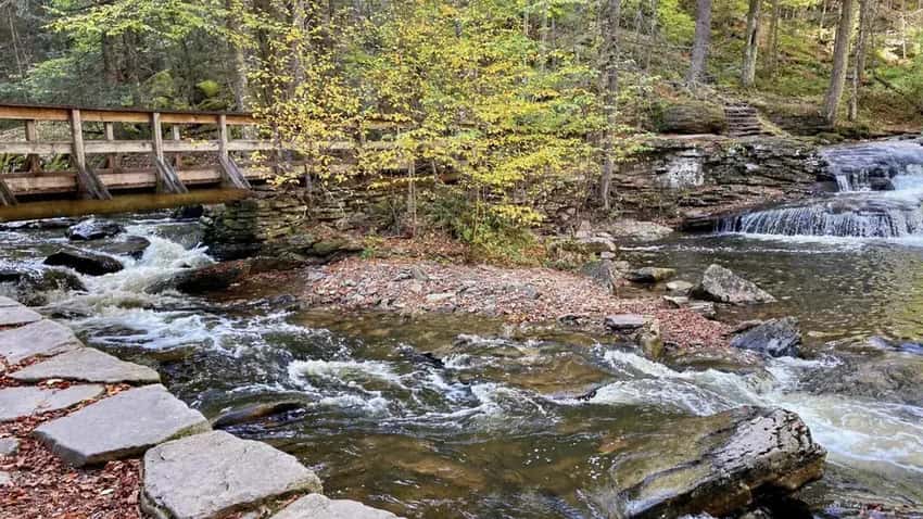
Waters Meet junction. Photographers need a tripod and patience here on busy weekends.
The 3.2-Mile Shortcut (18 Waterfalls)
Route: Lake Rose → Down Ganoga Glen → Waters Meet → Up Glen Leigh (partial) → cut across Highland Trail back to Lake Rose.
You miss three of the smaller named falls. You still see Ganoga, Harrison Wright, and Sheldon Reynolds. The trade is two miles of trail and roughly 90 minutes of hiking time.
Right for: Families with older kids who can handle challenging terrain. Photographers who want to maximize time at specific falls rather than covering all 21. Hikers who are uncertain about the full loop.
Not for: Anyone specifically trying to hike all 21. That requires the full 7.2-mile loop.
Safety
The park records up to 30 rescues every year on this trail. Most incidents involve slips on wet rock.
Some involve people who went off-trail for a better photo angle. Others involve inadequate footwear on the descents.
Footwear. Use hiking boots with ankle support and a lugged rubber sole. Do not wear trail runners or sneakers. Sandals are dangerous here.
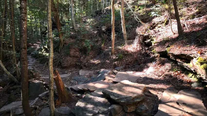
The rocks are permanently wet from spray. They are often covered in moss and algae. A lugged sole provides grip on wet stone. A flat-sole shoe does not.
The wet rock problem. Every stone surface on this trail is wet. This includes stairs, flat ledges, and the trail tread.
The spray radius from the larger falls reaches 20 feet or more. There is no dry section.
Step deliberately and test surfaces before committing your weight. Use the installed steel handrails where they exist.
Ticks. The wooded ridge sections above the gorge and the brushy Highland Trail return have tick activity. Check thoroughly after the hike.
The Highland Trail return runs through exactly the kind of brushy cover ticks favor. Long socks pulled over your pants help.
Winter closure. The Falls Trail closes every year from December through late March or early April. Ice on the rocks and stairs is lethal.
The closure is enforced. Do not attempt the trail in winter unless you are a registered ice climber with proper gear.
Crowds and passing. The trail is narrow in the gorge. Passing a group on a steep section requires coordination.
Counter-clockwise travel reduces the frequency of head-on passing. Be patient at bottlenecks.
Parking and Logistics
Lake Rose Trailhead is the standard starting point. The lot fills before 8 AM on October weekends. If you arrive late, you will be parking on the road or in overflow areas. Arrive early to avoid the extra walk.
Ganoga Glen Trailhead is less used and rarely fills. It adds a different approach to the loop. Check park maps for the current availability.
Restrooms and facilities are available near the main campground. There are no water sources on the trail itself. Bring everything you need before you start.
Seasonal Conditions
Spring (April through May): Falls are at their highest volume from snowmelt. The trail is wet and occasionally muddy. Ticks activate in May. This isarguably the best season for the falls themselves.
Summer (June through August): All 21 falls are running but some are noticeably lower. The trail is in full leaf and the gorge is shaded. The trail is crowded on weekends.
Fall (September through October): Peak color usually happens in the second week of October. The gorge in fall color is worth the crowd. Arrive before 8 AM or visit during the week. Water volume recovers with fall rain.
Winter: Closed. End of discussion.
FAQ
Which direction should I hike? Counter-clockwise from Lake Rose. You see Mohawk Falls within ten minutes, descend the harder Glen Leigh section on fresh legs, and finish on the flat Highland Trail.
How long does it take? 4 to 6 hours for the full loop. Add 1 to 2 hours if you are photographing seriously.
What is the best waterfall for photos? Ganoga Falls (94 feet) for scale. Oneida Falls (13 feet) for angles and intimacy. Sheldon Reynolds Falls for long-exposure water motion.
Is there a shorter option? Yes. The 3.2-mile loop hits 18 of the 21 named falls and cuts roughly 90 minutes off the full loop.
What footwear do I need? Hiking boots with ankle support and lugged soles. The rocks are wet permanently. Sneakers and trail runners are consistently involved in the rescue incidents.
When is the trail closed? December through late March or early April. The closure is enforced. Ice on wet rock stairs is not a trail you can manage carefully. It is simply closed.
The Falls Trail is the best hike in Pennsylvania. For everything else Ricketts Glen offers, including the lake and camping, the park guide covers the full picture.
The Poconos region guide covers what else is worth doing in the area. It is perfect for building a full weekend around your visit.