Laurel Highlands Hiking Trail: Shelters, Mileage & Planning Guide
A 70-mile point-to-point trail from Ohiopyle to Seward with eight shelter areas. Here's the mileage, how reservations work, and what to plan before you go.
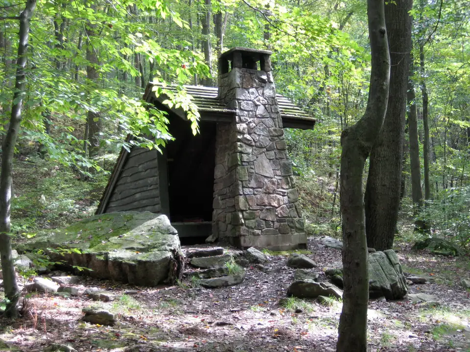
Photo: Ron Shawley / Wikimedia Commons, CC BY 3.0, resized. A temporary photo until we add our own.

The Laurel Highlands Hiking Trail runs 70 miles along Laurel Mountain, from Ohiopyle State Park in the south to the Seward trailhead near Johnstown. It is the main feature of Laurel Ridge State Park, and DCNR rates it most difficult, with severe elevation gain and loss.
You can backpack it over several days using reserved shelter areas, or hike it in sections between trailheads. Either way, it is one way, so plan your shuttle first.
This guide uses DCNR’s Laurel Ridge pages, checked November 14, 2026. Conditions change, so check with the park before you go.
Trail at a glance
- Length: 70 miles, point to point
- Ends: Ohiopyle trailhead (mile 0) and Seward trailhead on PA 56 (mile 70)
- Rating: Most difficult, per DCNR
- Blazes: Yellow on the main trail, about every 100 feet. Blue blazes mark connector trails to parking and shelter areas.
- Mile markers: A mileage monument every mile
- Open: Year round
- Not allowed: Horses, bicycles and motorized vehicles
DCNR suggests planning on about 1.5 miles per hour. At that pace, the full 70 miles is roughly 47 hours of walking, before breaks.
Trailheads and shelter areas
There are six trailheads with parking for about 30 cars each, plus daily parking at Maple Summit Road. Eight shelter areas sit about every six to 12 miles. DCNR lists them by trail mile:
| Mile | Facility |
|---|---|
| 0 | Ohiopyle Trailhead |
| 6.3 | Ohiopyle Shelter Area |
| 11.2 | Maple Summit Road daily parking |
| 18.5 | PA 653 Shelter Area |
| 18.8 | PA 653 Trailhead |
| 24 | Grindle Ridge Shelter Area |
| 30.6 | PA 31 Trailhead |
| 32.5 | PA 31 Shelter Area |
| 38.2 | PA Turnpike Shelter Area |
| 45.8 | US 30 Trailhead |
| 46.5 | US 30 Shelter Area |
| 56.9 | PA 271 Trailhead and Shelter Area |
| 64.9 | PA 56 Decker Avenue Shelter Area |
| 70 | PA 56 Seward Trailhead |
DCNR lists no trailhead amenities beyond parking and trash receptacles. Each shelter area has five Adirondack-type shelters with fireplaces, two vault toilets and space for 25 tents.
Elevation
The Keystone Trails Association says the trail tops out above 2,700 feet, and some sections drop about 1,000 feet to valley floors. The park offers a trail brochure with a map and elevation chart, so pick one up or download it before you go.
Planning a full hike
Using every shelter area, the full trail breaks into nine legs. These distances come from DCNR’s trail miles above. Connector trails between the main trail and shelter areas add a little to each day.
| Leg | From | To | Trail miles |
|---|---|---|---|
| 1 | Ohiopyle Trailhead | Ohiopyle Shelter Area | 6.3 |
| 2 | Ohiopyle Shelter Area | PA 653 Shelter Area | 12.2 |
| 3 | PA 653 Shelter Area | Grindle Ridge Shelter Area | 5.5 |
| 4 | Grindle Ridge | PA 31 Shelter Area | 8.5 |
| 5 | PA 31 | PA Turnpike Shelter Area | 5.7 |
| 6 | PA Turnpike | US 30 Shelter Area | 8.3 |
| 7 | US 30 | PA 271 Shelter Area | 10.4 |
| 8 | PA 271 | Decker Avenue Shelter Area | 8.0 |
| 9 | Decker Avenue | Seward Trailhead | 5.1 |
That’s eight nights if you stop at every shelter area. You can combine short legs, such as 3 and 4 or 5 and 6, to finish in fewer days. Remember you can stay only one night per area, and every night needs a reservation.
The Laurel Highlands visitors bureau calls the first 6.5 miles from Ohiopyle strenuous, with significant elevation change. It says the northern end, from PA 271 to Seward, has fewer elevation changes.
Shorter trips and highlights
The visitors bureau suggests these for a first trip:
- Beginner day hike: PA 653 to Middle Fork Vista
- Beginner overnights: PA 653 to Grindle Ridge, or PA 31 to the Turnpike shelters
It also lists these highlights by mile marker:
- Victoria Flats Vista: just after mile 2
- Middle Fork Vista: mile 21.4
- Rock City: between miles 22 and 23
- Beam Rocks: mile 40
It notes there are no significant waterfalls on the trail. In spring, look for wildflowers, mountain laurel and rhododendron, and in fall the vistas are good for foliage.
Overnight reservations
Reservations are mandatory for every overnight stay. You can book up to 11 months ahead, online through PA state parks or by calling the park at 724-455-3744.
- Fee: Charged per person, per night, and paid when you book. Check the current amount when you reserve.
- One night per area: You can stay only one night at each shelter area.
- Group limits: A group can use up to three shelters per stop, and each shelter holds five people. Extra members can camp next to the shelters.
- Supervision: One adult 18 or older is required for every 10 campers.
- Camping: Allowed only in shelter areas.
When you book, have the group leader’s details, an emergency contact, your dates, the shelter areas, your entry point and a description of any vehicles you’ll leave at the trailhead.
Water
DCNR says non-potable water is available at most trailheads and shelter areas. Treat or filter all of it, and carry enough for the stretches in between.
The visitors bureau lists potable water at three spots: mile 26 just south of Seven Springs, the Laurel Ridge maintenance area along PA 653, and the PA 653 trailhead parking lot. DCNR’s page doesn’t confirm these, so ask the park office before relying on them.
Shuttles
Because the trail is one way, you’ll need two cars or a shuttle. DCNR lists Wilderness Voyageurs in Ohiopyle and Coal Tubin’ in Johnstown as shuttle services. Contact them directly for current availability and prices.
Safety
- Register: Day hikers are encouraged to fill out a card at the trailhead registration box. It helps rangers in an emergency.
- Medical help can be hours away: DCNR warns of this, so carry a first aid kit and tell someone your plan.
- Hunting seasons: Wear fluorescent orange in hunting areas.
- Pack for weather: DCNR recommends layers, rain gear, extra clothing, insect repellent, sunscreen and poison ivy protection.
- Fires: Allowed only in camp stoves, the shelter fireplaces or designated spots, and they must be out when you leave them.
- GPS coordinates are posted on the bulletin board at each trailhead.
Winter
The trail stays open year round, and the park is open for snowshoeing. There are also 20 miles of cross-country ski trails next to the PA 653 parking area. Ask the park office which sections of the main trail suit skiing.
Contact
Laurel Ridge State Park, 1117 Jim Mountain Road, Rockwood, PA 15557. Phone 724-455-3744, email laurelridgesp@pa.gov.
More in the area
The southern end starts in Ohiopyle State Park. For more hikes nearby, see our Laurel Highlands guide, including Linn Run State Park.