Mount Davis: Visiting Pennsylvania's Highest Point (3,213 Feet)
Mount Davis in Forbes State Forest is Pennsylvania's highest point at 3,213 feet. You can drive almost to the top, climb the observation tower, or hike the High Point Trail from the picnic area.
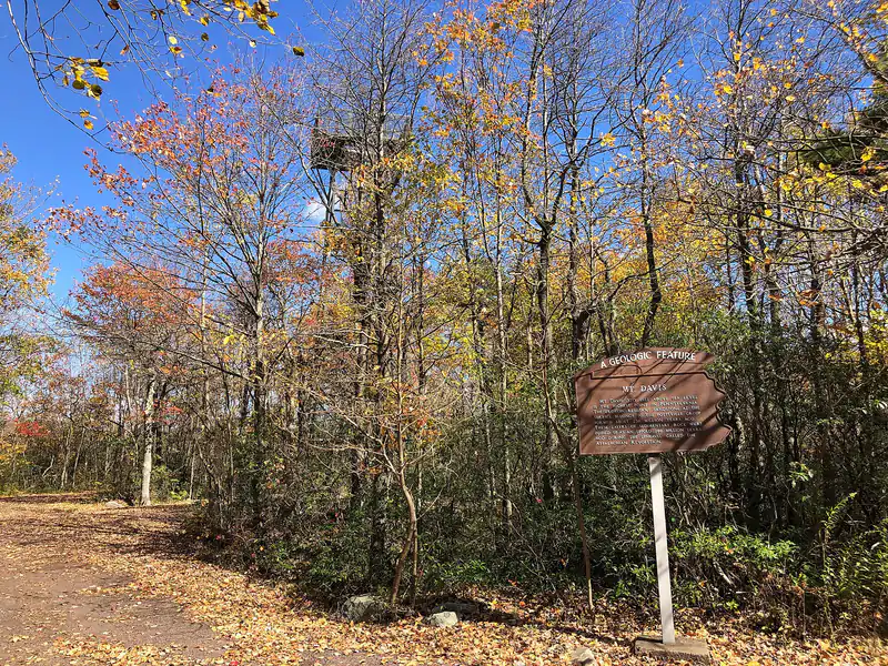
Photo: Famartin / Wikimedia Commons, CC BY-SA 4.0, resized. A temporary photo until we add our own.

Mount Davis is the highest point in Pennsylvania, at 3,213 feet. It sits in the Mount Davis Natural Area, a 581-acre part of Forbes State Forest in southern Somerset County, near Salisbury and Meyersdale. Don’t expect a peak: the summit is a broad, forested high plateau. A road goes nearly to the top, and an observation tower gets you above the trees for a 360-degree view.
Key Takeaways
- Elevation: 3,213 feet, the highest point in Pennsylvania (DCNR)
- Getting there: a paved road leads almost to the summit, with a very short walk the rest of the way (Google Maps | Apple Maps)
- The view: from the observation tower; the ground-level high point is wooded
- To hike it: trails connect the Mt. Davis Picnic Area, about a mile away on Mt. Davis Road, with the high point
- Cost: no fee or permit to visit or hike
Getting There
From Salisbury, follow Route 669 and the signs for Mount Davis to Mt. Davis Road. The road to the high point is the only place motor vehicles are allowed in the natural area. In 2026 DCNR resurfaced the entrance road and the parking lots near South Wolf Rock Road and Mount Davis Road, and added accessible parking spaces and a bus turnaround.
Out-of-state license plates are common in the lot. Many visitors are “highpointers” working through the highest points of all 50 states.
The Observation Tower
The ground-level high point is surrounded by trees, so the view is from the metal observation tower beside it. The tower has interpretive signs and a relief map, and on a clear day you can see in all directions over the Allegheny Plateau.
DCNR refurbished the tower in 2026, the first major work on it in years. Crews took down part of the steel structure, removed corrosion, repainted it, and reinstalled the platforms and stairs. The same project replaced more than 30 interpretive displays and signs and added an information kiosk.
The tower is climbed by stairs. It is not wheelchair accessible.
Hiking at Mount Davis
You can drive to the top, but walking in from the picnic area is the more satisfying way to arrive.
High Point Trail
The yellow-blazed High Point Trail, built by the Civilian Conservation Corps in the 1930s, links the Mt. Davis Picnic Area with the summit. Highpoint.guide describes it as roughly 0.8 mile each way with little climbing. It’s an easy walk through the plateau forest.
Longer Walks
More trails in the natural area drop to lower elevations, including the Tub Mill Run and Laurel Run Trails, which you can combine with the High Point Trail. Get the Forbes State Forest map before you go; it shows the full trail network.
What Makes It Interesting
- Frost-heave stone rings. DCNR notes small, concentric rings of stone on the plateau, formed by localized frost heaving.
- Harsh weather. Temperatures here have ranged from -30°F to 95°F, frost has been recorded in every month, and snow can be 4 feet deep by midwinter (DCNR). Trees show wind deformation and ice-storm damage.
- Water heading west. The area drains into Tub Mill Run and then the Casselman River, which is part of the Mississippi River watershed.
- The name. Mount Davis is named for John Nelson Davis, a local settler, Civil War veteran, surveyor and naturalist. In 1921 the USGS confirmed it as the state’s highest point, replacing Blue Knob.
Rules and Camping
- No fee or permit is needed to visit or hike.
- No camping in the natural area. Backpack camping is allowed in much of Forbes State Forest outside it, and car camping requires a permit at designated sites. Check Forbes State Forest rules before you plan an overnight.
- Vehicles stay on the road to the high point.
- Winter: the trails are open year-round, but snow and ice can make access difficult. Check with the Forbes State Forest office before a winter trip.
Pair It With
Mount Davis is in the Laurel Highlands, so it combines well with a day at Ohiopyle or a section of the Laurel Highlands Hiking Trail. DCNR’s sightseeing page also lists the High Point Overlook in Forbes State Forest, which is ADA accessible and looks over High Point Lake.
FAQ
What is the highest point in Pennsylvania? Mount Davis, at 3,213 feet, in Forbes State Forest in Somerset County.
Can you drive to the top of Mount Davis? Almost. A paved road leads nearly to the summit, and a very short walk finishes it.
Is there a view from Mount Davis? From the observation tower, yes: 360 degrees on a clear day. The ground-level high point is in the trees.
Is there a hike to Mount Davis? Yes. The High Point Trail links the Mt. Davis Picnic Area with the summit, roughly 0.8 mile each way, and longer trails drop into the natural area.
Does it cost anything to visit? No. There’s no fee or permit to visit or hike.
Who is Mount Davis named after? John Nelson Davis, a local settler, Civil War veteran, surveyor and naturalist.