PA Grand Canyon Hiking Guide: Trails, Overlooks & Planning Tips
Leonard Harrison or Colton Point? The Rail Trail or the West Rim? Here's your complete guide to hiking the PA Grand Canyon without the crowds - including shuttle info, fall colors timing, and the best trails.
Key Takeaways
- Colton Point vs. Leonard Harrison: Leonard Harrison (East Rim) is the “Discovery Channel” side with paved overlooks and crowds. Colton Point (West Rim) is the “National Geographic” side: rugged, rustic, and the only place to catch a proper sunset over the gorge.
- Barbour Rock Secret: For the best effort-to-reward ratio, hike the Barbour Rock Trail. It is nearly flat and ADA-accessible, but delivers a massive vista that rivals the most famous overlooks in the park with 90% fewer people.
- Rail Trail Direction Hack: If you’re biking the Pine Creek Rail Trail through the canyon, ride North to South (Ansonia to Blackwell). The grade is a very subtle downhill, making the 16-mile journey through the heart of the gorge significantly easier.
- Turkey Path Reality: This trail often closes from late November through April due to dangerous ice buildup on the stairs. Always check the DCNR website before making the trip specifically for this descent.
- “Rattlesnake Row”: The sunny, rocky outcroppings along the West Rim Trail are prime timber rattlesnake habitat. Stay strictly on the blazed path; snakes choose the quiet, off-trail rocks and will generally avoid the vibrating footsteps on the main trail.
If you have only ever hiked the foothills of Pennsylvania, the PA Grand Canyon will recalibrate your expectations. A National Natural Landmark since 1968, the canyon is 47 miles long and nearly 1,500 feet deep, carved by Pine Creek through millions of years of limestone.
Why Hike the PA Grand Canyon?
Most visitors stand on the rim at Leonard Harrison State Park with hundreds of others to get the classic postcard shot. But the real soul of the canyon is found in the descent. Whether you take the 800-foot plunge down the Turkey Path or bike the 16-mile wilderness corridor on the gorge floor, the experience changes entirely once you lose cell service and hear only the rush of Pine Creek.
This is the premier “big sky” destination in the state, offering 30 miles of rugged backpacking on the West Rim Trail and over 60 miles of smooth, high-speed cycling on the Rail Trail. Regardless of your fitness level, the canyon offers a scale of scenery that is unmatched in the Northeast.
The PA Grand Canyon - a National Natural Landmark since 1968
The Eternal Debate: Leonard Harrison vs. Colton Point
The canyon is split by Pine Creek. You can drive between the two state parks in about 30 minutes, or stare at one from the other.
Leonard Harrison State Park (East Rim)
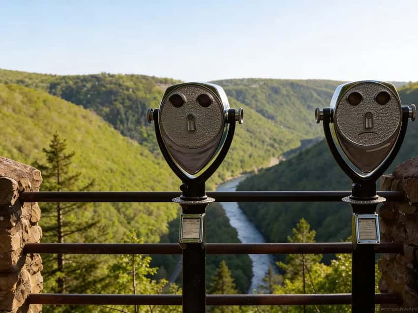
This is the postcard view. It has paved overlooks and a modern visitor center. It is the place for the iconic “standing on the edge of the canyon” photo.
The park is crowded for a reason. The views are spectacular and easy to reach. The famous Turkey Path descends 800 feet to the gorge floor from here.
Expect steep switchbacks and waterfalls on Little Fourmile Run. Visit Leonard Harrison if you want amenities and the classic vista.
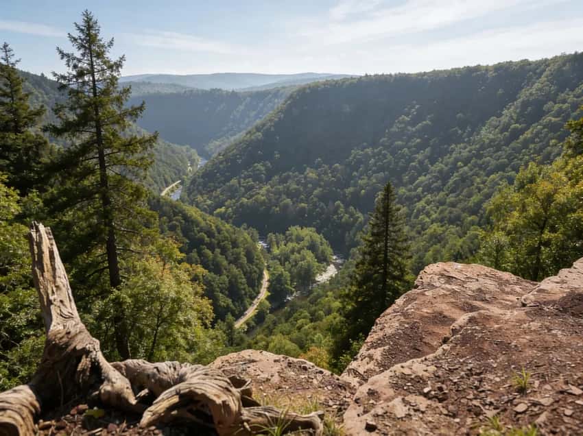
Colton Point State Park (West Rim)
This park offers rustic charm from the CCC era. The roads are gravel and the facilities are primitive. You will find far fewer people here.
Sunsets are better at Colton Point because you face east across the gorge. The Rim Trail connects multiple overlooks over a one-mile stretch. Visit Colton Point if you want solitude and don’t mind pit toilets.
The Answer: Do Both. They’re 30 minutes apart. If you drove 4+ hours to get here, spend the extra 30 minutes.
Colton Point State Park - rustic charm and quiet views on the West Rim
The Trails: Rim vs. Gorge
Rim Trails (Easy Access, Big Views)
- Barbour Rock Trail (0.7 miles, ADA accessible): The secret weapon. It offers Leonard Harrison-quality views without the Leonard Harrison crowds. It’s on the West Rim near Colton Point.
- Rim Trail at Colton Point (1 mile): An easy walk connecting multiple overlooks. Quiet and scenic.
- Otter View at Leonard Harrison (0.6 miles): A short walk from the main overlook to a south-facing vista.
Gorge Floor (The Real Adventure)
This is why people come. It is crushed limestone with a 2% grade. USA Today rated it one of the best bike trails in the country.
The trail runs from Wellsboro Junction to Jersey Shore. The most scenic section is the 16-mile stretch from Ansonia to Blackwell. This passage takes you through the heart of the gorge.
- Distance: 62 miles total (most popular: Ansonia to Blackwell, 16 miles)
- Time: 2-4 hours biking, 5-7 hours hiking (for the 16-mile section)
- Best Access Points: Ansonia (northern), Blackwell (southern), Rattlesnake Rock (mid-point)
What to Expect on Pine Creek Rail Trail
The PA Grand Canyon reveals itself on the Rail Trail like nowhere else. You ride through 1,400-foot gorge walls. You pass through old-growth hemlock and rhododendron tunnels.
Pine Creek flows alongside the trail. It is a ribbon of water that flows north. This is unusual for Pennsylvania. The current carries seeds from southern Appalachian flora that survive in the gorge’s microclimate.
The trail surface is packed crushed limestone. It is smooth and forgiving. For the core 16-mile section, you are riding on a railroad grade from the 1800s.
This means minimal elevation change and easy pedaling. Even novice cyclists handle this comfortably.
Summer brings crowds and the access points fill by 9 AM on weekends. Rent bikes in Wellsboro or Ansonia. Shuttles are available so you can ride one-way downhill instead of retracing your route.
Winter (Dec to Feb) is quiet and cold. It is excellent for wildlife. Bald eagles perch in trees along the creek. They are visible with binoculars or telephoto lenses.
Morning temperatures hover near freezing, but midday warms to 40 or 50 degrees. Bring at least 2 liters of water. There are no water sources on the trail except Pine Creek. A filter is required if you pull water from the creek.
Hikers also use the Rail Trail, though bikes dominate. It’s an excellent full-day option if you’re not ready for the West Rim Trail’s backpacking commitment but want to experience the gorge floor immersion.
Turkey Path (The Stairmaster)
The Turkey Path is the steep descent from Leonard Harrison to the gorge floor. It is the most popular hike in the canyon. It passes multiple cascading waterfalls on Little Fourmile Run and connects to the Rail Trail at the bottom.
- Distance: 2 miles round trip (1 mile each way)
- Elevation: 800 ft descent (and 800 ft climb back up)
- Time: 2-3 hours round trip
- Difficulty: Strenuous (steep switchbacks, rocky, slippery when wet)
- Seasonal Closure: Closed from Thanksgiving to April due to ice and erosion
What to Expect on Turkey Path
The reputation of this trail is earned. It is relentless. The first half mile is pure descent on tight switchbacks. You will drop 300 feet in a very short distance.
Your quads will feel it on the way down. Your knees will feel it more on the way up. Bring trekking poles.
They are not optional here. They are insurance against a twisted ankle.
The payoff: cascading waterfalls appear around mile 0.5. Multiple drops are visible through hemlocks and rhododendrons. In spring, these waterfalls are high and active. They are fed by snowmelt and rain.
By summer, water flow drops significantly and crowds increase. Arrive before 9 AM on weekends to avoid the queue at trailhead parking. Leonard Harrison usually fills by 10 AM on fair-weather Saturdays.
The rock underfoot varies from sharp sandstone to moss-covered boulders. After rain, the moss becomes extremely slippery. Waterproof hiking boots with aggressive tread are essential.
Many hikers wear water shoes for the splash zones near waterfalls. The final 0.5 miles opens into old-growth hemlock groves before reaching the gorge floor.
The return trip is the gut-check. You have 800 feet of elevation gain over one mile of steep switchbacks. There is zero shade in many sections.
Most hikers take up to two hours going up compared to 45 minutes coming down. Summer heat makes the return brutal. Spring and fall are much kinder.
⚠️ Critical: Turkey Path closes from late November to April due to ice, erosion, and trail maintenance. Before you go, check conditions at the Leonard Harrison Visitor Center. Plan for 3 liters of water and snacks. There are no water sources on the trail.
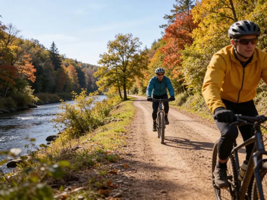
Pine Creek Rail Trail - voted one of the best places to bike in the world
Backpacking (For the Committed)
-
West Rim Trail (30 miles, moderate to strenuous): Outside Magazine called this the best hike in Pennsylvania. This point-to-point trail skirts the western rim of the canyon with dramatic overlooks.
-
Distance: 30 miles point-to-point
-
Elevation: ~5,600 ft cumulative gain
-
Time: 2-3 days backpacking
-
Trailheads: North: Colton Road (near Ansonia), South: PA Route 414 (Rattlesnake Rock)
The West Rim Trail is a challenge your legs will feel for days. It is 30 miles of ridge walking with 5,600 feet of cumulative elevation gain. This means roughly 2,800 feet up and 2,800 feet down.
The pain is distributed across continuous rolling climbs. The stunning canyon overlooks are your constant reward.
The trail surface alternates between soft forest floor and exposed sandstone ridges. Footing requires attention on the rocks.
Elevation gain is relentless but gradual. You won’t face 500-foot climbs. Instead, you’ll deal with steady 100-foot to 200-foot ascents that repeat throughout the hike.
Day 1 (North to Midpoint): The northern section from Colton Road to Barbour Rock (6 miles) is the best part. It features dramatic overlooks, old-growth hemlock groves, and minimal crowds.
From Barbour Rock to Bradley Wales picnic area (roughly 12 miles) is a grind. You will face rolling terrain and fewer dramatic views. This is where you find water and a reliable shelter option.
Day 2 (Midpoint to South): The section from Bradley Wales to Rattlesnake Rock redeems itself in the final miles. The southern ridges open up with expansive canyon vistas. Arrive at Rattlesnake Rock by 5 PM to avoid hiking in the dark.
Camping: Primitive sites exist throughout the trail. They are first-come, first-served and do not require permits. Popular weekends fill campsites early. Mid-week offers solitude.
Bradley Wales picnic area has a reliable water spigot. Everywhere else requires filtering from streams. Bear canisters are optional but recommended in fall when bears are more active.
Critical Details:
- Water Access: Bradley Wales is the only potable source. Plan your water strategy accordingly.
- Navigation: Cell service is zero in the gorge. Bring a physical map and compass. Trail junctions can be ambiguous in fog.
Shuttle: A point-to-point hike requires logistics. Pine Creek Outfitters offers shuttle services for hikers and bikers. Call ahead for pricing.
- Weather: Fall temperatures swing wildly. They can drop from the 60s into the 40s at night. Wind on exposed ridges is common. Spring is muddy until late May.
Day Hike Option: The northern section from Colton Road to Barbour Rock (6 miles round trip) is an excellent full-day outing if you’re not ready to commit to the full 30-mile backpack. Same dramatic overlooks, without the overnight logistics.
West Rim Trail - 30 miles of rugged backpacking along the gorge
Insider Tips: How to Hike the PA Grand Canyon Like a Local
Parking Strategy
Leonard Harrison State Park’s main overlook lot holds about 80 vehicles. The overflow lot adds another 40. On sunny October weekends, it fills by 10 AM.
Colton Point State Park has ample parking but rougher road access. For the Pine Creek Rail Trail, Ansonia and Blackwell access points fill by 9 AM on weekends.
Arrive before 8:30 AM on weekends. Tuesday through Thursday are nearly empty.
If you arrive late, try the secondary lots at Dinnerbell Road near Leonard Harrison. They offer pull-offs with alternate parking and footbridge access to trails.
Seasonal Reality
April to May: Turkey Path waterfalls are high with snowmelt. Wildflowers bloom into late April. Water crossings on the West Rim Trail can be thigh-deep and swift after heavy rain.
Ticks emerge mid-May. Mud is substantial.
June to August (Summer): Peak crowds and heat. The gorge is humid and buggy. Rail Trail biking is pleasant in early morning before crowds arrive. Plan early starts and finish by 2 PM to avoid afternoon heat and crowding.
October 5 to 20 is prime foliage. The West Rim Trail ridges are spectacular. Expect crowds at Leonard Harrison.
Temperatures swing from the 70s during the day to the 40s at night. The stabilize weather still requires layers for the cool mornings.
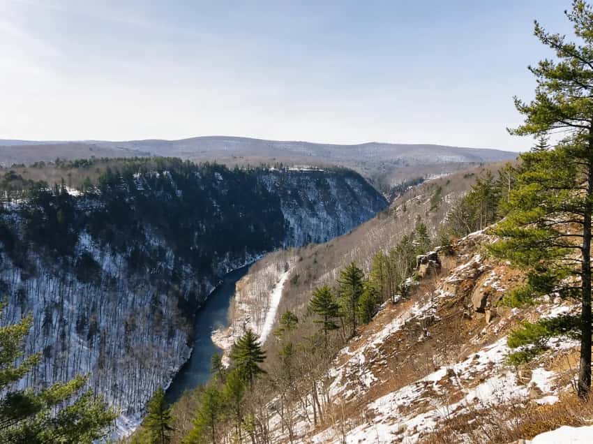
November to February: Colton Point’s seasonal road often closes. Leonard Harrison stays open. Turkey Path is closed. Bald eagles are active along Pine Creek.
Bring binoculars. Trail hiking is quieter but cold. Microspikes help on icy overlooks.
Rattlesnake Awareness
Timber Rattlesnakes and Copperheads live on the sunny rims. They are active from May through September. They hide under rocks and in tall grass on warm days.
On-trail hiking reduces risk significantly. Watch your hand and foot placement on scrambles. If you hear the dry buzzing rattle, back away slowly. Stay at least six feet back.
Shuttle Services & Logistics
For the West Rim Trail and longer Pine Creek Rail Trail sections, Pine Creek Outfitters in Wellsboro provides shuttle services and bike rentals. Call ahead because they are busy on fall weekends. For Leonard Harrison and Colton Point updates, contact the Visitor Center.
What You Need to Know Before You Go
It’s a Weekend Trip, Not a Day Trip
The PA Grand Canyon is over four hours from Philadelphia or Pittsburgh. Plan to stay overnight. Wellsboro is a charming gaslight town ten miles away. You can also camp at Colton Point for a more rustic experience.
Cell Service Is Dead
It is non-existent in the bottom of the gorge. On the rims, it’s spotty at best. Download your maps before you arrive.
Winter Closes Colton Point
The seasonal roads to Colton Point are often unmaintained or closed in winter. Leonard Harrison stays open year-round, though the Turkey Path may be icy.
Rattlesnakes Are Common
Timber Rattlers love the sun-warmed rocks on the overlooks and the West Rim Trail. Watch where you step and give them space.
Camping & Lodging
The campground has 25 sites and is first-come-first-served. Facilities are primitive with pit toilets and no showers. Sites are $20 a night. It offers direct access to rim trails and overlooks.
Wellsboro: The charming gaslight town is 10 miles from Leonard Harrison. It has hotels, B&Bs, and restaurants. It’s the best base if you want amenities after a day of hiking.
Primitive Camping: Allowed along the West Rim Trail for backpackers (no permit needed for single-night stays). Practice Leave No Trace principles.
Best Time to Visit
- Fall (Foliage): Peak season is typically October 10-20. The gorge explodes with color. Experience massive crowds at Leonard Harrison on weekends. Visit midweek if possible.
- Summer (Biking): Best for biking the Rail Trail. Early mornings are perfect before the heat builds.
- Spring (Waterfalls): Cascades are flowing on the Turkey Path. Wildflowers bloom mid-April to May.
- Winter (Solitude): The gorge is quiet and beautiful. Bald eagles are active along Pine Creek specifically between December and February.
Photography Tips
Turkey Path Waterfalls: Spring brings high water and dramatic cascades. Shoot in the morning when the sun creates soft backlighting through the hemlocks. Use a neutral density filter for silky water effects.
The classic shot happens at Otter View Trail, which is a short walk from the main parking lot. Arrive 45 minutes before sunrise. The gorge often fills with fog at dawn, creating layered atmospheric light.
Later morning (8 to 10 AM) is optimal for gorge wall texture and shadow detail. Avoid midday when contrast flattens.
Colton Point Sunrises: Face east across the gorge toward Leonard Harrison. The sun rises behind the ridges and backlights the gorge walls. This is exceptional 30 minutes before and after sunrise.
West Rim Trail Foliage: October offers warm golden light on maples and birches. Shoot late in the afternoon for raking light on the gorge walls. Wide apertures work well for foliage layers.
Golden hour (4 to 6 PM in summer) bathes the overlook in warm light. Gorge walls glow orange and pink. Crowds thin after 5 PM.
Arrive 30 minutes before sunset for positioning. ND filters and tripods help control sky exposure.
Bald Eagles: In winter, scan the creek-side trees from the Rail Trail. Sunrise is the best time to see them perched in tall sycamores. A telephoto lens is required for a safe distance.
Night Sky: The gorge has minimal light pollution. New moon nights (late fall/winter) are ideal. Tripod, wide lens (14-24mm), and 15-25 second exposures reveal stars over ridge silhouettes. Low light favors high ISO (3200-6400) and wide apertures (f/2.8 or wider).
FAQ
Which rim should I visit? Leonard Harrison for the classic view and amenities. Colton Point for solitude. Both if you have time.
Can you drive to the bottom? No public roads run along the river bottom. You drive to access points (access areas like Blackwell or Rattlesnake Rock) and walk or ride from there.
Is it free? Yes, admission to both state parks is free.
How long does it take? You can see the main overlooks in 2 hours. Hiking or biking takes a full day.
Explore More
- Explore more trails in Tioga State Forest beyond the canyon
- Check out Ricketts Glen State Park for Pennsylvania’s best waterfall hikes
- Visit the Poconos region for more waterfalls and family-friendly trails
- Explore the Laurel Highlands for whitewater and rugged wilderness