Shades of Death Trail: A Guide to Hickory Run's Drama
High-stakes scenery, house-sized boulders, and the truth behind the ominous name. Here's how to survive the scramble.
Shades of Death Trail: A Complete Guide to Hickory Run’s Most Dramatic Hike
I’ve hiked Shades of Death a dozen times, and it never gets old. This 4.8-mile out-and-back at Hickory Run State Park is one of Pennsylvania’s most visually striking scrambles, where dense forest gives way to an otherworldly boulder field that feels like nothing else I’ve experienced in PA. The name sounds scarier than reality; there are no documented deaths here. But I have watched people underestimate the technical scrambling and get spooked in the boulder field. Here’s what actually happens on this trail, and whether it’s right for you.
Key Takeaways
- Distance: four point eight miles (out-and-back)
- Difficulty: Moderate to difficult (scrambling required)
- Elevation gain: eight hundred feet
- Best season: May; October (avoid winter ice on boulder field)
- What makes it special: Unique boulder field geology; solitude; technical scrambling
Shades of Death Trail: Video Guide
Expert video guide showing the trail conditions and key viewpoints for this section.
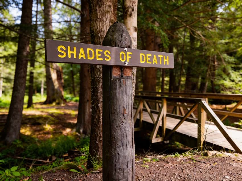
Why The Name? (And Should You Be Worried?)
The name comes from the boulder field itself: towering rocks cast dramatic shadows in low light, making the landscape feel ominous. It’s atmospheric, not literal. I’ve never seen someone hurt here, but I have watched hikers freeze up once they realize how exposed and technical the scrambling actually is. If you’re thinking “it’s probably fine,” it’s not. This demands respect.
You’ll do hands-and-feet scrambling over house-sized rocks with real drop-offs. This isn’t a walk in the woods. It’s technical terrain that requires fitness, balance, and scrambling comfort. If you’re not comfortable using your hands and testing footing carefully, skip this one.
The Route: What to Expect
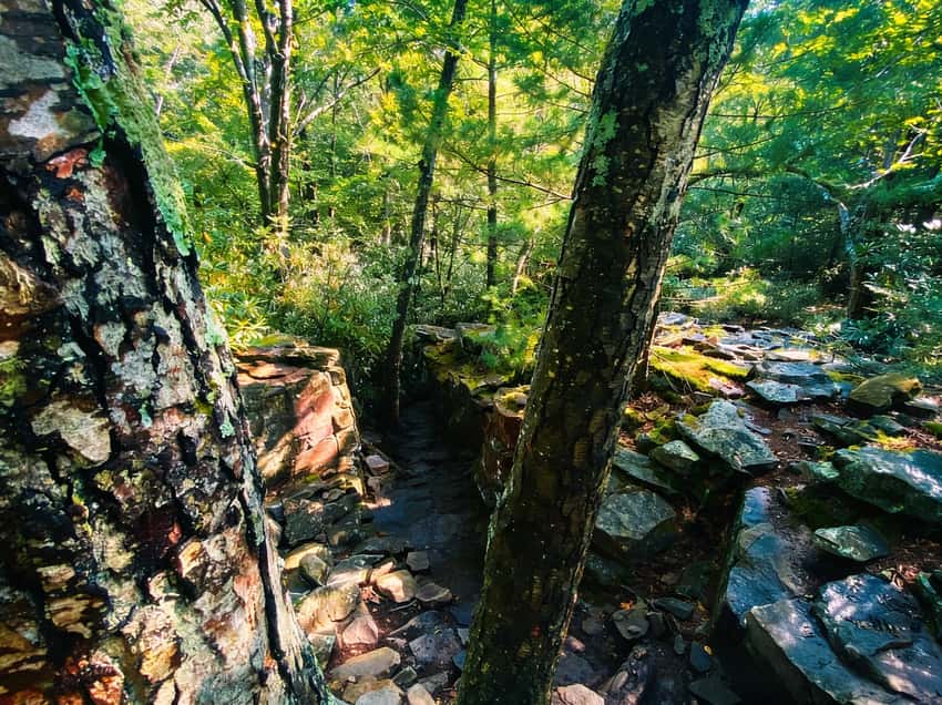
Trailhead to Forest Section (2.0 miles)
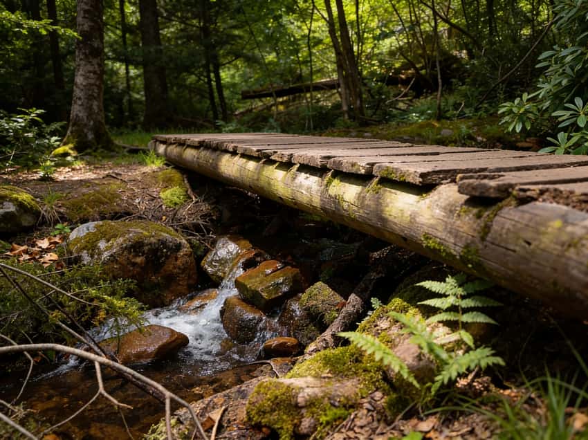
I always park at the main Hickory Run lot. The first two miles follow a well-maintained dirt trail through mixed hardwood forest with steady, gentle elevation gain, good for warming up before the scramble. You’ll cross several small streams and gain about 400 feet of elevation. The forest here is quiet and shaded; oak, maple, and hemlock dominate. When I’ve hiked in early summer, rhododendron blooms line the stream sections. Most hikers take about 45 minutes through this section at a moderate pace.
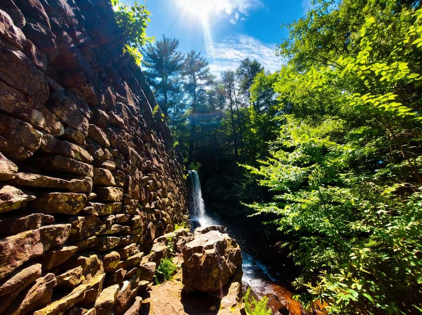
The Masonry Dams (Stametz Dam)
As you follow the creek, you’ll encounter several man-made masonry dams. The most impressive is Stametz Dam. These structures create beautiful, wide curtains of water that are a highlight for photographers. The juxtaposition of the structured stone dams against the rugged, mossy creek bed is what makes this trail unique compared to other Poconos hikes.
Boulder Field Approach (0.4 miles)
At the two-mile mark, everything changes. The forest opens up and you start seeing scattered boulders, first in clusters, then in overwhelming density. The trail shifts from hiking path to scrambling route. Hand placement becomes critical. You’ll pull yourself up 3-4 foot rock steps using your hands and feet. This section is steep and technical; most people slow down significantly here.
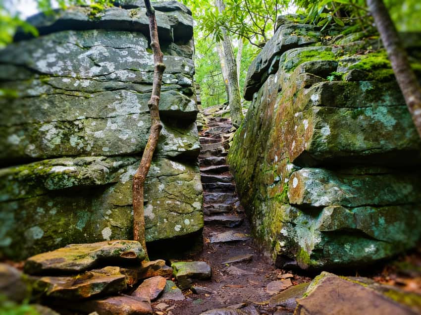
The Boulder Field Scramble (0.4 miles)
The heart of the hike is a half-mile of continuous boulder scrambling through chaotic, massive stone. Some boulders are house-sized; others create caves and overhangs you duck under. There’s no single “correct” route; you pick your path uphill toward the ridgetop, problem-solving as you go. Most scrambles take 20 to 30 minutes depending on your comfort level and fitness.
The rocks are rough granite and sandstone with solid friction when dry. Wet rocks are slippery; snow and ice make this genuinely dangerous. I don’t recommend winter visits unless you have microspikes and serious scrambling experience. Wet conditions can turn this into a risky section. If you’re not certain about footing, turn back.
The Ridgetop (0.5 miles to viewpoint)
Once you crest the boulder field, terrain opens up. You’re on top of the ridge with views across the Pocono plateau. On clear days, you see five miles of forest and pick out multiple ridgelines. Most hikers turn around here. The official trail continues, but the real scramble is done. You’ve got what you came for.
Geology: Why These Boulders Exist
The boulder field is a periglacial formation: 10,000+ years of freeze-thaw cycles after the last ice age. Water seeped into bedrock cracks, froze, and expanded, shattering rock. Summer thaws and gravity moved the fragments into the chaotic field you see today. This isn’t a glacial moraine (ice didn’t deposit these). It’s what happens when weather alone tears mountains apart.
The boulders you’re scrambling over are exposed bedrock of the Pocono Plateau, fractured in place. Understanding that context makes the landscape feel less random. Each boulder is evidence of how weather sculpts mountains over millennia. It’s a geology lesson you can touch.
Difficulty: Is It Right for You?
Good for this hike if you:
- Can hike four or more miles with regular elevation gain/
- Feel comfortable scrambling over rocks three to four feet tall/
- Don’t mind exposure (some scrambles have drop-offs of ten to fifteen feet)/
- Have decent balance and upper body strength/
- Are comfortable with route-finding (trails aren’t marked through boulder field)/
Better to skip if you:
- Have limited scrambling experience/
- Are uncomfortable with heights or exposure/
- Have joint issues that limit climbing/descending/
- Require a well-marked, obvious trail/
- Are visiting in winter (ice makes scrambling dangerous)/
Best season: May through October, but here’s what I’ve learned about the differences. I prefer May: water is high from snowmelt, rhododendrons sometimes still bloom, and crowds are light. October is beautiful and cool, but leaves make the rocks slippery. Summer is hot with zero shade on the ridge; I skip it. Don’t visit in winter or early spring. Ice on the boulder field is genuinely dangerous.
What to Bring
- Water: 2 to 3 liters minimum. No reliable water on the ridge; streams exist but mean stopping to filter./
- Footwear: Trail runners or hiking boots with ankle support. The boulder scramble hammers ankles; support matters./
- Layers: The boulder field is exposed and windy. Morning temps feel 10°F cooler than the trailhead./
- Navigation: Bring a map or offline trail app. No formal trail markers in the boulder field; it’s easy to veer off-route./
- Gloves: Optional but smart. Hands get raw on rough rock after 20+ minutes of scrambling./
- First aid: Ankle tape if you have weak joints. Scrapes and minor sprains are common./
- Sun protection: The ridge is exposed. Sunscreen, hat, and sunglasses essential; sunburn happens fast up there./
Practical Information
Parking: Hickory Run main lot. Arrive early on weekends. This isn’t a hidden trail. Parking fills by 10 am on nice days. I’ve shown up mid-morning and had to park in overflow.
Distance & Duration: 4.8 miles, 3 to 4 hours round-trip depending on scrambling speed. Plan 45 min forest section, 40 min boulder approach, 25 to 30 min boulder scramble, 15 min ridge, then reverse. Most hikers take closer to four hours when you account for hesitation in technical sections.
Elevation Profile: 800 feet total with the steepest section compressed into the final 0.4 miles. Not extreme elevation, but the boulder scrambling makes it feel harder than the numbers suggest.
Cell Service: Spotty at the trailhead, none in forest or on ridge. Download offline maps before you go.
Dogs: Allowed on leash, but the boulder field is rough on dogs. Smaller dogs struggle with 3 to 4 foot rock steps. I’ve watched people carry small dogs through the scramble, and it’s doable but awkward.
Safety Considerations
Scrambling accidents: Most injuries are sprains or strains from awkward footing. Move deliberately, test every handhold and foothold before committing your full weight, and don’t rush. I’ve seen people slip on dry rock by moving too fast and overcommitting to handholds.
Weather exposure: The ridge is exposed and windy. Afternoon thunderstorms develop quickly in summer. Start early and plan to be off the ridge by 2 pm. Thunderstorms move in fast, and you don’t want to be scrambling when lightning is possible.
Winter hazard: Ice on the boulder field in winter and early spring is genuinely dangerous. Rocks get slippery, and a fall has serious consequences. Don’t go if you see ice or wet conditions suggest ice is forming. Winter requires microspikes and real experience.
Route-finding: No blazes in the boulder field. You can get disoriented. Bring a map or offline app and mark your entry point if you’re at all unsure about retracing your steps.
Heat: Summer has zero shade on the ridge. Heat exhaustion is possible, especially if you underestimated scrambling speed. Carry more water than you think you need, and take breaks in the forest shade before and after the scramble.
Why This Trail Matters
Shades of Death offers something rare on the East Coast: exposed, jumbled bedrock you can touch and understand. The boulder field is a geology classroom: freeze-thaw cycles made visible in stone. It’s a tangible reminder of how weather sculpts mountains over millennia.
The trail is also a test. It’s not extreme, but it separates hikers who want a walk in the woods from those willing to scramble, use hands, and navigate uncertain terrain. That distinction matters. For scrambling enthusiasts, it’s an accessible intro to technical hiking. For experienced hikers, it’s a refreshing break from blazed trails and maintained paths.
Nearby Alternatives & Related Hikes
Hickory Run Boulder Field (same park): Flat, easy 1.2-mile walk with viewing platform, same geology, zero scrambling. If Shades of Death feels too technical, this is the move. You still get the boulder field experience. See our Hickory Run Boulder Field guide.
Pennel Run Trail (Pocono region): Similar difficulty, less crowded, with waterfall sections. Check our Poconos region guide for more options in the area.
Butternut Ridge Trail (Hickory Run): Moderate 3-mile loop without scrambling, same Pocono plateau geology. Good for warming up to technical terrain.
The Bottom Line
This trail isn’t for everyone: you need scrambling comfort and decent fitness. But if you’re ready to step beyond marked trails and use your hands, it’s one of Pennsylvania’s best experiences. The boulder field is dramatic, the geology is visible, and despite being close to major roads, it feels genuinely remote.
Start early, bring water, check the weather, and respect the rock. The “death” in the name is atmospheric, not literal. But the trail demands attention. Hike it that way, and you’ll understand why I keep returning to this corner of Hickory Run.
Reader Experiences
“The boulder field is otherworldly. Felt like hiking on an alien planet. Exhausting but worth every step.”;Sarah M., Delaware
“Not marked well, but the scrambling is the point. Brought my phone offline map and felt confident navigating. Would do again.”;Marcus T., Pennsylvania
“Underestimated the technical difficulty. Don’t come here expecting a casual hike. This is hands-on, real scrambling.”;Jennifer K., New York
What to Combine at Hickory Run
Shades of Death is a 3 to 4 hour commitment, which leaves plenty of day if you start early. Two natural partners sit within the same park and share the same geology.
Hickory Run Boulder Field: The boulder field at Hickory Run is a National Natural Landmark: a flat, easily accessible expanse of rocks spreading across six acres at the base of the plateau. The walk in is about 1.2 miles each way with almost no elevation change, so it works well as a cool-down after the scramble. You get the same freeze-thaw geology without any technical terrain.
Hawk Falls: If your group includes hikers who skipped Shades of Death, Hawk Falls is the fix. The trail is a short, easy walk to a wide curtain waterfall, and it finishes in under an hour round-trip. Pair it before or after the scramble to round out a full morning.
Both stops are inside the park or within a few minutes’ drive, so you can build a solid half-day at Hickory Run without leaving the area.
FAQ
How long does the boulder scramble actually take? Most hikers spend 20 to 30 minutes depending on fitness and comfort. Fast scramble through in 15 minutes; cautious hikers take 40+ minutes. Don’t rush through. Testing handholds is worth the time.
Can I hike this solo? Yes, it’s established trail with regular traffic. Bring offline maps, tell someone your plan, and don’t push timelines if conditions feel off.
Is the name really about deaths on the trail? No documented deaths here. The name comes from shadowy, ominous boulder field appearance. It’s atmospheric, not historical.
What if I can’t scramble? Hickory Run has an easier flat boulder field walk with a viewing platform. See our Hickory Run Boulder Field Guide for the details on the easier access road. It’s a legitimate choice, not a downgrade. For a waterfall hike without the rocks, check out Hawk Falls.
Best time to photograph the boulder field? Early morning when light rakes the rocks: dramatic shadows. Late afternoon works too. Avoid midday when the sun is overhead; you lose the shadow drama.
Last Updated: May 3, 2026 Trail Conditions: Check Hickory Run State Park website for closures Difficulty Rating: Moderate-to-Difficult (scrambling required)