Peters Mountain: Harrisburg's Rocksylvania Technical Challenge
A strenuous 4-mile loop with 900+ feet of gain, sharp shale scrambles, and railroad crossings. This is Harrisburg's premier training hike.
Key Takeaways
- Navigation: Park at the Clark’s Ferry Park & Ride (Google Maps | Apple Maps). GPS: 40.4235, -76.6342.
- Harrisburg’s Hardest Day Hike: A strenuous 4-mile loop with 900+ feet of gain and relentless Rocksylvania shale scrambles; intermediate to advanced hikers only.
- The Loop Strategy: Climb the steep Appalachian Trail (white blazes) up, then descend the gentler Susquehanna Trail (blue blazes) to spare your knees.
- Railroad Safety: Active Norfolk Southern tracks cross the trail near the base. Only cross at designated spots and never when a train is audible or visible. No headphones.
- Supportive Boots Mandatory: The sharp shale here cuts through trail runners. Proper hiking boots with aggressive tread and ankle support are essential.
Peters Mountain is the crown jewel of the Appalachian Trail near Harrisburg. It’s a 4-mile loop that stretches along the same ridgeline as the famous Hawk Rock and sits between beginner-friendly territory and serious backpacking terrain. This is where locals come to train, test their fitness, and prove they’re ready for bigger mountains.
The mountain is famous for its “Rocksylvania” shale, the notoriously jagged rock fields that make the Appalachian Trail through Pennsylvania grueling. For a day hike, those same rocks become the feature.
The views from Table Rock look directly down at the Susquehanna-Juniata confluence. The Clarks Ferry Shelter offers a historically significant rest point. And the loop strategy, ascending the white-blazed AT, descending the blue-blazed Susquehanna Trail, is a tactical choice that saves your knees.
This guide will show you how to hike Peters Mountain safely, navigate the railroad crossing, and why the descent strategy matters more than people realize.
The Loop: White Up, Blue Down
The Hike
Distance: 4 miles round trip (loop)
Elevation Gain: 900+ feet (relentless climbing)
Difficulty: Strenuous. Not for beginners. Hand-over-foot scrambling, technical footing, exposed sections.
Trailhead: Clark’s Ferry Park & Ride (GPS: 40.4235, -76.6342). Parking lot is small (15-20 spaces). Arrive before 9 AM on weekends or go on a weekday.
Trail Type: Rocky shale scramble, rooted sections, some exposed terrain. Hiking boots with ankle support are essential.
Blazes: White (Appalachian Trail up), Blue (Susquehanna Trail down)
Season: Spring (April-May) for wildflowers and clear skies. Fall (September-October) for comfortable temps and foliage. Summer is brutally hot on the exposed ridge. Winter is treacherous.
Time Reality: 2.5 to 3.5 hours for the 4-mile loop depending on pace, rest time, and scrambling difficulty. Most hikers take 3 hours.
The Ascent: Appalachian Trail (White Blazes)
The white-blazed AT climbs steeply from the parking area for 1 mile before hitting the ridge. This is a gut-buster.
The First 0.5 Miles: The railroad crossing happens almost immediately. You’ll see Norfolk Southern tracks running parallel to the trail. This is an active line, trains pass multiple times daily. Only cross at designated crossing points (marked with signage).
Never attempt to cross if you see a train within view or if tracks are occupied. If you’re uncertain, wait. The trail isn’t so critical that you risk your life.
The Climb: From 0.5 miles onward, the trail gains elevation relentlessly. The grade never flattens. Rocks get sharper.
The trail becomes a scramble. By mile 0.75, you’re using your hands to pull yourself up on technical sections.
Rocksylvania Reality: These aren’t smooth boulders. They’re jagged, knife-edged shale. Trail runners slip. Light sneakers are a liability.
Proper hiking boots with aggressive tread and ankle support are essential. Your ankles will appreciate it.
What to Expect:
- Steady, unrelenting uphill from mile 0.5 to mile 1.5
- Hand-over-hand scrambling on some sections
- Occasional views through the trees opening up as you climb higher
- No water sources on the AT section (carry what you need)
- By mile 1.5, you’ll break through to the ridge and the grade eases
Time: The ascent takes 60-90 minutes depending on fitness and scrambling speed.
The Ridge: Table Rock & Clarks Ferry Shelter
Once you reach the ridge (around mile 1.5), the trail flattens considerably.
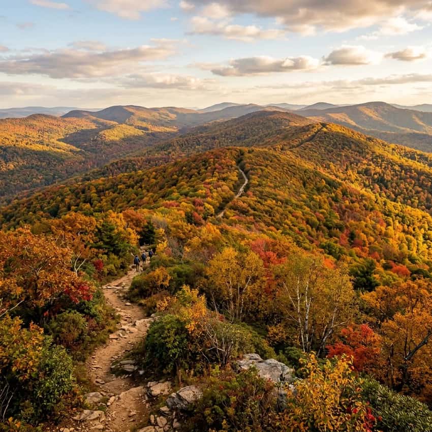
Table Rock: The first major landmark is Table Rock, a flat-topped outcropping with a 360-degree view. This is where most hikers take their first real rest and photos. The view looks down at the Susquehanna River below and the confluence with the Juniata River in the distance. On clear days, you can see 15+ miles down the river corridor.
Photography: This is the signature shot. Wide-angle lens (16-35mm) captures the full panorama. Early morning (6-8 AM) golden light strikes the river beautifully. Late afternoon (4-6 PM) creates warm side-lighting on the ridge.
Clarks Ferry Shelter (Mile 2): Continuing past Table Rock along the ridge, you’ll reach the historic Clarks Ferry Shelter around mile 2. This stone structure was built in the 1930s and still offers shade, a bench, and historically, a water source (check current status, reliability varies). This is your lunch stop. The shelter overlooks the river, the railroad bridge, and the valley below.
Local History: The shelter sits at a major crossing point on the Susquehanna. The nearby Clarks Ferry Bridge (still visible below) is a historic span connecting Harrisburg to Perry County. The shelter was built to serve hikers, and it still serves its purpose today.
The Descent: Susquehanna Trail (Blue Blazes)
This is where the loop strategy matters. The descent is critical.
Why Blue, Not White?: The white-blazed AT descends from the ridge via a series of steep, tight switchbacks. These switchbacks were engineered for efficient trail grade but create knee-punishing angles on descent. Your knees absorb impact from angles that feel unnatural.
The blue-blazed Susquehanna Trail offers a longer but gentler descent. It descends via different terrain, more forgiving angles, fewer switchbacks, a more natural descent pattern. Most experienced hikers take the blue trail down and never regret it.
The Descent Route: From Clarks Ferry Shelter (mile 2), you’ll continue past the shelter and pick up the blue-blazed Susquehanna Trail connector. This diverges from the white AT and descends via a different route back to the base.
What to Expect:
- Steady downhill with better angles than the AT switchbacks
- Rocky terrain but less sharp shale than the ascent
- Views of the river and valley visible through the trees
- Mile 3-4 returns you to the base and the parking area
- The descent takes 45-60 minutes
Knees Will Thank You: This isn’t just preference, this is pragmatic. AT hikers do the white-blaze both ways and their knees take a beating. Locals save themselves and recommend blue-down.
Critical Safety: The Railroad Crossing
Peters Mountain crosses active Norfolk Southern freight railroad tracks. This isn’t a scenic railroad or a heritage line. Trains run regularly, especially mid-morning and afternoon.
The Rule
Only cross at designated crossing points marked on the trail.
Never cross if:
- You see a train approaching within view
- Tracks are occupied (train stopped on the line)
- You can’t clearly see both directions for at least a quarter mile
The Headphone Warning
This is critical: Don’t hike Peters Mountain with headphones or earbuds. You need to hear approaching trains. A freight train moving at 50+ mph is nearly silent until it’s very close. Without auditory awareness, you lose your primary warning system.
What to Do If a Train Approaches
Stop. Move away from the tracks to clear ground (not on the trail). Wait for the train to pass completely. Only resume when the tracks are clear and you’ve waited 30+ seconds.
This happens rarely, but it happens. Respect the railroad.
Logistics: Pro Tips
Parking Strategy
Clark’s Ferry Park & Ride is a small lot (15-20 spaces). It fills quickly on weekends.
- Arrive before 9 AM on Saturdays/Sundays
- Weekday mornings are always available
- If the lot is full, don’t attempt to park on Route 147 (dangerous), find an alternative hike instead
Overflow: If the lot fills, you have no good backup. This trailhead has no overflow parking. Plan accordingly.
Seasonal Reality
Spring (April-May): Muddy in low sections. Wildflowers bloom. Weather is 55-70°F. Trails are drying but still soft in places.
Summer (June-August): Hot on the exposed ridge. The AT ridgeline offers zero shade. Start at dawn (6 AM) or skip it for shaded trails. Humidity is oppressive.
Fall (September-October): Ideal conditions. Cool (60-75°F), clear skies, foliage adds color. Busiest time. Go on a weekday if possible.
Winter (December-March): Icy and treacherous. The shale becomes a skating rink. Microspikes are essential if you go. Not recommended for most hikers.
What to Bring
Non-Negotiable:
- Proper hiking boots with ankle support (not trail runners)
- 2-3 liters of water (no reliable sources on the AT section)
- Trekking poles (reduce knee impact on descent)
- A headlamp (weather changes fast. Darkness comes quickly in fall)
- A light layer (temperature drops on the ridge)
Recommended:
- Snacks for the Clarks Ferry Shelter rest
- Phone with offline maps downloaded
- First aid kit (cuts from shale happen)
Photography Tips
Best Summit Shot: Table Rock at sunrise (6-8 AM) or golden hour sunset (4-6 PM). The river reflection and surrounding ridge colors are most dramatic. Wide-angle lens captures the full panorama. Polarizing filter cuts river glare.
Best Ridge Shot: Early morning or late afternoon side-lighting emphasizes the shale texture and rocky terrain. The technical nature of the trail is visually apparent with dramatic shadows.
Best River View: From Clarks Ferry Shelter looking south toward the bridge. The river bends dramatically here. Golden hour light transforms the water.
Insider Tips
The Loop Strategy: Take white up, blue down. This isn’t arbitrary. Experienced local hikers do this because the descent angles on the blue trail are forgiving compared to the AT switchbacks. Your knees will thank you.
Railroad Reality: Only one thing on this hike can kill you instantly, the railroad. Take it seriously. No headphones.
Listen. Never cross if you see a train.
Fitness Requirement: This isn’t “moderate difficulty hiking.” This is advanced hiking disguised as a day hike. If you’ve done Hawk Rock and felt strong, you’re ready for Peters. If Hawk Rock felt hard, wait.
Parking Discipline: The lot fills fast. Don’t waste time hoping for a spot. Arrive before 9 AM or don’t come on weekends.
Table Rock Rest: Don’t rush through Table Rock. This is the psychological midpoint and the reward. Sit. Eat a snack.
Enjoy the view. Your legs earned it.
Descending Safely: The blue-trail descent is longer but easier on joints. Descending safely means using trekking poles, taking small steps, and letting gravity do less work. People get hurt descending fast on rocky trails.
Best Time to Visit
Spring (April-May): Wildflowers, drying trails, cool temps (60-70°F). Muddy sections mid-trail but manageable.
Summer (June-August): Hot ridgeline (80-90°F). Best for early morning (before 8 AM). Otherwise, avoid.
Fall (September-October): Peak season. Cool (60-75°F), clear skies, foliage. Busiest time. Go weekdays for solitude.
Winter (December-March): Beautiful but dangerous. Icy shale. Microspikes required. Not recommended for most.
FAQ
Is Peters Mountain harder than Hawk Rock? Yes. Both are technical, but Peters gains more elevation (900+ vs. 750 feet) over a longer distance (4 miles vs. 2).
Peters is intermediate-to-advanced. Hawk Rock is moderate-to-challenging.
Do I need microspikes? Only in winter (December-March). Spring through fall, proper boots are enough.
Can dogs do this hike? Yes, but the shale will cut their paws without booties. Bring dog boots if your dog is with you.
How long does it take? 2.5 to 3.5 hours for the 4-mile loop. Most people take 3 hours including rest time.
Is the shelter always open? Yes. It’s an open-air structure maintained by the Appalachian Trail Conservancy. Water source reliability varies, check current reports.
Are headphones really that dangerous? Yes. Freight trains are nearly silent until they’re very close. Headphones mask your primary warning system. Don’t use them here.
Explore More
Nearby Appalachian Trail Hikes:
- Duncannon Hawk Rock (15 minutes): Similar Rocksylvania terrain, steeper but shorter. Good warmup hike.
- Mount Tammany Loop (45 minutes): Larger-scale AT scrambling with hand-over-hand climbing.
- Hawk Mountain Sanctuary (60 minutes): Raptor migration overlook with similar ridge exposure.
Other South Central PA Technical Hikes:
- Governor Dick Mt. Gretna (20 minutes): Tower views and bouldering. Similar technical terrain.
- Valley Forge Mount Joy (50 minutes): Moderate wooded climbing without the shale exposure.
Regional Guides:
- Full South Central PA region guide for more Harrisburg-area hiking
- Appalachian Trail in Pennsylvania for thru-hiking context and section info
Similar Technical Challenges:
- Laurel Ridge Trail: 70 miles of rugged Appalachian backcountry (multi-day)
- Kishacoquillas Creek Valley: Technical creek scrambling near State College
Peters Mountain is proof that the best hikes are near home. Harrisburg hikers have world-class technical terrain steps away from parking lots. This is a training ground.
This is where fitness gets tested. This is where you earn views of two rivers merging.
Arrive early. Climb hard. Protect your knees on descent.
Respect the railroad. Then grab a burger at The Doyle Hotel in Duncannon, you’ve earned it.