Stony Valley (SGL 211): Abandoned Places, Boxcar Rocks & Industrial Ruins
A 40,000-acre wilderness near [Harrisburg](/trails/best-hikes-near-harrisburg/) with abandoned mining towns, a mystery stone tower, and the massive Chinese Wall (Boxcar Rocks). Hunting orange mandatory.
Key Takeaways
- Navigation: Use the Cold Spring Road access point (Google Maps | Apple Maps). GPS: 40.4014, -76.8184. Note: Cold Spring Road closes Dec 1-March 31 annually.
- Boxcar Rocks (The Chinese Wall): A massive, jagged conglomerate rock formation that creates a 200-foot barrier across the landscape.
- Blaze Orange is Mandatory: This is active hunting territory (State Game Lands 211). You and your dog must wear fluorescent orange.
- Industrial Ruins: Visit the Yellow Springs abandoned town ruins and find the abandoned “General” steam shovel resting in the forest.
- Tick & Snake Territory: This is dense wilderness; treat gear with Permethrin and watch for timber rattlesnakes in rocky areas.
Stony Valley is Pennsylvania’s excellent wilderness playground. It’s not as famous as Ricketts Glen or the Poconos, but it’s bigger, 40,000 acres of State Game Lands where the only sounds are creeks, wind, and occasionally train whistles from the historic railroad grades that carved this valley.
The valley is defined by history. Like Centralia or Concrete City, the valley is filled with abandoned mining operations, abandoned settlements, and industrial relics.
The massive Boxcar Rocks formation (locals call it The Chinese Wall). And underneath it all, the ecological recovery of a landscape humans tried and failed to fully extract from.
This guide shows you how to navigate Stony Valley safely, find the ruins that most people miss, and respect the fact that this is active hunting country. You’re a guest here, and the rules matter.
The Landscape: Rocksylvania Meets History
Stony Valley’s geology is dramatic. The Boxcar Rocks formation rises as a massive conglomerate wall, hundreds of feet high, jagged and impressive. The valley floor follows Rausch Creek, an old railroad grade, and traces of the Susquehanna and Schuylkill Railroad that operated through here in the 1800s.
The history is everywhere. Stone chimneys from abandoned mining operations. The remains of Yellow Springs, a town that briefly thrived and then became ruin.
Equipment left rusting in the woods. The valley tells a story of extraction, coal, iron ore, timber, and what’s left when the extraction stops.
For hikers, this is a place where geology and human history intersect. You’re walking through active recovery.
The Main Attractions
Boxcar Rocks (The Chinese Wall)
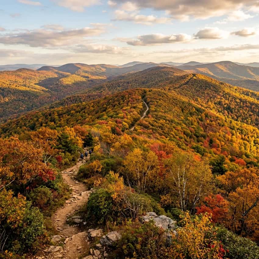
The Boxcar Rocks formation is Stony Valley’s most iconic feature. A massive wall of conglomerate rock rises 200+ feet, created by ancient glaciation and geologic pressure. Locals call it “The Chinese Wall” for its scale and the way it creates a barrier across the landscape.
Location: Accessible via the Whitetail Loop or via Cold Spring Road approach
What to Expect:
- A genuine geological wonder, not the polished boulders you see elsewhere, but raw, jagged conglomerate
- Scale is impressive. Bring a wide-angle lens to capture it
- Hiking difficulty: Moderate scrambling to reach the base and explore around it
- Crowds: Very few. This isn’t a popular Instagram spot
- Photography: Wide-angle (16-35mm) captures the full wall height. Late afternoon side-lighting emphasizes the texture
The Whitetail Loop: The loop accesses Boxcar Rocks from multiple angles and offers a full exploration of the formation. Total distance depends on route choice, but 4-6 miles is typical.
Yellow Springs: The Abandoned Town
Yellow Springs was a mining and industrial community in the 1800s. It thrived briefly, then faded as the mining economy collapsed. What remains are stone chimneys, building foundations, and scattered industrial equipment.
The “General” Steam Shovel: The most famous artifact is an abandoned steam shovel, a massive piece of heavy equipment left rusting in the forest. It’s located in the Yellow Springs vicinity, accessible via the Rausch Creek trail network. Finding it requires some trail knowledge or a GPS coordinate from local hikers (coordinates are shared in hiking forums and Facebook groups dedicated to PA ruins exploration).
What to Expect:
- Hiking difficulty: Easy to Moderate (trail follows Rausch Creek, relatively flat)
- Trail condition: Well-used but not maintained to day-hike standards. Roots, rocks, occasional water crossings
- The chimneys: Stonework that has survived 150+ years exposed to weather
- Atmosphere: Genuinely eerie and historical. Fewer tourists than other PA abandoned towns
- Photography: Macro shots of rust and decay. Wide shots showing how the forest is reclaiming the structures
Finding the Ruins: Yellow Springs Trail and Rausch Creek Trail are the main approaches. Current conditions and exact coordinates are best sourced from recent trip reports on Reddit or hiking-specific forums (AllTrails, Uncovering PA, etc.).
Table Rock (Dauphin)
A smaller but scenic overlook connected to the Stony Valley trail network. Table Rock offers views of the valley and is sometimes accessed as part of longer loops.
What to Expect:
- Smaller than Peters Mountain’s Table Rock, but still a quality overlook
- Accessible from either Gold Mine Road or Cold Spring Road approaches
- Good rest point and photography stop if doing a longer valley loop
- Difficulty: Moderate scrambling to reach the top
Critical Logistics: Orange Rules & Gate Closures
Fluorescent Orange Mandatory
This is active hunting territory. Pennsylvania Game Commission (PGC) rules require hikers to wear blaze orange during hunting seasons.
When Orange Is Mandatory:
- Rifle deer season: October 1-January 31 (peak: October 1-December 31)
- Spring turkey season: April-May (specific dates vary annually)
- Other seasons: Check PGC website for archery and special seasons
What “Blaze Orange” Means:
- A vest, hat, or jacket in International Blaze Orange (fluorescent orange)
- 400-500 square inches of visible orange is typical (check current PGC guidelines)
- Camo is fine as long as orange is visible
- Your dog should wear orange too
Why It Matters: Hunters use scent, sound, and visibility to identify game. You being visible prevents tragedy. This isn’t optional. It’s essential.
Gate Closures: Cold Spring Road
Important: Cold Spring Road, the primary access route to Stony Valley, closes December 1-March 31 annually for wildlife management and maintenance.
During Closure:
- You can’t drive Cold Spring Road
- Use Gold Mine Road as the alternate access (adds 10-15 minutes and is lower-clearance risky if roads are wet)
- Plan accordingly if visiting winter. Check current road conditions
Current Status: Always verify gate status and road conditions before driving to Stony Valley. PGC updates closure dates on their website, and local hiking groups monitor road conditions on Facebook and Reddit.
Vehicle Requirements
Both Cold Spring Road and Gold Mine Road can be rough.
- Low-clearance cars: Use with caution, especially after heavy rain
- AWD/4WD: Recommended if roads are muddy or snowy
- Check conditions: Call ahead or check hiking forums for current vehicle reports
The Tick & Snake Reality
Stony Valley is prime tick habitat. The dense forest, high humidity, and wildlife population make this tick country.
Tick Prevention:
- Treat clothing with Permethrin before hiking
- Wear light-colored clothing so ticks are visible
- Tuck pants into socks (looks goofy, prevents leg ticks)
- Check yourself thoroughly after returning to your car
- Check for ticks multiple times over the next week (some take hours to attach)
Snake Awareness: Timber rattlesnakes and copperheads inhabit the valley. They’re not aggressive, but they exist.
- Make noise as you hike (rattle a bell, talk)
- Never stick hands into places you can’t see
- Wear boots and long pants
- If you see a snake, back away slowly and give it space
This is real wilderness. Respect it.
Trail Approaches & Route Options
Gold Mine Road Approach
Access via Gold Mine Road (start from Route 233 near Wiconisco). This approach reaches the northern part of the valley and the Rausch Creek trail system.
Advantages: Lower-traffic, reliable access year-round Disadvantages: Lower clearance vehicles struggle. Adds distance for some routes Best for: Reaching Yellow Springs ruins and Rausch Creek trails
Cold Spring Road Approach
The main traditional access (CLOSED December 1-March 31). Starts from Route 443 near Dauphin.
Advantages: Direct access to Boxcar Rocks and most popular loops Disadvantages: Seasonal closure, can be muddy Best for: Boxcar Rocks/Whitetail Loop when road is open
Route Options by Interest
For Boxcar Rocks Focus
The Whitetail Loop: 4-6 miles depending on exact route. Moderate difficulty. Access via Cold Spring Road (when open) or Gold Mine Road approach. Encounters the Chinese Wall from multiple angles and includes varied terrain.
Best Season: Fall (September-October) or spring (April-May). Winter access complicated by gate closure.
Time: 2.5-4 hours depending on pace and photo stops.
For Abandoned Places
Yellow Springs Trail + Rausch Creek Trail: 3-6 miles depending on route choice. Easy-to-moderate difficulty. Follow Rausch Creek to access the abandoned structures. The “General” steam shovel is the highlight, but finding it requires current coordinates from local hikers.
Best Season: Spring-fall. Summer can be buggy and hot. Winter is difficult due to potential muddy conditions and gate closure.
Time: 2-3 hours for a focused ruins exploration.
For Table Rock Overlook
Table Rock Loop: Various approaches possible. 2-4 miles typical. Moderate difficulty.
Access from either Gold Mine Road or Cold Spring Road. Good for combining with Boxcar Rocks or ruins hikes.
Best Season: Fall for foliage, spring for wildflowers.
Time: 1.5-3 hours depending on additional routes added.
Photography Tips
Best Boxcar Rocks Shot: Golden hour (6-8 AM or 4-6 PM) side-lighting emphasizing the rock formation’s texture and scale. Wide-angle lens (16-35mm) captures the height. Include a hiker for scale.
Best Ruins Shot: Atmospheric shot of a stone chimney surrounded by forest regrowth. Macro focus on rust and decay details on the steam shovel. Overcast days work well for even, soft light.
Best Landscape Shot: Valley perspective showing the Boxcar Rocks wall in the distance with forest in foreground. Fall foliage (September 25-October 15) provides color. Late afternoon light creates depth.
Insider Tips
Blaze Orange is Non-Negotiable: This isn’t a preference. It’s essential. Wear it. PGC rules are real, and accidents happen.
Gate Closure Planning: If you want to visit December-March, plan Gold Mine Road access or save the hike for April-November when Cold Spring Road is open.
Tick/Snake Reality: This is untamed land. Treat it with appropriate respect and preparation. Permethrin-treat your clothes before arriving.
Current Coordinates: The exact location of the “General” steam shovel changes based on community sharing. Don’t rely on old trip reports. Check recent Reddit posts or hiking Facebook groups for current coordinates.
Low-Clearance Vehicles: If your car sits low to the ground, check current road conditions before committing. Gold Mine Road especially can be rough after rain.
Parking at Trailheads: Check for parking signs and verify you’re parked legally. PGC areas sometimes have specific parking restrictions.
Leave No Trace Extra Care: Stony Valley is recovering wilderness. Stay on marked trails, pack out all trash, and avoid disturbing historical structures.
Best Time to Visit
Spring (April-May): Wildflowers, manageable tick load, gate open. Wear orange during turkey season (check dates).
Summer (June-August): Hot and buggy. Tick load is high. Fewer hunters, so orange less critical but still recommended. Trail muddy in low spots.
Fall (September 25-October 15): Peak foliage, comfortable temps, low humidity. Ideal season. Hunting season active, orange mandatory.
Winter (December-March): Cold, icy, isolated. Gate closure limits access. Not recommended for most.
FAQ
Do I need to wear orange in summer? Check PGC website for current seasons. Archery season is September-December. Other seasons vary. Conservative approach: always wear orange.
Can dogs hike Stony Valley? Yes. Put orange on your dog too. Keep it on leash during hunting seasons.
How do I find the General steam shovel? Check recent Reddit/AllTrails trip reports for current GPS coordinates. Locations change based on trail conditions and community sharing.
Is Stony Valley suitable for beginners? It depends on the route. Rausch Creek trails are easy. Boxcar Rocks loops are moderate. Both require awareness of hunting season and tick preparation.
Can I camp overnight? Backcountry camping is allowed with PGC permit. Check their website for current rules. This is primitive wilderness camping.
Explore More
Nearby Abandoned Places & History Hikes:
- Centralia (30 minutes): Coal mining town buried by burning coal seam. Surreal landscape.
- Concrete City Ruins (45 minutes): Abandoned apartment complex slowly reclaimed by forest.
- Abandoned Turnpike (20 minutes): Historic tunnels and early infrastructure ruins.
Other South Central PA Outdoor Hikes:
- Duncannon Hawk Rock (20 minutes): Appalachian Trail technical hiking without the history of ruins.
- Peters Mountain (25 minutes): Rocksylvania challenge hike with railroad crossing.
Regional Guides:
- Full South Central PA region guide for more Harrisburg-area hiking
- Abandoned Places PA comprehensive feature guide
Similar Wilderness Experiences:
- Pine Creek Gorge: 60 minutes north, larger wilderness with less industrial history
- Big Spring State Park: 40 minutes south, similar Susquehanna watershed with easier access
Stony Valley rewards hikers who respect it. Wear your orange. Prepare for ticks. Check the gate status.
Find the General steam shovel rusting in the forest. Walk the base of the Chinese Wall. See where history tried and failed to extract everything from this land.
This is where the Appalachian Mountains remember who they are before humans showed up. And what remains when humans leave.