Poconos Hiking Guide: Waterfalls, Trails & Essential Tips
The Poconos offer world-class waterfalls and hiking - but Glen Onoko is closed, Bushkill costs money, and you need orange in hunting season. Complete guide to Ricketts Glen, Delaware Water Gap, Hickory Run, and the best trails near Stroudsburg and Jim Thorpe.
Key Takeaways
- Ricketts Glen Strategy: Avoid the crowded lower Glens lot. Park at the Lake Rose trailhead instead. This puts you at the top of the loop, allowing you to tackle the steep 1,100-foot descent and climb first while your legs are fresh, ending with a flat, shaded walk.
- Mount Minsi Shortcut: Mount Tammany (NJ) is the most crowded trail in the region. For a nearly identical view of the Water Gap with 50% less traffic, hike Mount Minsi on the Pennsylvania side of the Appalachian Trail.
- Boulder Field Timing: Hickory Run’s Boulder Field is a literal parking lot of rocks. Visit after 4:00 PM; the tour buses are gone, and the low-angle sun creates dramatic shadows that make for much better photography.
- Lehigh Gorge Biking: Unless you want a 26-mile workout against gravity, rent your bike in White Haven and ride down to Jim Thorpe. Book the train shuttle in advance to bring you back up to your car.
- Glen Onoko Warning: The Glen Onoko Falls trail is permanently closed and patrolled. For a legal alternative with the same “deep gorge” feel, head to the Tumbling Waters Trail at the Pocono Environmental Education Center (PEEC).
The Poconos are defined by 21 waterfalls in a single park, a 16-acre boulder field you can walk across, and a gorge so steep it once supported a massive coal-loading operation. While the tourism boards sell “serenity,” the reality of hiking in Northeastern Pennsylvania is a mix of world-class geology and aggressive weekend logistics.
Why Hike the Poconos?
This region covers roughly 2,400 square miles of glaciated plateau, cut deep by the Lehigh and Delaware rivers. This unique geology creates the steep gorges and high-volume waterfalls the Poconos are famous for. The terrain is notoriously rocky, part of the “Rocksylvania” legacy, but the rewards are the highest concentration of waterfalls in the Eastern US outside of the deep South.
If you’ve spent any time hiking around Northeast Pennsylvania, you’ve probably heard locals talk about the Poconos like the mountains’ secret backyard. They kind of are.
The region is two hours from Philadelphia and two hours from New York City. Poconos hiking hits a sweet spot. It offers genuinely wild terrain that’s actually close to where millions of people live.
But here’s the thing about Poconos hiking that the tourism boards won’t lead with. It’s crowded. It requires early mornings and good planning. Some of the most famous trails are permanently closed.
That said, if you know what you’re doing, the Poconos hiking experience is exceptional. This means understanding the parking dynamics, the waterfall season, and where to find the angles that avoid the weekend crush.
You’ll see twenty-one named waterfalls, boulder fields, and gorges carved by glaciers. The forests turn into walls of flame every October.
The region covers roughly 2,400 square miles of glaciated plateau. It is cut deep by the Lehigh and Delaware rivers. This geology creates the steep gorges and waterfalls the Poconos are famous for. The terrain is rocky.
The climbs are steep. The forests are dense with hardwoods that shift from green to gold to rust.
Where to Hike: The Essential Parks
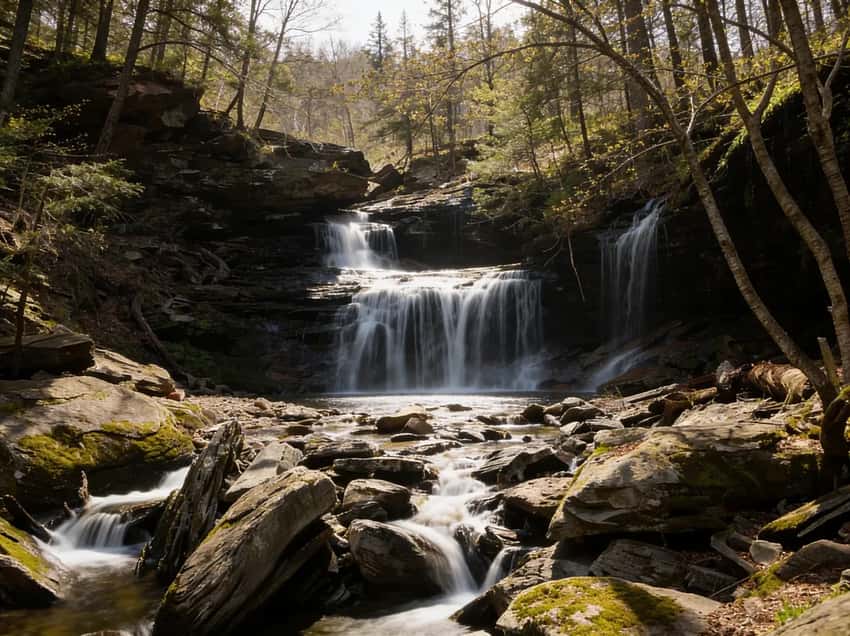
Ricketts Glen State Park
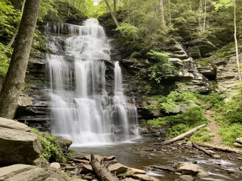
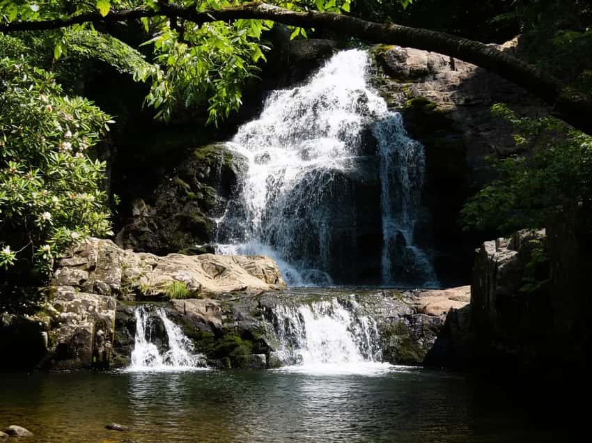
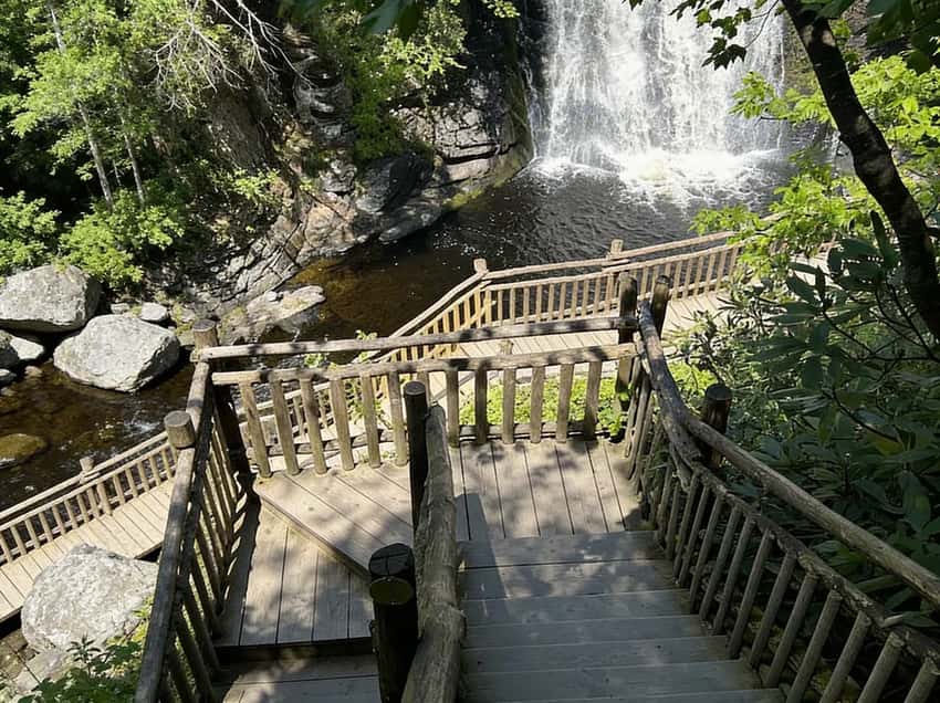
This is the crown jewel. The Falls Trail is widely considered the best day hike in Pennsylvania. It takes you past 21 named waterfalls ranging from 11 feet to the 94-foot Ganoga Falls within Ricketts Glen State Park.
- Distance: 7.2 miles loop
- Elevation: 1,000 ft cumulative gain
- Time: 4-6 hours
- Difficulty: Strenuous (steep stone steps, wet surfaces, slippery rocks)
- Highlights: 21 named waterfalls including Ganoga Falls (94 ft), Harrison Wright Falls (27 ft), Sheldon Reynolds Falls (36 ft)
- Best Time: Spring for high water flow, fall for foliage (mid-October peak)
- Trailhead: Route 118 parking areas (Beach Lot 2 or Lake Rose parking)
- Pro Tip: Arrive before 9 AM on weekends or the lots will be full
What to Expect
This is the best waterfall hike in Pennsylvania. It feels like it, especially on weekends. The trail is wet, slippery, and steep from the very first section.
The stone steps are polished by thousands of boots. This means they’re treacherous when wet or icy. Don’t even think about flip-flops. You need boots with aggressive tread.
The payoff is undeniable. Twenty-one named waterfalls, including the 94-foot Ganoga Falls, cascade through a dense forest corridor.
The falls are at their most impressive in spring. Peak water flow is usually April through May. The forest canopy is most photogenic in late September and early October.
Summer brings crowds and heat. The dense canopy helps, but the constant stone steps can feel relentless on an 85-degree day.
The Beach Lot 2 and Lake Rose parking areas fill by 9 AM on nice weekends. If you arrive after 9, you’re parking off Route 118 and walking an extra 20-30 minutes. Plan accordingly. Weekday mornings in spring and fall are your best bet for solitude.
Hiking boots with good traction are non-negotiable. The stone is always damp. Scrambling over wet rocks is how people get injured.
Bring trekking poles. They’ll save your knees on the descent through the steep sections.
Spring offers maximum water volume but there is mud on surrounding trails. Summer is the crowded season and can feel hot in the gorge. Fall is peak season for foliage tourists. This makes early starts critical.
Winter transforms the Falls Trail into a technical scramble with ice. Only experienced hikers with microspikes should attempt it.
⚠️ Warning: The parking lots at Ricketts Glen fill by 9 AM on nice weekends. Arrive early or plan to hike a secondary trail. The Falls Trail has steep stone steps and can be treacherous when wet or icy.
Do not bring children under 8 or anyone with a significant fear of heights. There are sections with exposure and scrambling.
Delaware Water Gap National Recreation Area
Managed by the National Park Service, the Delaware Water Gap National Recreation Area is a massive park that straddles the PA/NJ border. The PA side offers miles of the Appalachian Trail, but the most iconic view is actually on the Jersey side: Mount Tammany.
Mount Tammany (New Jersey side, but worth the drive)
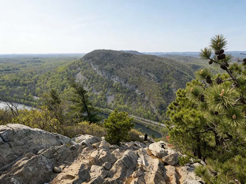
The Mount Tammany Loop offers one of the most iconic views in Pennsylvania, looking down into the gap from the Jersey side.
- Distance: 3.5 miles loop (Red Dot Trail)
- Elevation: 1,250 ft gain
- Time: 2-3 hours
- Difficulty: Strenuous (steep, rocky, hand-over-hand sections near summit)
- The View: Classic view looking down into the Delaware Water Gap
- Trailhead: Dunnfield Creek parking area (I-80 Exit 1 in NJ)
- Best Time: Fall for foliage, spring for wildflowers
- Pro Tip: The Red Dot Trail is steep but faster. The Blue Dot Trail is easier but longer (good alternative if knees are tricky).
What to Expect
Mount Tammany offers one of the most iconic views in Pennsylvania. Look down the river and see the gorge walls framing the vista perfectly. But getting there is no casual walk.
The Red Dot Trail climbs 1,250 feet in only 1.75 miles. The final approach involves hand-over-hand scrambling on a rocky ridge with legitimate exposure.
This is a classic case of “short but intense.” Most people finish this in 2-3 hours round-trip. This makes it a solid half-day adventure.
The boulder scramble at the top is terrain you either love or hate. If you’re comfortable with stone and heights, you’ll be fine. If you prefer an established path, take the Blue Dot Trail instead. It reaches the same point but is much gentler.
Parking & Access: Dunnfield Creek parking area fills on fall weekends. This is especially true from October 15 through 31 when foliage is at its peak. Parking is limited to roughly 40 spaces. Overflow is nonexistent.
Weekday mornings are your safest bet. Poconos hiking culture leans toward early starts. Being there by 8 AM puts you ahead of the traffic.
Footwear: Boots with good grip are essential for the final scramble. Rock scrambling in sneakers is asking for a twisted ankle on loose stone.
Seasonal Reality: Fall draws serious crowds chasing foliage. The view from the top is better in clear weather. Aim for morning starts to beat cloud cover moving in from the west. Winter ice can make the summit approach hazardous.
Spring and summer are quieter. Spring offers wildflower meadows around the base.
Dingmans Falls (Pennsylvania side)
- Distance: 0.5 miles round trip
- Elevation: Minimal (flat boardwalk)
- Time: 20-30 minutes
- Difficulty: Easy (accessible boardwalk)
- Highlights: 130-foot waterfall, accessible for all ages
- Best Time: Spring for high water flow
- Dogs: Not allowed on boardwalk
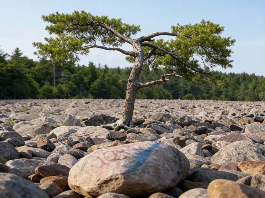
Hickory Run State Park is defined by the Boulder Field, a National Natural Landmark. It’s a 16-acre expanse of sandstone boulders left behind by the last ice age.
Boulder Field
The Boulder Field Trail allows you to walk across this massive expanse of stone, which is essentially a 16-acre parking lot of rocks.
- Distance: 0.5 miles from parking (or 3.8 miles via Boulder Field Trail)
- Elevation: Minimal if driving, 400 ft gain via trail
- Time: 30 minutes from parking, 2-3 hours via trail
- Difficulty: Easy to moderate (hopping across boulders requires balance)
- Access: Drive to Boulder Field parking area off PA Route 534
- Best Time: Fall for foliage, summer for exploration
- Pro Tip: The boulders are slippery when wet. Wear shoes with good grip.
What to Expect
The Boulder Field is pure geology. Sixteen acres of Devonian-age sandstone boulders were scattered here by glacial action. You are literally walking across a boulder field that is over 10,000 years old. If you have an hour and want to experience something unique in the Poconos, this is it.
The short drive-up option lets you explore the field without any serious climbing. For the full experience, take the Boulder Field Trail. This 3.8-mile path weaves through the forest and approaches the field from different angles.
Most people do a hybrid. They drive to the parking area and spend 30-45 minutes hopping around the stones. Then they do a loop back to the car.
The boulders are massive. Some are as big as houses. The gaps between them are deep and shadowed. It is a maze of stone with crevices that stay cool even in August.
Bring water and watch your footing. A turned ankle between boulders is a real risk.
Parking & Crowds: The Boulder Field parking area off Route 534 usually has space even on nice weekends. It has roughly 35 spaces. This makes it less chaotic than Ricketts Glen or Mount Tammany. This is a lesser-known spot for Poconos hiking with fewer crowds than the waterfall trails.
Footwear: Good hiking shoes or light boots are best. You’re balancing and hopping rather than scrambling. Full mountaineering boots are overkill. Good grip matters more than ankle support here.
Seasonal Reality: Summer is ideal. It is warm enough to explore but the dense canopy keeps the area shaded. Fall brings foliage to the surrounding forest. The contrast between gray boulders and amber trees is striking for photography.
Winter ice can make boulders treacherous. Spring mud can be frustrating if you do the full loop.
Hawk Falls
The Hawk Falls Trail is a short, 1.2-mile round trip that leads to a powerful 25-foot waterfall tucked into the forest.
- Distance: 1.2 miles round trip
- Elevation: 200 ft descent
- Time: 45 minutes to 1 hour
- Difficulty: Moderate (roots, rocks, stream crossings)
- Highlights: Powerful 25-foot waterfall with swimmable hole (freezing water)
- Trailhead: Hawk Falls parking area off PA Route 534
- Best Time: Spring for high water flow, summer for swimming (if you dare)
What to Expect
Hawk Falls is a 25-foot waterfall with a pool at the base. People actually swim in it during summer. The water is freezing year-round because it is fed by groundwater springs. But on a 90-degree July day, the shock is worth it.
The hike itself is straightforward. It is 1.2 miles round trip with 200 feet of elevation loss. You will have a 200-foot climb back up. The trail is rooty and rocky with some stream crossings.
You are in forest the whole way. It is shaded and cool even when the rest of Poconos hiking is baking.
This is a solid backup option when the big trails are packed. It doesn’t have the spectacle of Ricketts Glen or Mount Tammany. But it delivers waterfall scenery with fewer crowds.
Parking & Crowds: The Hawk Falls parking area has modest capacity of roughly 25 spaces. It is significantly less crowded than the big-name trails. Early afternoon is often quieter here than morning. Most Poconos hiking crowds hit the famous parks first.
Footwear: Regular hiking boots or sturdy trail shoes work fine. The roots and rocks are standard forest terrain. You don’t need technical scrambling gear.
Water & Swimming: If you are swimming, bring a change of clothes. A waterproof bag for your gear is also smart. The pool is deep and calm.
But the water temperature is genuinely cold. Expect 55°F even in summer.
Seasonal Reality: Spring means high water and powerful falls. But expect mud on the approach trail. Summer is peak swimming season. Expect a few other people at the pool.
Fall offers solitude and forest color. Winter ice can make the creek crossing slippery.
Lehigh Gorge State Park
The Lehigh Gorge State Park follows the Lehigh River and is a completely different vibe. The main artery is the D&L Trail (Delaware & Lehigh Trail), a flat, gravel rail-trail that runs for 26 miles through the gorge.
- Distance: 26 miles (Lehigh Gorge section: Jim Thorpe to White Haven)
- Elevation: Nearly flat (2% grade, follows the river)
- Time: Variable (most do 10-15 mile sections)
- Surface: Crushed stone, perfect for biking or walking
- Best Sections:
- Jim Thorpe to Glen Onoko (5 miles): Most scenic, gorge walls
- Glen Onoko to Rockport (8 miles): Remote, dramatic cliffs
- Usage: Multi-use trail (hikers, bikers, runners)
- Access: Multiple parking areas along Route 903
- Best Time: Fall for foliage, spring for high water in the river
- Pro Tip: Rent a bike in Jim Thorpe and shuttle back. The gorge walls are steep and dramatic, but hiking up them is limited.
The Lehigh Gorge D&L Trail is a flat rail-trail. It follows the Lehigh River through a gorge carved by glaciers. You can walk it, bike it, or run it. Plenty of people do all three.
The best approach is to rent a bike in Jim Thorpe. Ride one direction on the trail and take a shuttle back. This lets you cover distance without driving back to your car. The river is on one side.
Gorge walls are on the other. This creates a remote-feeling corridor despite the usage.
The vibe here is social. You’ll see families, dog walkers, and cyclists all using the same trail. The surface is well-maintained crushed stone. It is easy on joints and good for any fitness level.
The only challenges are distance and wind. The gorge acts like a funnel for afternoon wind from the west.
Key Sections: Jim Thorpe to Glen Onoko is the most scenic stretch. It has dramatic gorge walls. Glen Onoko to Rockport is more remote and has fewer people. Beyond that, the trail flattens and feels less dramatic.
Parking & Access: Multiple parking areas sit along Route 903. Jim Thorpe has the most infrastructure. You will find bike rentals, restaurants, and coffee shops there.
Parking is usually available. But summer weekends and fall foliage season bring crowds.
Social Factor: This is the easiest Poconos hiking option. It attracts casual hikers, cyclists, and families. If you want solitude, this isn’t it. If you want a social group outing, this is exactly it.
Seasonal Reality: Fall foliage is stunning with the river and gorge walls adding context. Spring brings high water and river drama. Winter is quiet but cold with wind.
Summer can feel crowded and hot in the exposed sections. There is minimal shade on the trail itself.
Cycling Notes: If biking, watch for pedestrians. The trail is multi-use and etiquette matters. Hikers have the right-of-way.
This brings us to a critical warning about Glen Onoko.
What the Tourism Sites Won’t Tell You
Poconos hiking has some specific rules and hazards that catch visitors off guard.
Glen Onoko is Closed (and Dangerous)
The Glen Onoko Falls Trail was once the most popular hike in the Poconos, but it was closed in 2019 due to extreme safety hazards.
Do not hike it. It is illegal and heavily patrolled. You will be fined.
Bushkill Falls Costs Real Money
Bushkill Falls bills itself as the “Niagara of Pennsylvania.” It is beautiful, with eight waterfalls and well-maintained boardwalks.
- Distance: 2 miles (Red Trail, longest loop)
- Elevation: Moderate (lots of stairs, but boardwalks)
- Time: 1.5-2 hours for full loop
- Difficulty: Moderate (stairs, but well-maintained boardwalks)
- Highlights: 8 waterfalls including Main Falls (100+ ft), Bridal Veil Falls, Laurel Glen Falls
- Admission: ~$22 per adult, ~$12 per child (family of four: ~$100)
- Season: Open April to November (closes for winter)
- Website: Bushkill Falls
It is also a private park. If you want boardwalks and amenities (gift shop, food, clean restrooms), the Bushkill Falls guide covers everything from pricing to the best loop strategy. If you just want waterfalls, Ricketts Glen is free.
Orange Rules on Game Lands
Many hiking trails in the Poconos cross into State Game Lands (like SGL 127). These are hunting grounds first, recreation areas second.
From November 15 to December 15, all hikers on Game Lands are required by law to wear 250 square inches of fluorescent orange. This covers your head, chest, and back. We strongly recommend wearing orange anytime you hike in the fall, regardless of the law.
Parking Wars
We mentioned it before, but it bears repeating. Parking is the biggest challenge for Poconos hiking. At Ricketts Glen, Mount Tammany, and Hawk Falls, the lots are often full by mid-morning.
If you arrive at 11 AM on a Saturday, have a backup plan. Do not park illegally on the road. You will get towed.
Rattlesnakes
The rocky, sunny ledges of the Poconos are prime habitat for Timber Rattlesnakes. They are generally docile unless provoked, but keep your eyes on the trail and your dog on a leash.
Camping & Lodging
Camping: The Poconos have excellent camping options:
- Hickory Run State Park: 381 sites, electric hookups available, $20-30/night. Reservations recommended for summer/fall weekends.
- Delaware Water Gap NRA: Primitive camping at designated sites. Free, but limited amenities.
- Promised Land State Park: 500+ sites, cabins available, lake access. $20-30/night for tent sites.
- Ricketts Glen State Park: 120 sites, no electric hookups. $20-25/night. Book early for fall weekends.
Lodging: Stroudsburg, East Stroudsburg, and Jim Thorpe have extensive hotel options. For a unique stay, consider historic B&Bs in Jim Thorpe or lakeside cabins near Promised Land State Park.
Nearby Hubs:
- Jim Thorpe (30 miles west of Lehigh Gorge): Outdoor recreation hub with bike rentals, rafting, restaurants
- Stroudsburg/East Stroudsburg: Gateway to Delaware Water Gap, shopping, dining
Insider Tips: How to Hike the Poconos Like a Local
Parking Strategy
Parking is the biggest bottleneck in Poconos hiking. Here’s how locals handle it.
The Golden Rule: Arrive before 8:30 AM on nice weekends. After 9 AM, you are parking on roadsides and walking an extra 20 to 30 minutes.
By Trail:
- Ricketts Glen Falls Trail: Beach Lot 2 and Lake Rose parking fill by 9 AM. Weekday mornings are your best bet.
- Mount Tammany: Dunnfield Creek parking fills by mid-morning in fall.
- Boulder Field: This lot usually has availability even on nice weekends. This takes pressure off if other parks are packed.
- D&L Trail: Parking is distributed along Route 903. Jim Thorpe has the most crowds. Try smaller trailheads like Rockport or White Haven for quieter mornings.
Seasonal Reality for Poconos Hiking
Spring (April-May): Waterfalls are at peak flow. Ricketts Glen and Hawk Falls are spectacularly full. Downside: mud is everywhere.
This is especially true on trail sections away from the main paths. Bugs like gnats and mosquitoes start emerging mid-May.
Summer (June-August): The season of crowds and heat. Popular trails are packed by 10 AM. Early starts are mandatory. Humidity can be brutal in the gorges.
Boulder Field stays cooler. The D&L Trail offers shade along parts of the route but can feel exposed elsewhere.
Fall (September-November): This is peak Poconos hiking season. September has fewer people than October. October 10 through 25 is the foliage peak. Expect serious traffic, especially at Ricketts Glen and Mount Tammany.
Fall also brings rattlesnake season. November gets quieter as cold settles in. It is a solid sweet spot if you don’t mind cool temperatures.
Winter (December-February): Most casual hikers skip this season. But if you like solitude and don’t mind cold, it’s magical. Ricketts Glen ice formation is world-class for photography.
Microspikes are essential on steep sections. Many trailhead roads are occasionally closed after heavy snow.
Safety Notes for Poconos Hiking
Ticks & Lyme Disease: Tick season runs April through July. It peaks in May and June. After every hike, do a full-body tick check. Look for ticks in warm, moist areas like behind knees and in armpits.
If you find a tick attached, remove it with fine tweezers using a straight pull. Watch for a bullseye rash over the next 3 weeks. It is a sign of Lyme disease and needs medical attention.
Rattlesnakes: These are present in the Poconos, especially in late spring and fall. They’re heard far more than seen. You’ll hear the rattle before a snake comes close. Stay on trails.
Watch where you place your hands when scrambling. Give snakes space if you see one. Bites are rare.
Scrambling & Exposure: Trails like Mount Tammany and sections of Ricketts Glen involve hand-over-hand scrambling with exposure. Know your comfort level with heights before attempting these. The rock is slippery when wet. A slip on dry rock can still be serious on steep terrain.
Hunting Season: Game Lands throughout the Poconos open for hunting from October 1 to January 31. During gun season in mid-October, wear blaze orange. Stay off Game Lands during these dates unless you know they’re day-use only.
Stream Crossings: Spring and early summer mean high water. Some crossings that are easy in July become dangerous in April. Don’t ford streams in high water. Reroute or come back when the water is lower.
Gear & Footwear Reality
For Waterfall Trails (Ricketts Glen, Hawk Falls, Dingmans Falls):
- Hiking boots with aggressive tread or trail shoes with good grip.
- Trekking poles (your knees will thank you on the descent).
- Moisture-wicking socks (cotton holds water and causes blisters).
For Scrambling (Mount Tammany, sections of Ricketts Glen):
- Boots with sticky soles (rock scrambling demands good grip).
- Avoid new boots. Break them in on easier hikes first.
For Flat/Mild (D&L Trail, Boulder Field easy option):
- Any decent hiking shoe or boot works.
- Focus on comfort over technical features.
Universal Gear:
- Bring more water than you think you need. Aim for 2-3 liters for a full day.
- Pack electrolyte tablets. The dense canopy on some trails makes it easy to lose track of hydration.
- Microspikes if hiking in winter (essential for icy sections).
- Headlamp if planning a half-day hike. Early starts mean you might finish near dark in winter.
Trail Recommendations
Need a specific hike? Here’s a breakdown by effort level.
Easy (High Reward / Low Effort)
- Boulder Field (Hickory Run): You can drive right to it. Hopping across the rocks requires balance, but there’s no elevation gain.
- Lehigh Gorge Trail: Flat, crushed stone. Great for families and bikes.
- Dingmans Falls: A flat boardwalk trail leads to a tall waterfall. Accessible for everyone.
Moderate (Some Climbing)
- Bushkill Falls (Red Trail): Lots of stairs, but the boardwalks make the footing easy.
- Hawk Falls: A short hike (1.2 miles) with some roots and rocks, leading to a great waterfall.
Hard (Sweat Required)
- Falls Trail (Ricketts Glen): 7.2 miles with steep stone steps and wet surfaces.
- Mount Tammany (Red Dot Loop): A steep cardio workout with jagged rocks. The view is earned.
Seasonality
- October (Best for Foliage): This is peak season. The hardwood forests turn brilliant shades of red and orange. This typically happens in mid-October. Peak is usually between October 10 and 20. It is world-class, but expect crowds to match. Ricketts Glen parking fills by 9 AM. Book camping 3-6 months in advance.
- Spring (Best for Waterfalls): Snowmelt and spring rains create the highest water flow. Ricketts Glen, Bushkill Falls, and Dingmans Falls are at their most powerful in April and May. Wildflowers bloom on the ridges.
- Summer (Best for Swimming): It gets humid in the gorges. Swimming holes at Delaware Water Gap and Hawk Falls are popular but can get rowdy. Bushkill Falls is open from April through November. Arrive early to beat crowds.
- Winter (Best for Solitude): A quiet, distinct beauty. The waterfalls freeze into massive ice columns at Ricketts Glen and Bushkill Falls. State Parks remain open, but you will need crampons for trails like Ricketts Glen. The D&L Trail is often hikeable year-round.
Photography Tips
Poconos hiking offers exceptional photography opportunities across seasons. Here are the best subjects and timing.
Best Waterfall Photography: Ricketts Glen’s Ganoga Falls and Harrison Wright Falls are the favorites. Visit in spring for peak water flow or fall for foliage context. Morning light is best. Bring an ND filter for silky water effects.
Trekking poles double as tripod stabilizers on steep sections. This is critical for Poconos hiking where you’re often on wet stone.
Best Overlook Photography: Mount Tammany summit. The classic Delaware Water Gap view from the New Jersey side is iconic. Shoot in late afternoon for warm light on the river.
Fall foliage peaks around October 10-20, drawing serious landscape photographers. The hike is worth doing purely for this vista.
Best Geological Feature: Boulder Field at Hickory Run. Late afternoon light creates dramatic shadows across massive boulders. Fall foliage in the background adds color contrast. This is a unique feature found nowhere else in Pennsylvania.
Fall Foliage: Ricketts Glen and Delaware Water Gap peak around October 10 through 20. This is peak season for photographers. Shoot from overlooks in late afternoon for warm light.
The Lehigh Gorge D&L Trail offers river-and-ridge compositions. Use the river as foreground and ridgeline as backdrop.
Ice Photography: Ricketts Glen in winter from December through February. Frozen waterfalls create impressive ice columns. This is a great time for photography. Bring crampons and a wide-angle lens.
Overcast days provide even lighting. Safety note: only attempt with winter experience and proper gear.
Common Questions
Is hiking free in the Poconos?
Yes, at all Pennsylvania State Parks and the National Recreation Area. Bushkill Falls is the notable exception, which charges admission.
What are the best Poconos waterfalls?
For a wild, rugged experience, go to Ricketts Glen. For an accessible, paid experience with boardwalks, go to Bushkill Falls.
Do I need a permit to hike?
No permits are needed for hiking in State Parks. You do need a license for fishing or hunting.
Are dogs allowed?
Generally, yes. Dogs must be on a leash in State Parks. They are not allowed on the boardwalks at Dingmans Falls or some sections of Bushkill Falls.
Explore More
Ready to pick a trail?
- Visit Ricketts Glen State Park for official trail maps and current conditions
- Explore Delaware Water Gap NRA for National Park Service maps and updates
- Check out Hickory Run State Park for Boulder Field and Hawk Falls info
- Visit Bushkill Falls for admission prices and seasonal hours
- Read our detailed Ricketts Glen State Park guide
- Read our detailed Hickory Run State Park guide
- Read our detailed Falls Trail Guide for Ricketts Glen
- Read our detailed Shades of Death Trail Guide for Hickory Run
More Poconos Spoke Guides
-
Promised Land State Park: Lakeside hiking and family-friendly camping.
-
Seven Tubs Nature Area: Unique glacial potholes and water features near Wilkes-Barre.
-
Salt Springs State Park: Ancient hemlocks and a rugged gorge hike.
-
Concrete City Abandoned Town: An abandoned garden city for industrial workers.
-
Things to Do in Jim Thorpe: The best activities beyond the D&L Trail in this historic mountain town.
-
Explore the Lehigh Valley for more AT scrambles and D&L Trail sections
-
Visit the PA Grand Canyon for another rugged gorge experience